Regional overview
The Nuristan, Kunar, and Eastern Hindu Kush region is one of the least formalised hiking areas in this catalogue. It covers forested Hindu Kush valleys draining south into Kunar, the Nuristani valleys of Parun, Wama, Waigal, Kamdesh and Barg-i-Matal, and the cross-border landscape adjoining Pakistan’s Chitral district. The walking character is steep, enclosed, humid-to-alpine, and culturally sensitive: terraced fields, cedar and mixed forests, river gorges, wooden villages, and high ridges with very limited public trail data.
As of 6 June 2026, the UK FCDO advises against all travel to Afghanistan and specifically notes extreme danger and border-region clashes; the US State Department maintains Level 4, “Do Not Travel” for Afghanistan. The Afghan-Pakistan frontier is politically and militarily sensitive. This entry is therefore a conservative catalogue of candidate day-walk objectives, not a current recommendation to visit. No cross-border walking route is recommended or described.
Selection rationale
The five selections represent the best-supported day-scale walking ideas found in public sources: a Parun terraced-field/forest hike verified by a current tour operator, a Wama-Chitraas cedar-valley walk with open imagery, the historic Urmir-Kamdesh ascent recorded in travel literature, a Waigal / Want village-path candidate, and a Kunar/Pech viewpoint candidate from current travel listings. None has official GPX-grade geometry in public sources; all are marked partial or candidate-only.
Summary table
| # | Hike | Country | Route type | Distance | Gain | Max elevation | Difficulty | Photo status |
|---|---|---|---|---|---|---|---|---|
| 1 | Parun Terraced Fields and Forest-Slope Walk | Afghanistan | Guided local out-and-back / loop | Moderate | Broad Nuristan image verified | |||
| 2 | Wama / Chitraas Cedar-Valley Walk | Afghanistan | Guided local out-and-back | Moderate | Commons image verified | |||
| 3 | Urmir to Upper Kamdesh Historic Ascent | Afghanistan | Point-to-point ascent / return variant | Two-hour ascent reported by archival sources; distance unresolved | Hard for a short route | No specific open image found | ||
| 4 | Waigal / Want Village-Path Walk | Afghanistan | Guided valley path out-and-back | Moderate-hard | Broad Nuristan image verified | |||
| 5 | Kunar / Pech Valley Viewpoint Walk | Afghanistan | Guided local viewpoint walk | Moderate; candidate only | No route-specific open image found |
1. Parun Terraced Fields and Forest-Slope Walk
Snapshot
Itinerary
Koryo Tours describes a full day in Nuristan including time in Parun and a 3-5 hour hike through terraced fields and forested slopes. The source verifies the walking concept and duration but does not publish a mapped route, distance, ascent, or a trail file. The safest catalogue description is therefore a local guide-led Parun field-and-forest walk rather than a fixed route.
The route should stay on locally approved footpaths, avoiding private terraces, shrine spaces, military/police positions, and any slope affected by landslide or flood damage.
Why it is essential
Parun is the provincial capital and one of the most realistic bases for a Nuristan day walk. It represents the region’s defining mix of terraces, forest, river valleys, and distinctive Nuristani village culture.
Equipment
Boots, long trousers, modest clothing, waterproof/windproof layer, sun protection, water, food, first-aid kit, headtorch, and offline navigation. A local guide is essential.
Hazards and notes
- Security, permits, Taliban/local authority permissions, flood-damaged tracks, landslides, dogs, firearms, and lack of rescue are central risks.
- This is not a self-guided route.
Photos
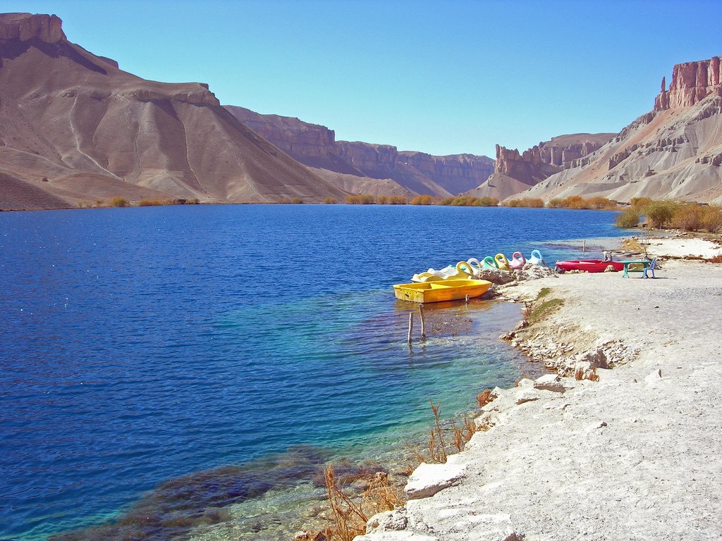
| Image | Source | Author | Licence | Reuse notes | Attribution |
|---|---|---|---|---|---|
| Afghanistan-nuristan-province 158th Infantry | commons.wikimedia.org | U.S. Army photo by Staff Sgt. Isaac A. Graham | Public domain | Broad Nuristan mountain image; commercial reuse and modification appear allowed | U.S. Army / Staff Sgt. Isaac A. Graham, public domain, via Wikimedia Commons |
GPX / KML links
| Source | URL | Format | Licence / terms | Reuse status |
|---|---|---|---|---|
| Koryo Tours: Travel Unseen Afghanistan | koryogroup.com | Itinerary source | Site terms apply; no GPX licence found | Time and route concept only |
| OpenStreetMap search: Parun Nuristan | openstreetmap.org | Map/search | OSM data is ODbL | Geometry cross-check only |
External links
2. Wama / Chitraas Cedar-Valley Walk
Snapshot
Itinerary
This candidate uses the Wama / Chitraas landscape as a day-walk objective: village paths, terraced slopes, and forested side hills rather than a high pass. Commons metadata verifies open imagery from Chitraas, Wama, and current travel sources describe Wama/Nuristan as a forested mountain area, but no official trail line or statistics were found.
Field use should define a short out-and-back from the village to a locally approved forest or terrace viewpoint.
Why it is essential
Nuristan is unusual within Afghanistan for its forested Hindu Kush valleys. A Wama / Chitraas walk gives the selection its clearest cedar-valley and settlement-landscape representative.
Equipment
Boots, rain layer, modest clothing, water, food, and offline navigation. Use a local guide and confirm all access with village authorities.
Hazards and notes
- The online record is place-based rather than route-based.
- Access, security, land ownership, and local restrictions are unresolved.
- Do not use this as a standalone GPX route.
GPX / KML links
| Source | URL | Format | Licence / terms | Reuse status |
|---|---|---|---|---|
| OpenStreetMap search: Wama Nuristan | openstreetmap.org | Map/search | OSM data is ODbL | Geometry cross-check only |
| TryDetour / Nuristan overview | trydetour.com | Travel overview | Site terms apply; no GPX found | Candidate activity context only |
External links
3. Urmir to Upper Kamdesh Historic Ascent
Snapshot
Itinerary
Archival travel sources describe a climb from Urmir up through holly-oak forest to Kamdesh, and a separate 1976 account calls the upper Kamdesh village a hard two-hour hike. Modern conditions, access rules, and the exact safe line are not publicly verified. The catalogue route is therefore a historic ascent concept: from a lower valley access point to the upper village and viewpoints, returning by the same path or by a locally approved village path.
Why it is essential
Kamdesh is the classic Nuristani mountain-village name in outside travel literature, tied to Eric Newby’s “A Short Walk in the Hindu Kush” region and later accounts of Bashgal/Nuristan. It is culturally and historically central to the Eastern Hindu Kush walking imagination.
Equipment
Boots, modest clothing, rain/wind layer, water, food, headtorch, and local guide support. Carry enough supplies for delays.
Hazards and notes
- This route is not currently verified as open to independent walkers.
- The area has a long history of conflict, road washouts, and official sensitivity.
- Do not attempt without current permission and an experienced local fixer/guide.
Photos
Photo status: No licence-compatible route-specific image found in this pass. Broad Nuristan Commons images exist, but no confirmed open Kamdesh route image was located.
GPX / KML links
| Source | URL | Format | Licence / terms | Reuse status |
|---|---|---|---|---|
| OpenStreetMap search: Kamdesh Urmir | openstreetmap.org | Map/search | OSM data is ODbL | Geometry cross-check only |
| National Geographic archival Afghanistan account | nationalgeographic.com | Narrative source | Site terms apply; no GPX found | Historic route concept and duration only |
External links
- National Geographic — Afghanistan archival 1960s journey
- Ilford Photo — Faces of Afghanistan, 1976
- Safarat — Travelling in Nuristan
- Bylines Cymru — A welcome in the hillside: Afghanistan’s Nuristan Province
4. Waigal / Want Village-Path Walk
Snapshot
Itinerary
The Waigal / Want valleys are repeatedly identified in Nuristan descriptions as remote, path-based mountain settlements. Public sources support the existence and importance of the valley landscape but do not provide a safe, named day-hike route. A field route should therefore be created locally as a village-path out-and-back to a terrace, bridge, forest edge, or ridge viewpoint.
Why it is essential
Waigal is one of the core Nuristani valley names and gives the selection a route away from the better-known Kamdesh and Parun areas. It represents the region’s enclosed side-valley walking character.
Equipment
Boots, conservative clothing, waterproof/windproof layer, water, food, first-aid kit, and offline map/GPS. A local guide is mandatory.
Hazards and notes
- This is not a published route.
- Land access, security, slopes, dogs, river crossings, and communications are unresolved.
- Treat it as a candidate for future field verification.
Photos
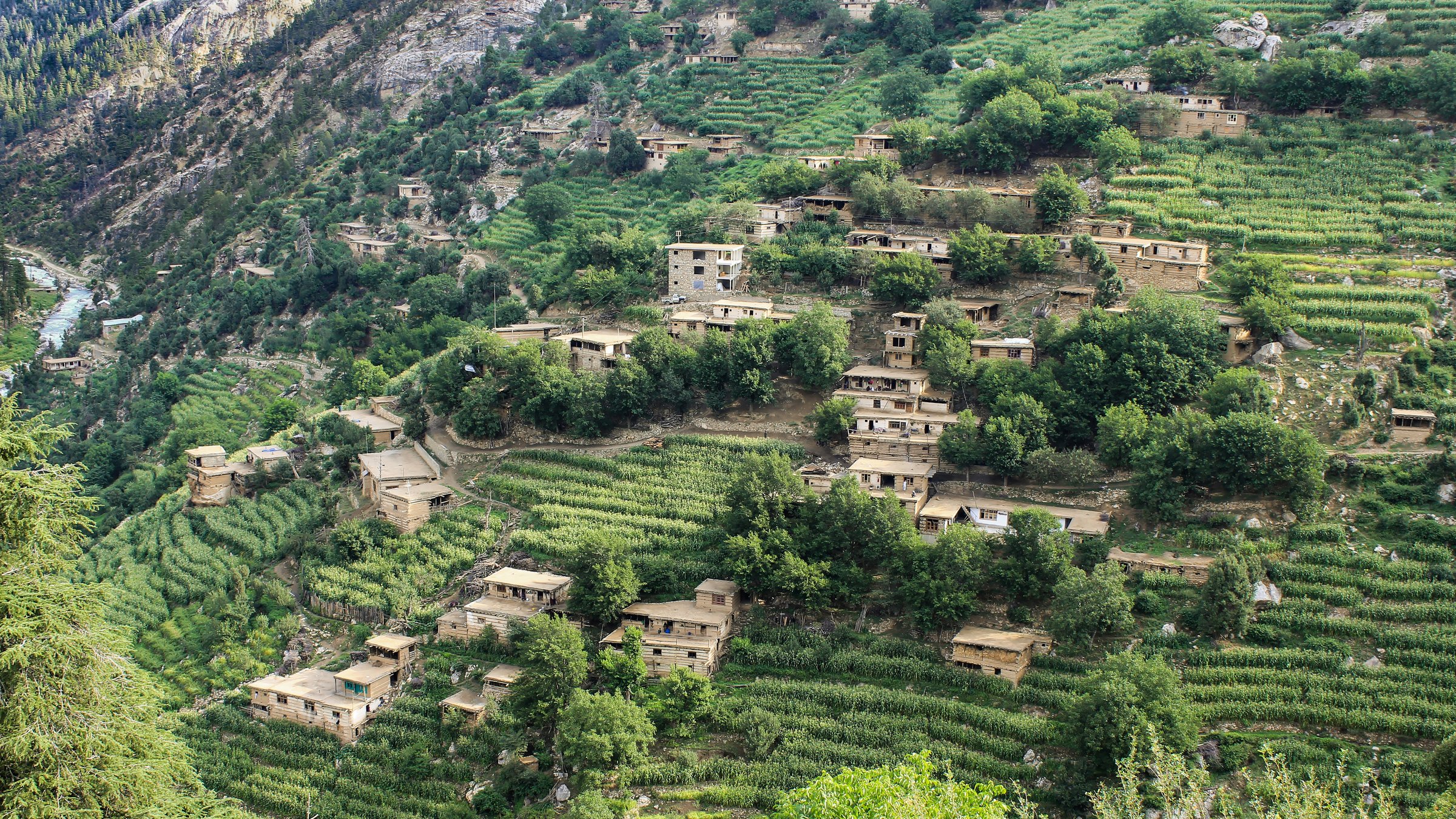
| Image | Source | Author | Licence | Reuse notes | Attribution |
|---|---|---|---|---|---|
| Chitraas, Wama, Nuristan, Afghanistan | commons.wikimedia.org | Abdul Qahar Nuristani | CC BY-SA 3.0 | Broad Nuristan valley image, not Waigal-specific; commercial reuse and modification appear allowed with attribution and share-alike | “Chitraas, Wama, Nuristan, Afghanistan” by Abdul Qahar Nuristani, CC BY-SA 3.0, via Wikimedia Commons |
GPX / KML links
| Source | URL | Format | Licence / terms | Reuse status |
|---|---|---|---|---|
| OpenStreetMap search: Waigal Nuristan | openstreetmap.org | Map/search | OSM data is ODbL | Geometry cross-check only |
| TryDetour / Nuristan things to do | trydetour.com | Travel overview | Site terms apply; no GPX found | Candidate route context only |
External links
- TryDetour — Nuristan things to do
- The Adventures of Nicole — Afghanistan travel guide
- Safarat — Travelling in Nuristan
5. Kunar / Pech Valley Viewpoint Walk
Snapshot
Itinerary
Kunar provides the lower, river-cut side of the Eastern Hindu Kush. Current travel listings identify the province’s rugged mountain trails, Kunar River landscape, and a Pech Valley viewpoint on Kabul-Nangarhar-Kunar-Nuristan tours, but no public hiking route with statistics or GPX was found. The safest catalogue treatment is a short, locally guided viewpoint walk from a road-accessible village or ridge above the Kunar/Pech valley, not a self-guided trail.
Why it is essential
The region supplied by the user explicitly includes Kunar as well as Nuristan. A Kunar/Pech viewpoint walk records the river-gorge and lower Eastern Hindu Kush character that links Nuristan with the Chitral/Kunar drainage.
Equipment
Walking shoes or boots, sun protection, modest clothing, water, first-aid kit, offline navigation, and local guide/fixer support.
Hazards and notes
- Kunar is highly sensitive and historically conflict-affected.
- Security, roadblocks, permissions, and local acceptance dominate route feasibility.
- No GPX-grade route was verified.
Photos
Photo status: No licence-compatible route-specific image found in this pass. Some public-domain military images from Kunar exist on Commons, but they were not suitable as catalogue hiking imagery.
GPX / KML links
| Source | URL | Format | Licence / terms | Reuse status |
|---|---|---|---|---|
| OpenStreetMap search: Asadabad Kunar Pech Valley | openstreetmap.org | Map/search | OSM data is ODbL | Geometry cross-check only |
| Travel To Afghanistan: Kabul-Nangarhar-Kunar-Nuristan itinerary | traveltoafghanistan.org | Itinerary source | Site terms apply; no GPX found | Viewpoint concept only |
External links
- TryDetour — Kunar overview
- Travel To Afghanistan — Kabul-Nangarhar-Kunar-Nuristan itinerary
- Koryo Tours — Travel Unseen Afghanistan
External links
| Source | URL |
|---|---|
| UK FCDO — Afghanistan travel advice | gov.uk |
| U.S. State Department — Afghanistan travel advisory | travel.state.gov |
| Koryo Tours — Travel Unseen Afghanistan | koryogroup.com |
| The Adventures of Nicole — Afghanistan travel guide | adventuresoflilnicki.com |
| TryDetour — Nuristan things to do | trydetour.com |
| TryDetour — Kunar overview | trydetour.com |
| Travel To Afghanistan — Kabul-Nangarhar-Kunar-Nuristan itinerary | traveltoafghanistan.org |
| National Parks Association — Nuristan National Park profile | nationalparksassociation.org |
| Safarat — Travelling in Nuristan | safarat.co |
| Bylines Cymru — A welcome in the hillside: Afghanistan’s Nuristan Province | bylines.cymru |
| National Geographic — Afghanistan archival 1960s journey | nationalgeographic.com |
| Ilford Photo — Faces of Afghanistan, 1976 | ilfordphoto.com |