A note on scope
The Northern Livingstones do not support five essential day-hikes. The northern end of the range — the country from approximately the latitude of Boundary Hut and Taipo Hut northward over the Pass Burn divide to the head of the Mararoa, the Mavora–Greenstone saddle, and on to the boundary with the Greenstone catchment at The Divide — is exclusively backcountry tramping terrain. There is no road, no signposted day-walk circuit, no visitor centre, no public transport, no marked summit route, and no Department of Conservation–published day-hike for this sector. The handful of objectives that lie inside the northern Livingstones (Moffat Peak 2,102 m, Snow-Wreath, Mt Eldrig, the head of the East Eglinton, the upper Windon Burn) are described uniformly as multi-day route-grade ventures on the open tops, without marked tracks, requiring overnight camps and self-reliant alpine navigation. Three day-hikes are rendered below — and the article is honest about that ceiling rather than padding to five.
Regional overview
The Livingstone Mountains are a north–south range in Southland on the South Island of New Zealand, forming the eastern boundary of Fiordland National Park between the Eglinton / Te Anau – Milford Road on the west and the Mararoa River and Mavora Lakes on the east. The range runs from South Mavora Lake at its southern end to The Divide on the Te Anau – Milford Road at its northern end, where it abuts the Routeburn and Darran Mountains country beyond.
The Northern Livingstones sector — as defined for this catalogue — covers the country from the latitude of Boundary Hut at the head of North Mavora Lake, north over the Pass Burn and Mavora Saddle divide to Taipo Hut at the head of the Greenstone catchment, and on to the watershed at The Divide where the range meets the Routeburn Track. Laterally it sits between the Mararoa River (and its headwater tributaries draining south-east into North Mavora Lake) on the east, and the East Eglinton and Windon Burn on the west. The principal summits are Moffat Peak (2,102 m) — the highest in the range, between the head of the Windon Burn and the East Eglinton — together with Mt Eldrig, Snow-Wreath, and a string of unnamed 1,700–1,900 m tops. The valley floors carry red beech forest on the lower slopes and open tussock above the bushline; the western escarpment along the Livingstone Fault rises steeply from the East Eglinton valley.
The principal walker access is from the south via State Highway 94 between Mossburn and Te Anau, with signposted turn-offs at Centre Hill or Burwood Station; from either turn-off it is approximately 39 km of gravel road (Mavora Lakes Road) to the Mavora Lakes campsite at the head of South Mavora Lake. Te Anau is roughly 90 minutes away by car. There is no public transport to Mavora Lakes; the nearest scheduled buses run on SH 94. Reaching the northern Livingstones from the south requires walking the full length of North Mavora Lake’s western shore (10 km to Careys Hut, a further ~6 km to Boundary Hut, then ~12 km of upper Mararoa to Taipo Hut). From the north, the head of the range is accessed from The Divide trailhead on SH 94 via the Greenstone or Caples valleys, but those approaches drop into Greenstone catchment country rather than into the Livingstones proper.
The hike-friendly season is December to April. The northern Livingstones, closer to the main divide than the southern end, are more exposed to Fiordland weather, and the tops carry residual snow into early summer. Mobile phone coverage is intermittent at the southern end and effectively absent from Careys Hut north. A Personal Locator Beacon is the regional norm. Dogs are permitted on lead between the Mavora campsite and Boundary Hut but are not allowed beyond.
The area is part of the Mavora Lakes Conservation Park and lies inside the Te Wāhipounamu / South-West New Zealand World Heritage Area. The Mavora basin doubled for several Lord of the Rings locations, which has driven some tourism unrelated to the tramping value of the range.
For the southern half of the range — South Mavora Lake circuit, Kiwi Burn Hut loop, and the Mavora campsite to Careys Hut return — see the companion Southern Livingstones essential day-hikes article.
Selection rationale
The brief asks for routes that are iconic, representative of the landscape, scenically important, summit / lake / pass / ridge objectives, widely recognised by DOC and local clubs, and feasible as a day hike for fit walkers in normal summer conditions.
In the Northern Livingstones sector:
- There are no DOC-published or guidebook-published day-hike summit routes. Moffat Peak, Snow-Wreath, Mt Eldrig and the unnamed northern tops are described uniformly as multi-day expedition objectives, with overnight camps on the tops and self-reliant alpine navigation. There are no marked tracks above the bushline anywhere in the sector.
- The published walking routes are all sections of the Mavora Walkway / Mavora–Greenstone Walkway. They run along the valley floor at the foot of the Livingstones rather than into the range itself.
- The companion Southern Livingstones file already covers the South Mavora Lake circuit, the Kiwi Burn Hut loop, the Kiwi Burn Hut return, and the Mavora campsite → Careys Hut return. Those are not duplicated below. The Northern Livingstones list begins from Careys Hut northward.
Three entries are rendered: the canonical Careys Hut → Boundary Hut return under the western escarpment; the long-day extension from the Mavora campsite that puts a walker into the northern sector and back to the road in a single push; and the hut-to-hut crossing of the Pass Burn / Mavora Saddle to Taipo Hut, the only walking route that crosses the northern terminus of the range.
Summary table
| # | Hike | Route type | Distance | Gain | Max elevation | Difficulty |
|---|---|---|---|---|---|---|
| 1 | Careys Hut → Boundary Hut return | Out-and-back | ~12 km | ~50 m | ~620 m | Easy tramping |
| 2 | Mavora campsite → Boundary Hut return (long day) | Out-and-back | ~32 km | ~100 m | ~620 m | Easy but long (8–10 h) |
| 3 | Boundary Hut → Taipo Hut (Mavora Walkway day section) | Point-to-point | ~12 km | ~270 m | ~890 m | Easy tramping, one low pass |
Honourable mentions — objectives that do not meet the day-hike definition for this sector:
| Hike | Why excluded |
|---|---|
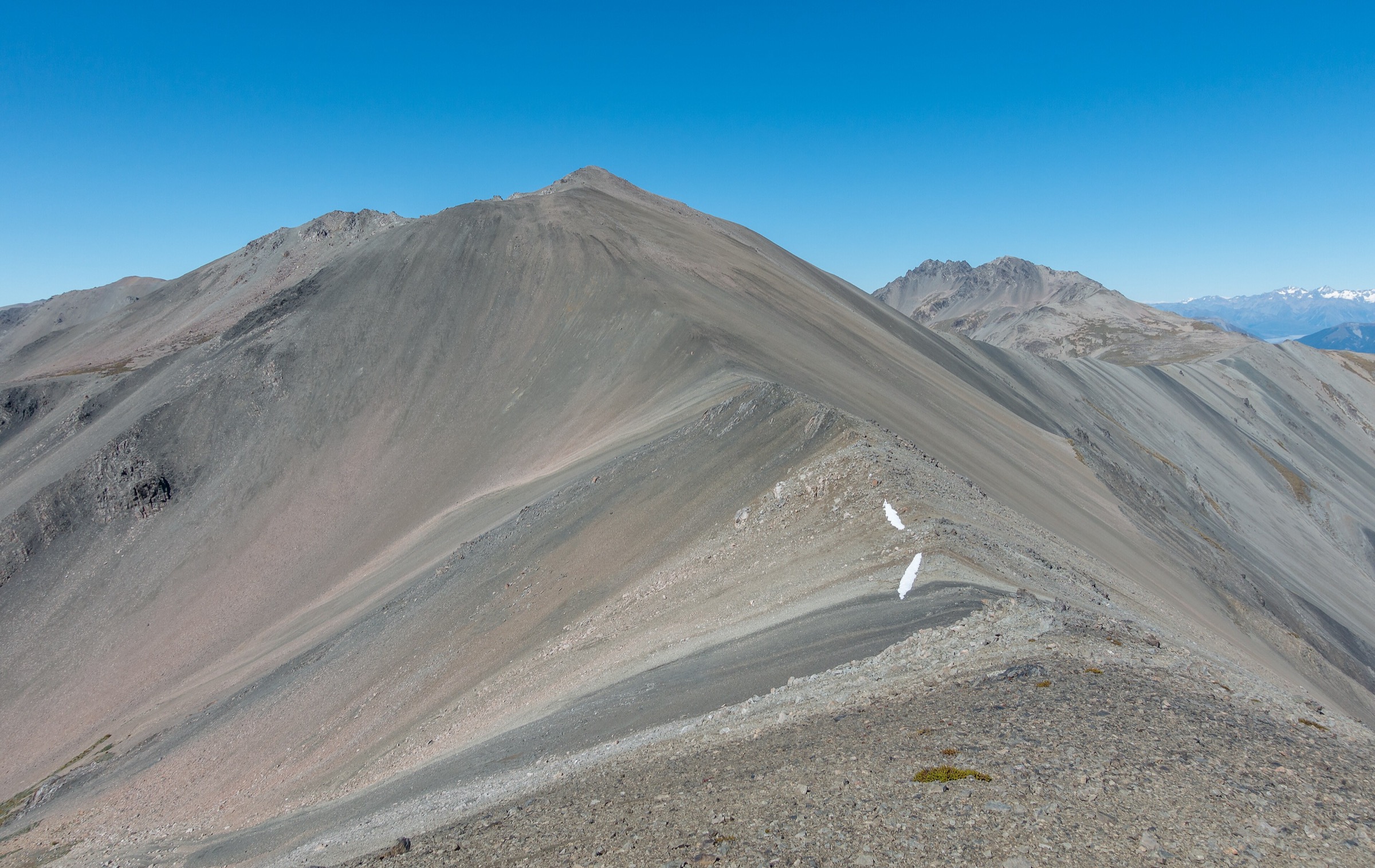
| Moffat Peak (2,102 m) — highest summit in the range | No marked track above the bushline; multi-day expedition on open tops with overnight camps; access from the East Eglinton or via the Windon Burn |
| Snow-Wreath / Mt Eldrig tops circuit | Route-grade tramping across the open Livingstone tops; no marked track; described as multi-day |
| Mavora–Greenstone Walkway (full traverse) | 50 km, 3–4 days; individual day-sections are covered by Hikes 1–3 above |
| Windon Burn → Livingstone tops → East Eglinton (Livingston Loop) | 82 km, 2,097 m ascent, 3–5 day route; through-Livingstones traverse but emphatically multi-day |
| Greenstone valley day-walks from The Divide / Greenstone Road end | In the Greenstone catchment, not the Livingstones; covered separately |
1. Careys Hut → Boundary Hut return
Snapshot
Itinerary
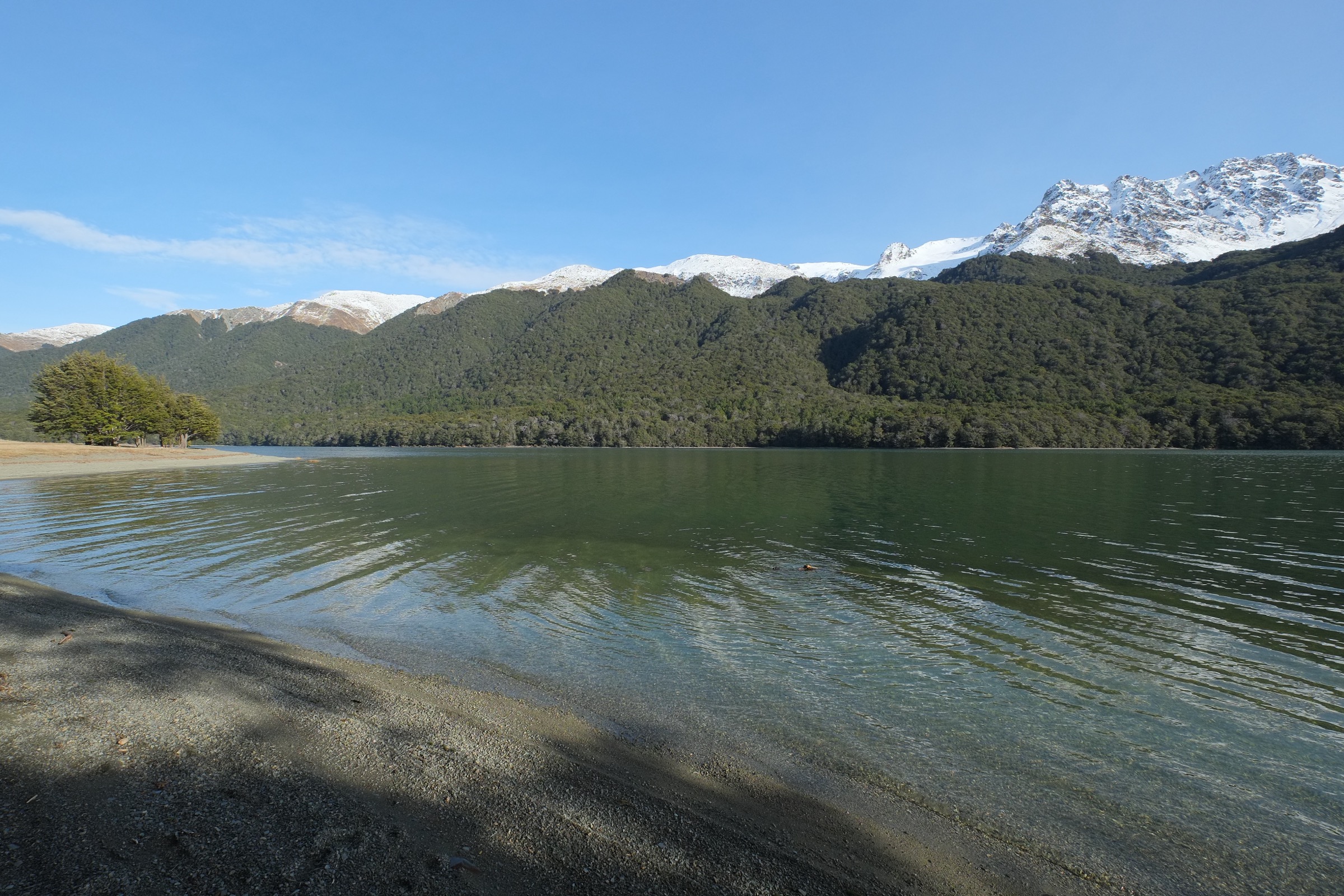
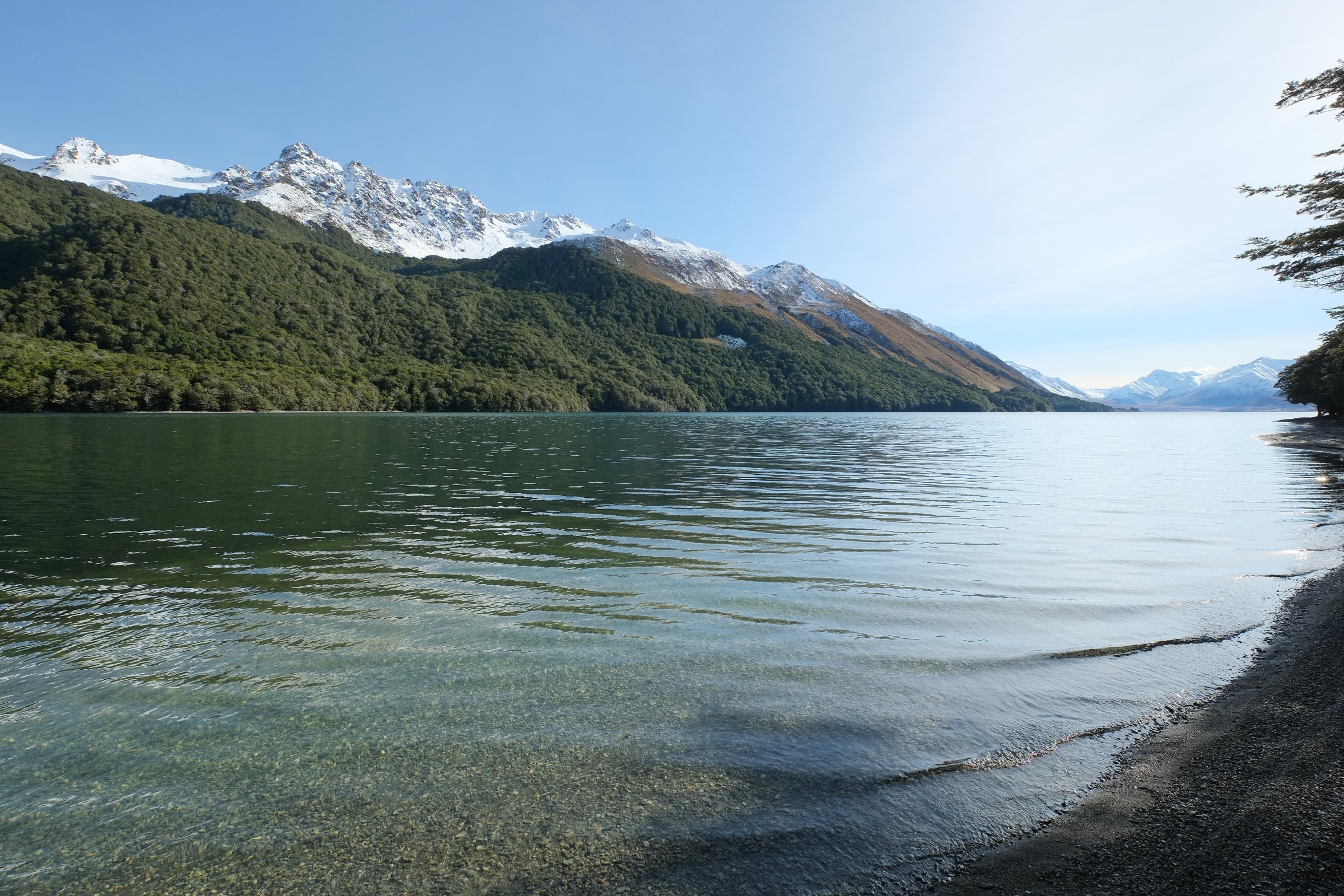
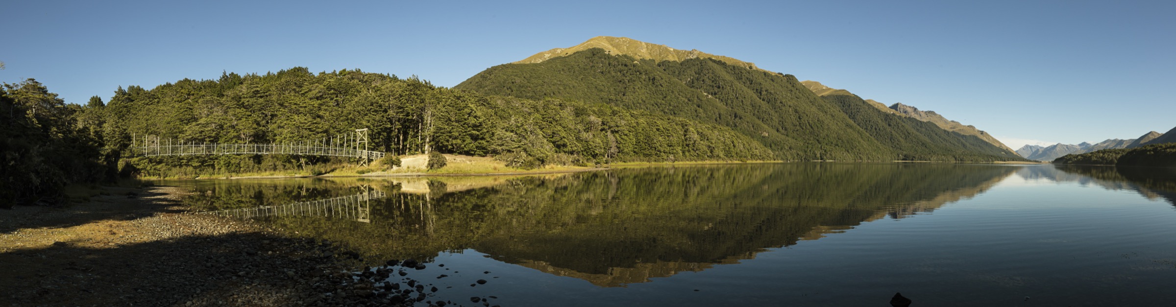
From Careys Hut (NZTM2000 E1220148 N4984758, six-bunk standard DOC hut at the head of North Mavora Lake), the track continues north along the western shore of the lake at lake level, under the steep western escarpment of the northern Livingstones. Beyond the foot of the lake it traverses tussock river-flats along the upper Mararoa to reach Boundary Hut (12-bunk standard DOC hut, on the true right of the Mararoa near where the river leaves the foot of the northern Livingstones). Return is along the same track. The whole walk is at valley-floor altitude (≈600–620 m) and follows part of the Mavora–Greenstone Walkway and the Te Araroa Trail.
Why it is essential
It is the canonical Northern Livingstones day-hike: it follows the foot of the range’s western escarpment along the northern half of North Mavora Lake, ends at a DOC hut at the boundary of the Mavora basin and the upper Mararoa, and gives uninterrupted views of the northern Livingstone tops to the west. It is part of the Te Araroa Trail, which gives it national recognition. It is the only published walking route that enters the northern sector and returns from a hut in a half-day window.
Equipment
Standard hiking equipment: walking shoes or boots; weatherproof shell; warm layer; sun protection (exposed lake-shore and river-flat); 1.5 to 2 L of water; insect repellent (sandflies are persistent at the lake margin); LINZ Topo50 sheet CC10. No specialist equipment required.
Hazards and notes
- The lake-shore is exposed to strong westerly winds funnelling down off the Livingstones; afternoon nor-west fronts can arrive rapidly.
- Vehicles (4WD with gate code) are permitted between the Mavora campsite and Careys Hut; no vehicles beyond Careys.
- Dogs are permitted on lead to Boundary Hut; not allowed beyond Boundary Hut.
- No mobile phone reception north of the Mavora campsite.
- Careys Hut and Boundary Hut are first-come, first-served (standard hut fee).
- The upper Mararoa can rise after heavy rain; the track stays on the true left and does not require river crossings between Careys and Boundary.
GPX / route file
| Source | URL |
|---|---|
| OpenStreetMap — Mavora Walkway alignment, North Mavora Lake western shore | openstreetmap.org |
| Te Araroa Trail — official GPX downloads (Mavora Walkway segment) | teararoa.org.nz |
| Herenga ā Nuku Aotearoa — Mavora Walkway track page | herengaanuku.govt.nz |
2. Mavora campsite → Boundary Hut return (long day from the road)
Snapshot
Itinerary
The full-day extension that puts a walker into the Northern Livingstones sector and back to the road in a single push. From the Mavora Lakes Conservation Campsite the route follows the 4WD track around the eastern shore of South Mavora Lake and along the western shore of North Mavora Lake to Careys Hut at the head of the lake (10 km; 1 h 30 min – 2 h). From Careys, the walking track continues north across river flats along the upper Mararoa under the foot of the northern Livingstones’ western escarpment, reaching Boundary Hut after a further 6 km (1 h 30 min – 2 h). Return is along the same route. The entire walk follows the Mavora–Greenstone Walkway and the Te Araroa Trail.
Why it is essential
It is the only way to experience the Northern Livingstones as a self-contained day-hike from a public road end without an overnight at Careys Hut. It traverses the entire length of the Livingstone Mountains’ western escarpment from South Mavora Lake to the upper Mararoa, and turns around at Boundary Hut — the unofficial gateway to the northern sector. It is included as a long-day option for fit, experienced walkers; for most parties a hut night at Careys is preferable, in which case the route becomes Hike 1.
Equipment
Standard hiking equipment with an emphasis on weight efficiency for the long distance: sturdy walking shoes or boots; weatherproof shell; warm layer; sun protection; 2 to 2.5 L of water (carry it, do not draw from the lake); insect repellent; head-torch for an early start or late finish; LINZ Topo50 sheets CC10 and CD10.
Hazards and notes
- Long day on foot; daylight is the principal constraint outside midsummer.
- The 4WD track is shared with vehicles between the campsite and Careys Hut; walkers should expect occasional vehicles in season. No vehicles or bikes beyond Careys.
- The lake-shore is exposed to strong westerly winds; weather can change rapidly.
- Dogs are permitted on lead to Boundary Hut.
- No mobile phone reception north of the campsite; carry a PLB.
- Mavora Lakes Road is 39 km of gravel from SH 94; no winter maintenance commitment.
GPX / route file
| Source | URL |
|---|---|
| OpenStreetMap — Mavora Walkway full alignment from the campsite to Boundary Hut | openstreetmap.org |
| Te Araroa Trail — official GPX downloads (Mavora Walkway segment) | teararoa.org.nz |
| Herenga ā Nuku Aotearoa — Mavora Walkway track page | herengaanuku.govt.nz |
3. Boundary Hut → Taipo Hut (Mavora Walkway day section)
Snapshot
Itinerary
From Boundary Hut (12-bunk standard DOC hut on the true right of the upper Mararoa near the foot of the northern Livingstones), the Mavora Walkway crosses river flats and beech-fringe forest up the Pass Burn to the Mavora Saddle / Pass Burn divide (~890 m), which marks the watershed between the Mararoa (Mavora / Southland) and the Greenstone (Wakatipu) catchments. The track descends the upper Greenstone tributaries to Taipo Hut (12-bunk standard DOC hut at the head of the Greenstone), a further 6 km from the pass. The section is the central part of the Mavora–Greenstone Walkway and the Te Araroa Trail.
Why it is essential
It is the only walking route that crosses the Northern Livingstones’ northern terminus (via the Mavora Saddle / Pass Burn divide), and it gives the closest day-walk view of the northern Livingstone tops from the valley floor as the divide is approached. It is included for completeness as the canonical hut-to-hut day section over the northern divide, even though it is not a day-hike from a road end. Walkers undertaking the full Mavora–Greenstone Walkway as a 3–4 day tramp will walk this leg as one of their middle days.
Equipment
Standard hiking equipment plus mountain-hiking layers for the pass crossing: sturdy boots; weatherproof shell; extra warm layer (the pass is exposed); hat and gloves outside midsummer; 1.5 to 2 L of water; insect repellent; LINZ Topo50 sheet CC10.
Hazards and notes
- The Pass Burn divide is exposed; weather can change rapidly and snow can linger into early summer.
- River flats can be boggy after rain; gaiters useful.
- Dogs are not allowed beyond Boundary Hut.
- No mobile phone reception.
- Both Boundary Hut and Taipo Hut are first-come, first-served (standard hut fee).
- This is a one-way day; without a hut night at one end it cannot be done as a road-to-road day-hike.
GPX / route file
| Source | URL |
|---|---|
| OpenStreetMap — Mavora Walkway, Boundary → Pass Burn → Taipo alignment | openstreetmap.org |
| Te Araroa Trail — official GPX downloads (Mavora Walkway segment) | teararoa.org.nz |
| Herenga ā Nuku Aotearoa — Mavora Walkway track page | herengaanuku.govt.nz |
Closing notes and follow-up
The Northern Livingstones list stops at three because a meaningful fourth or fifth day-hike does not exist for the sector as defined. Moffat Peak (2,102 m), Snow-Wreath and Mt Eldrig are multi-day route-grade tramps with overnight camps on the open tops. The Mavora–Greenstone Walkway day-sections beyond Taipo Hut drop into the Greenstone catchment rather than into the Livingstones. The East Eglinton and Windon Burn approaches from SH 94 on the western flank require fording large rivers and access to private leasehold land. The Hike 2 long-day option is included as the only way to combine the Northern Livingstones experience into a single road-to-road day for fit walkers.
A few specific data points should be confirmed against the latest LINZ Topo50 sheets and DOC pages before serious trip planning: the elevation of the Mavora Saddle / Pass Burn divide is given as approximately 890 m from Topo50 readings (not separately published by DOC); Boundary Hut and Taipo Hut coordinates should be confirmed from DOC hut pages or Topo50 before publication; and the Mt Eldrig and Snow-Wreath peak elevations cited locally should be checked against Topo50 sheet labels. The Te Araroa Trust publishes official GPX/KMZ downloads of the Mavora Walkway but does not state precise reuse terms on the download page header; DOC itself does not publish official GPX files for any Mavora Walkway section, so OpenStreetMap (ODbL) is the most usable open-licence geometry source.
External links
| Source | URL |
|---|---|
| Department of Conservation — Mavora Lakes Conservation Park | doc.govt.nz |
| Department of Conservation — Mavora–Greenstone Walkway | doc.govt.nz |
| Department of Conservation — Careys Hut | doc.govt.nz |
| Department of Conservation — Boundary Hut | doc.govt.nz |
| Department of Conservation — Taipo Hut | doc.govt.nz |
| Department of Conservation — Mavora Lakes conservation campsite | doc.govt.nz |
| Te Araroa Trust — official trail and GPX downloads | teararoa.org.nz |
| Te Araroa — Southland trail notes (Mavora Walkway) | teararoa.org.nz |
| Herenga ā Nuku Aotearoa — Mavora Walkway | herengaanuku.govt.nz |
| Wilderness Magazine — 10 trips in the Livingstone Mountains | wildernessmag.co.nz |
| Wilderness Magazine — Mavora Walkway, Southland | wildernessmag.co.nz |
| NZ Route Guides — Livingston Loop Windon Mararoa | routeguides.co.nz |
| Wilderlife — Forgotten Lands: Mavora and Livingstone Ranges | wilderlife.nz |
| LINZ Topo50 — sheets CC10 and CD10 (North Mavora Lake / upper Mararoa) | linz.govt.nz |
| Wikipedia — Mavora Lakes | en.wikipedia.org |
| Wikipedia — Mararoa River | en.wikipedia.org |
| Wikimedia Commons — Mavora Lakes category | commons.wikimedia.org |
| Wikimedia Commons — North Mavora Lake category | commons.wikimedia.org |
| AllTrails — Mavora Lakes Conservation Park | alltrails.com |