Regional overview
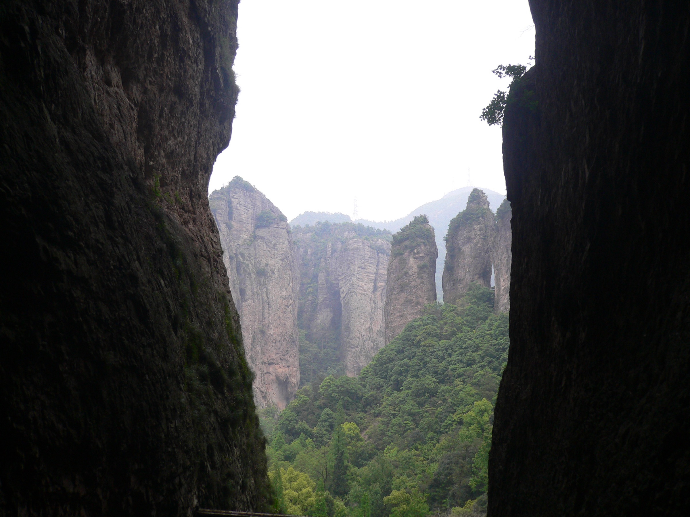
Yandang Shan (雁荡山, “Wild-Goose-Marsh Mountains”) is the coastal volcanic range that fills the southern shoulder of Zhejiang between the city of Yueqing and the East China Sea. Geologically, it is the eroded core of a Mesozoic acidic-volcanic caldera complex — the rhyolite tuffs and welded ignimbrites that erupted 120–130 million years ago have weathered into a forest of vertical pinnacles, freestanding columns, balanced rocks, ribbon waterfalls and cliff-bound amphitheatres unlike anywhere else on the eastern China seaboard. The whole massif was inscribed as a UNESCO Global Geopark in 2005 for exactly this volcanic-rhyolite landform suite, and the central core has carried national-park-equivalent protection since 1982. Maximum elevations are modest by Chinese mountain standards — the summit of Baigang Jian (百岗尖, 1,150 m) is the high point of the range — but vertical relief is concentrated and the walking is steep, theatrical and short.
The hiking footprint at Yandang is split across a network of named ticketed scenic areas (景区) within the geopark rather than a single open trail system. The central cluster — Lingfeng (灵峰) in the north-east, Lingyan (灵岩) in the centre and Dalongqiu (大龙湫) in the south-west — is the classic Yandang circuit and the only part of the range that most domestic visitors see; together these three zones contain the canonical balance of cliff temples, named-peak viewpoints, cave shrines and the headline waterfall. The Fangdong (方洞) plank-path zone on the cliff line south of Lingyan and the Chaoyang Cave (朝阳洞) sub-zone north of Lingfeng are quieter satellites, both reached by short scenic-area shuttle hops or, on foot, by steep connectors. The further scenic areas — Xianqiao (仙桥), Yangjiao Cave (羊角洞), Xiansheng Gate (显胜门) and the Northeast Yandang sea-cliff coast (东海岸) — are excluded from this day-hike catalogue as either too short, too remote, or better understood as boat tours and night-time light shows than as walks.
The walking season runs March to early December. Spring (March–May) gives clear-air days, flowering azaleas on the lower cliffs and full water in the side streams; summer (June–September) is humid and hot at low elevation, with afternoon thunderstorms and the occasional typhoon — these storms also produce the heaviest Dalongqiu flows of the year. Autumn (October to mid-November) is the most popular walking window, with stable weather and golden light on the rhyolite cliffs. December is dry and crisp; winter closures are rare on the main scenic-area routes, although temperatures can drop near freezing at the higher viewpoints. The two non-negotiable timing rules at Yandang are practical rather than seasonal — visit Dalongqiu within 24–48 hours of substantial rain if you want to see the waterfall at full flow, and avoid the first three days of May (May Day) and the first week of October (National Day), when scenic-area queues can stretch past an hour at each cable car or cave entrance.
Access is straightforward by rail. Yueqing (乐清) and Yandangshan (雁荡山) stations on the Hangzhou–Shenzhen high-speed coastal corridor put Yandang within 5–6 h of Shanghai Hongqiao, 4–5 h of Hangzhou East and 1 h of Wenzhou South. From Yandangshan station a short county-shuttle hop (~15 km, 25 min) reaches Xianglingtou (响岭头), the gateway village at the entrance of the central scenic-area cluster, from where in-park sightseeing buses circulate between Lingfeng, Lingyan, Dalongqiu, Fangdong and Chaoyang Cave on a single combined ticket. Drivers from Wenzhou or Ningbo take the G15 Shenyang–Haikou expressway to the dedicated Yandang Mountain exit.
For neighbouring sub-regions in the same eastern-China region group, see Tianmu Shan, north-west Zhejiang (the inland watershed range north-west of Hangzhou). The Huangshan, Anhui page may not yet be published.
Selection rationale
Five day-hikes are presented, drawn from the central scenic-area cluster of the geopark. Two cover the headline named-peak loops (Lingfeng and Lingyan), one covers the headline waterfall route (Dalongqiu), one covers the cliff-balcony plank-path style of walking that Yandang is famous for (Fangdong), and one is the steep on-foot connector between the central scenic zones (Chaoyang Cave to Lingfeng) for hikers who want to link two zones without the in-park shuttle.
None of these routes is long by general day-hike standards — all five are between 2 and 4 km — and Yandang Shan does not deliver the long-day, big-elevation walking that the Huangshan, Tianmu and Wuyi pages do further inland. They are kept on the list because the cumulative density of named landforms per kilometre at Yandang is the highest in eastern China, and a coherent day at the geopark requires combining two or three of these short scenic-area routes into a single editorial day-plan. The further outlying scenic areas (Yangjiao Cave, Xianqiao, Xiansheng Gate, the sea-cliff coast) and the multi-day Baigang Jian ridge traverse are excluded as either too short, too peripheral or out of scope for a day-hike catalogue.
Summary
| # | Hike | Scenic area | Route type | Distance | Gain | Max elevation | Difficulty |
|---|---|---|---|---|---|---|---|
| 1 | Lingfeng Scenic Area Loop | Lingfeng (灵峰) | Loop | 3.2 km | 278 m | 237 m | Moderate |
| 2 | Lingyan Scenic Area Loop | Lingyan (灵岩) | Loop | 2.6 km | 233 m | 337 m | Moderate |
| 3 | Dalongqiu Waterfall walk | Dalongqiu (大龙湫) | Out-and-back | 4.0 km | 257 m | 449 m | Moderate |
| 4 | Fangdong cliff-balcony trail | Fangdong (方洞) | Point-to-point | 2.4 km | 338 m | 459 m | Moderate |
| 5 | Chaoyang Cave to Lingfeng connector | Chaoyang Cave (朝阳洞) → Lingfeng | Point-to-point | 3.1 km | 355 m | 371 m | Hard |
1. Lingfeng Scenic Area Loop
Snapshot
Itinerary
From the Lingfeng gate at the foot of the eastern peak cluster, the loop climbs north on stone steps into the Clasped Palm Peak (合掌峰) amphitheatre — a pair of vertical rhyolite columns that lean together to form one of the geopark’s signature silhouettes. A short staircase from the base of the columns leads up to Guanyin Cave (观音洞), a nine-storey cave temple built into the vertical cleft between the two peaks, with a 13 m statue of Guanyin on the upper level and a famous through-the-cave-mouth view of the Twin Bamboo Peaks (双笋峰) on the far side of the valley. From Guanyin Cave the route descends west, traverses past the Beidou Cave (北斗洞) Taoist shrine and the Jinji Peak (金鸡峰, “Golden Rooster”) viewpoint, and returns to the gate down the valley path past the Lingfeng Temple (灵峰寺) and a string of named freestanding rocks — the Phoenix, the Crane, the Wedded Couple — that double as silhouette landmarks at dusk. The valley is famously seen twice: once by day for the named-rock identification game, and once at dusk, when the peaks throw long shadows that reshape the silhouettes into a different set of figures, a feature unique to Yandang’s promotional canon as 夜景灵峰 (“Lingfeng by night”).
Why it is essential
Lingfeng is the easiest, busiest and most concentrated of the Yandang scenic areas, and it is a required entry for any catalogue of the geopark because the landform density per kilometre is unmatched. The loop covers two of Yandang’s three “core marvels” (Clasped Palm Peak and Guanyin Cave), the canonical multi-peak silhouette viewpoint, and the single best example of the night-view shadow-play that Yandang has been promoting for over a thousand years.
Equipment
- Light walking shoes for stone steps
- Sun protection — the loop is largely unshaded between peak clusters
- 1 L water
- Cash or mobile-payment for scenic-area entry ticket
- Camera for the through-cave view from Guanyin Cave
- Head torch if staying for the night-view shift after dusk
Hazards and notes
- Stone steps inside Guanyin Cave are exceptionally narrow and steep; queues can stack at the cave entrance on weekends.
- The loop is short but the upper Clasped Palm Peak amphitheatre is fully exposed — descend before late-afternoon thunderstorms in summer.
- The scenic area enforces ticket checks at the Lingfeng gate; on-foot bypass is not possible.
- Night-view hours are seasonal; confirm the closing time at the gate before committing to a dusk start.
2. Lingyan Scenic Area Loop
Snapshot
Itinerary
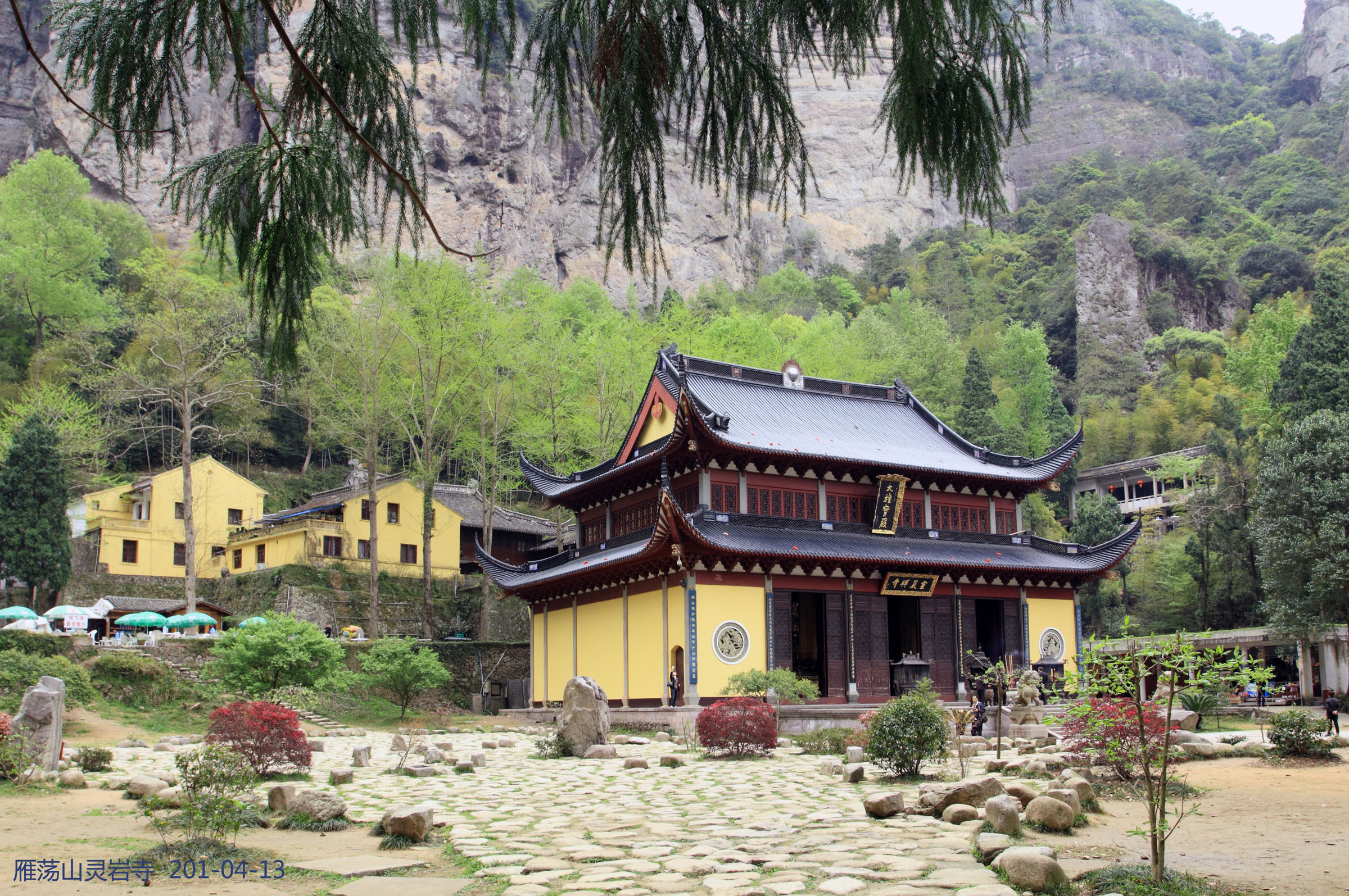
From the Lingyan gate the loop crosses the lower forecourt past the Tianzhu Peak (天柱峰, “Heavenly Pillar”) column — a freestanding 270 m rhyolite stack that is the dominant landmark of the central scenic area — and enters the inner amphitheatre to Lingyan Temple (灵岩寺), a Tang-dynasty foundation rebuilt in the Ming and again in the early twentieth century. From the temple the path climbs east up the cliff base to the Xiaolongqiu (小龙湫, “Lesser Dragon Pond”) waterfall, then traces the wooden balcony around the inner cliff to the Yiyiyou (一线天, “Single Strand of Sky”) slot canyon and the Zhuoshi (卓笔) “Standing Brush” pinnacle. The descent loops past the Feiduyan rope walk (飞渡岩, “Flying Crossing Cliff”) — a traditional rope-and-pulley aerial act performed twice daily between Tianzhu Peak and the Zhanqi Peak on the opposite cliff — and returns to the gate down the western temple lane. A modern glass cliff walkway is signed off the upper loop; access is sold separately at the gate and seasonal.
Why it is essential
Lingyan is the centre of the central scenic-area cluster and the home of Yandang’s most famous standing-rock landmark — Tianzhu Peak — and its oldest continuously operating temple. The loop also contains the second of the geopark’s “three marvels” (Xiaolongqiu, the smaller of the two Yandang waterfalls, complementing Dalongqiu in the next entry). The Feiduyan rope walk is a Yandang-specific cultural performance that has been recorded since the Ming dynasty and that no other scenic area in eastern China stages today.
Equipment
- Sturdy walking shoes for the cliff-base stair sections
- Wind shell at the upper balcony — wind funnels through the amphitheatre
- 1 L water (refill at temple kiosks)
- Sun protection
- Cash or mobile-payment for entry and for the optional glass walkway
Hazards and notes
- The glass walkway is sold as a separate ticket and operates seasonal hours; do not assume it is open without checking at the gate.
- The Feiduyan rope-walk performance times are typically posted at the lower forecourt; arrive 20 minutes early for a good view.
- Stone steps around Xiaolongqiu are slippery in spring spray and after summer rain.
- The cliff-base path is fully exposed to thunderstorms; descend at first thunder.
- On busy weekends the inner amphitheatre is one of the loudest parts of the geopark; for quieter walking, arrive before 09:00 or after 15:00.
3. Dalongqiu Waterfall walk
Snapshot
Itinerary
From the Dalongqiu gate the route walks south up the Lianyun Gorge (连云峡) — a long, narrow rhyolite canyon lined with named peaks: Scissors Peak (剪刀峰), which slowly transforms into a Heron, then a Climbing Bear, then a Crowing Cock as the angle changes along the path; Tianzhu (Heavenly Pillar) outer view; and the Yipan (一帆, “Single Sail”) column. At ~1.5 km the gorge opens into the inner amphitheatre and the Dalongqiu (大龙湫, “Great Dragon Pond”) waterfall comes into view at the head of the cliff — a 197 m single-drop ribbon waterfall over a vertical rhyolite headwall, regarded as the canonical waterfall image of southeast China and the longest single-leap fall in the country by classical accounts. The path continues to a viewing platform almost directly under the fall, then returns the same way to the gate. The waterfall ribbon is wind-driven and rarely vertical: in low water it disperses to mist before reaching the pool, and in high water — typically the day or two after a typhoon front — it doubles into a thundering twin-strand fall.
Why it is essential
Dalongqiu is the third of Yandang’s “three marvels” and the most famous waterfall in southeast China by reputation, length and depth of literary citation. It is also the only Yandang route where the walk-in narrative of named-rock transformation (Scissors Peak’s metamorphosis along the gorge) functions as the route’s main attraction in its own right, independent of the waterfall destination. Skipping it would leave any catalogue of Yandang incomplete; the only realistic risk is a dry visit, which the timing notes above are intended to avoid.
Equipment
- Walking shoes with reasonable grip — paving is wet near the fall
- Light rain shell or wet-weather layer near the viewing platform (spray is heavy in high water)
- 1.5 L water
- Sun protection in the open lower gorge
- Cash or mobile-payment for entry
- Camera with a long focal length for the named-peak metamorphosis sequence
Hazards and notes
- The Dalongqiu viewing platform is fully exposed to spray and wind; do not bring delicate camera gear close to the fall in high water.
- Stone paving around the inner amphitheatre is permanently wet and slippery; descend with care.
- In typhoon-warning weather the scenic area may close the inner gorge at short notice — check the WeChat notice on the gate.
- The fall reduces to a thin mist or disappears entirely in long dry spells; if visiting in October–November after a dry summer, check recent flow before paying for entry.
- The route is short and almost always best paired with one of the other scenic-area routes on the same day.
4. Fangdong cliff-balcony trail
Snapshot
Itinerary
From the Fangdong lower gate the cable car lifts to the upper cliff-balcony station at ~440 m — the foot of the Fangdong (方洞, “Square Cave”) rhyolite cliff line. From the upper station the route follows a series of suspended steel plank paths (栈道) bolted into the vertical cliff face, traversing south past Tianhe Falls (天河瀑布) and a string of cliff-side viewpoints back toward the central amphitheatre that holds Lingyan Temple — visible across the gorge below. Several side galleries cut into the cliff to Fangdong itself, a wide horizontal cave gallery used for Buddhist relic display. The descent option is either the same cable car or a stepped service path that drops to the lower gate.
Why it is essential
Fangdong is the only scenic area at Yandang where the headline experience is sustained cliff-edge exposure rather than ground-level cliff views. The plank-path style of walking — bolted-on suspended walkways with several hundred metres of air below — is a Chinese mountain-tourism signature elsewhere (most famously at Huashan in Shaanxi), but the Yandang version is shorter, much more accessible and gives the unique inland-facing view back across Lingyan that no other route in the geopark provides.
Equipment
- Sturdy walking shoes; cable-car-permitted bag
- Layer for the upper cliff (10–12 °C cooler than the lower gate)
- 1 L water
- Sun protection
- Cash or mobile-payment for entry, cable car and (separately) the plank path access fee in some seasons
- Head for heights — the plank path is fully exposed
Hazards and notes
- The plank path closes for high wind and typhoon warnings; check at the lower gate before paying.
- Exposure is real — the walkway has rail and netting but the floor is open to the valley.
- Cable-car operating hours are shorter than the rest of the scenic area; confirm the last descent time on arrival.
- Walking should be one-way during peak hours; do not attempt to backtrack against weekend traffic on the plank path.
- The route should be planned as a short scenic-area visit, not as a standalone full-day hike; it pairs naturally with Lingyan or Chaoyang Cave.
5. Chaoyang Cave to Lingfeng connector
Snapshot
Itinerary
From the Chaoyang Cave upper gate the trail climbs north over a stone-step crest at ~370 m, passes the cave shrine itself — a south-facing rhyolite hollow that catches sunrise light, hence “Sunrise Cave” — and drops down the south slope through a forested side gully toward the Lingfeng valley. The connector emerges at the upper end of the Lingfeng loop above Guanyin Cave, where it joins the route described in entry 1; walkers descend through the named-rock valley to the Lingfeng gate. With an early start the line can be reversed (Lingfeng up, Chaoyang Cave down) for a sunrise-east-face start at Chaoyang and a cooler descent.
Why it is essential
This is the only one of Yandang’s central routes that gives a real foot-traffic feel rather than a scenic-area circuit. The connector is steeper than its 3 km suggests, and walkers who want to taste the on-foot side of Yandang Shan — and avoid relying entirely on the in-park shuttle bus — will get more from this single point-to-point than from any of the loops. Linking it onto the Lingfeng loop also creates the most natural compact half-day on the central side of the geopark.
Equipment
- Sturdy walking shoes for the sustained stone-step gradient
- Trekking poles helpful on the descent
- 1.5 L water — no resupply between Chaoyang Cave and the Lingfeng gate
- Layer for the upper crest
- Sun protection
- Cash or mobile-payment for in-park bus and scenic-area entry
Hazards and notes
- Plan the return logistics in advance — Chaoyang Cave and Lingfeng have separate in-park bus stops, and the connector is not a loop.
- Stone-step gradients on both sides exceed 30°; knees and quads take more punishment than on the Lingfeng loop alone.
- The connector is largely shaded but the upper crest is exposed; descend before late-afternoon thunderstorms in summer.
- Mobile coverage is intermittent on the crest; carry an offline map for the in-park shuttle stop names if needed.
- Late starts make the connector unviable; the last in-park shuttle from Lingfeng to Xianglingtou typically leaves around 17:00.
Routes excluded as out of scope
The following sit inside or adjacent to the Yandang Shan UNESCO Global Geopark but fall outside a day-hike entry, are too short to stand alone in this catalogue, or are better understood as boat tours and light shows than as walks.
- Northeast Yandang sea-cliff coast (东海岸景区). Coastal boat-and-cliff sightseeing rather than mountain walking; an editorial fit for a separate coastal page if one is ever written.
- Yangjiao Cave (羊角洞) and Xianqiao (仙桥) scenic areas. Peripheral northern zones with very short walking circuits; out of scope for a flagship day-hike list.
- Xiansheng Gate (显胜门). Cliff-and-stream sightseeing with a 200 m stone gate-pass; a strong photographic stop but a 30–40 min walk rather than a hike.
- Baigang Jian (百岗尖) summit ridge. The range high point at 1,150 m is reached only by a long forest-road traverse that is better as an overnight tramp than as a day-hike; route status is uncertain and not currently a managed scenic area.
- Lingfeng “night-view” tours. Promoted as the Lingfeng evening shift in entry 1; included here as a timing variant rather than a separate route.
Further reading
| Source | URL |
|---|---|
| Yandangshan UNESCO Global Geopark — official profile | unesco.org |
| Yandangshan scenic area — official | yandangshan.com.cn |
| Yueqing City government — tourism portal | yueqing.gov.cn |
| Zhejiang Provincial Department of Culture, Radio, Television and Tourism | ct.zj.gov.cn |
| Wikipedia — Yandang Mountains | en.wikipedia.org |
| Baidu Baike — Yandang Shan (雁荡山) | baike.baidu.com |
| Baidu Baike — Dalongqiu (大龙湫) | baike.baidu.com |
| Baidu Baike — Lingfeng (灵峰) | baike.baidu.com |
| Baidu Baike — Lingyan (灵岩) | baike.baidu.com |
| AllTrails — Lingfeng scenic area | alltrails.com |
| AllTrails — Lingyan scenic area | alltrails.com |
| AllTrails — Dalong (Dalongqiu) Waterfall scenic area | alltrails.com |
| AllTrails — Fangdong Trail and Yandang Mountain | alltrails.com |
| AllTrails — Chaoyang Cave to Lingfeng | alltrails.com |
| Wikimedia Commons — Mount Yandang category | commons.wikimedia.org |
| OpenStreetMap (ODbL 1.0) | openstreetmap.org |