Regional overview
The Dabie Mountains (大别山) form the watershed between the Huai River basin to the north and the Yangtze to the south, straddling the borders of Henan, Hubei and Anhui. This entry covers two adjacent but administratively distinct parts of the range: Tiantangzhai (天堂寨, 1,729 m) — the high core of the western Dabie, straddling the Anhui–Hubei border and the third-highest summit in the range — and the wider Hubei (Huanggang prefecture) side, which spreads west through Macheng, Luotian, Yingshan and Xishui counties.
Tiantangzhai is the most-walked summit in the western Dabie, administered as three separately ticketed scenic areas that share the same ridge: the Jinzhai Tiantangzhai 5A scenic area on the Anhui side, the Luotian Tiantangzhai 4A scenic area on the Hubei south side, and the Yingshan Dabieshan Main Peak 4A scenic area on the Hubei west side. The wider Hubei flank carries the range’s most famous mid-elevation features — the Guinness-record ancient azalea community on Mount Guifeng above Macheng, the cliff-edge ridge of Bodaofeng above Luotian, and the forest summit of Sanjiao Shan above Xishui. All of these sit inside the Huanggang–Dabieshan UNESCO Global Geopark, declared in 2018.
Walking on this side of the Dabie is predominantly engineered stone-step trail inside ticketed scenic areas, with cable cars, glass walkways, in-park sightseeing buses and a handful of via-ferrata-style cliff-side plank walks. It is closer to Huangshan or Zhangjiajie in style than to a Western national-park hiking network. Forest cover is dense subtropical broadleaf with extensive bamboo and rhododendron groves; the high ridges hold named granite tor formations and the canyon corridors carry the region’s signature waterfall sequences.
The walking season runs mid-March to mid-November. Late April through mid-May is azalea (杜鹃) season — Guifeng Shan’s ridge holds the Guinness-record largest contiguous ancient azalea community and pulls peak-day crowds in five figures. July–August is hot, humid and the busiest waterfall season at Tiantangzhai. Late October to mid-November is the autumn-colour peak. December through February brings occasional snow above 1,200 m, intermittent cable-car closures and rime ice on the upper ridges; glass walkways close in icy conditions.
Access is well-served by China’s high-speed rail network. Jinzhai (金寨) station on the Hefei–Wuhan line is the principal rail head for the Anhui-side Tiantangzhai. Macheng North (麻城北) on the Beijing–Kowloon line, Hong’an West (红安西) on the Wuhan–Macheng line, and Wuhan’s intercity coach network serve the Hubei-side gates. Mountain trailheads sit 30–100 km of mountain road from the nearest HSR station, served by combinations of county shuttle, intercity coach and taxi. There is no through-road over the Tiantangzhai summit between the Anhui and Hubei tickets — vehicles must detour around the range.
Selection rationale
Five day-hikes are presented, covering the geographic spread from Tiantangzhai in the east through Luotian and Macheng to Xishui in the west. The selection is honest about the character of the walking: most routes are paved stone-step trails inside ticketed scenic areas, with cable cars and glass walkways as standard features. This is the Chinese mountain hiking norm and is the basis on which the routes have been chosen.
The Tiantangzhai summit is selected on the Anhui (Jinzhai) side — the canonical loop combining the waterfall corridor and the main summit. The Hubei-side Luotian variant (the Zherenfeng and glass-walkway loop) is treated as the second hike. Three further hikes — Guifeng Shan, Bodaofeng and Sanjiao Shan — cover the rest of the Hubei Dabie flank.
A sixth candidate considered and dropped is the Three-Fortress Traverse (三寨连穿), a single-day ridge link between all three Tiantangzhai scenic areas. It requires three separate ticket purchases and a non-trivial vehicle shuttle between trailheads, and is reported in Chinese hiking communities rather than as an official route. The traverse is mentioned in the exclusions section for completeness.
The cross-border Henan side of the Dabie is covered in the Henan Dabie Mountains entry; the deeper Anhui interior — Baima Jian, Tianzhushan, Yaoluoping — is covered in the Anhui Dabie Mountains entry.
Summary
| # | Hike | County / side | Route type | Distance | Gain | Max elevation | Difficulty |
|---|---|---|---|---|---|---|---|
| 1 | Tiantangzhai main summit loop (Anhui side) | Jinzhai (Anhui) | Ticketed loop, lift-assisted | ~10.6 km | ~900 m | 1,729 m | Moderate |
| 2 | Zherenfeng — glass walkway loop (Hubei side) | Luotian (Hubei) | Ticketed loop, lift-assisted | 6–8 km | 500–700 m | ~1,650 m | Moderate |
| 3 | Guifeng Shan — azalea-ridge loop | Macheng (Hubei) | Lift-assisted loop | 6–8 km | 250–400 m | 1,320 m | Easy–moderate |
| 4 | Bodaofeng — Wolong Ridge and Xiguoding | Luotian (Hubei) | Lift-assisted out-and-back | 7–9 km | 350–500 m | 1,408 m | Moderate |
| 5 | Sanjiao Shan — three-peak summit | Xishui (Hubei) | Lift-assisted out-and-back | 7–9 km | 600–750 m | 1,055 m | Moderate |
1. Tiantangzhai main summit loop (Anhui side)
Snapshot
Itinerary
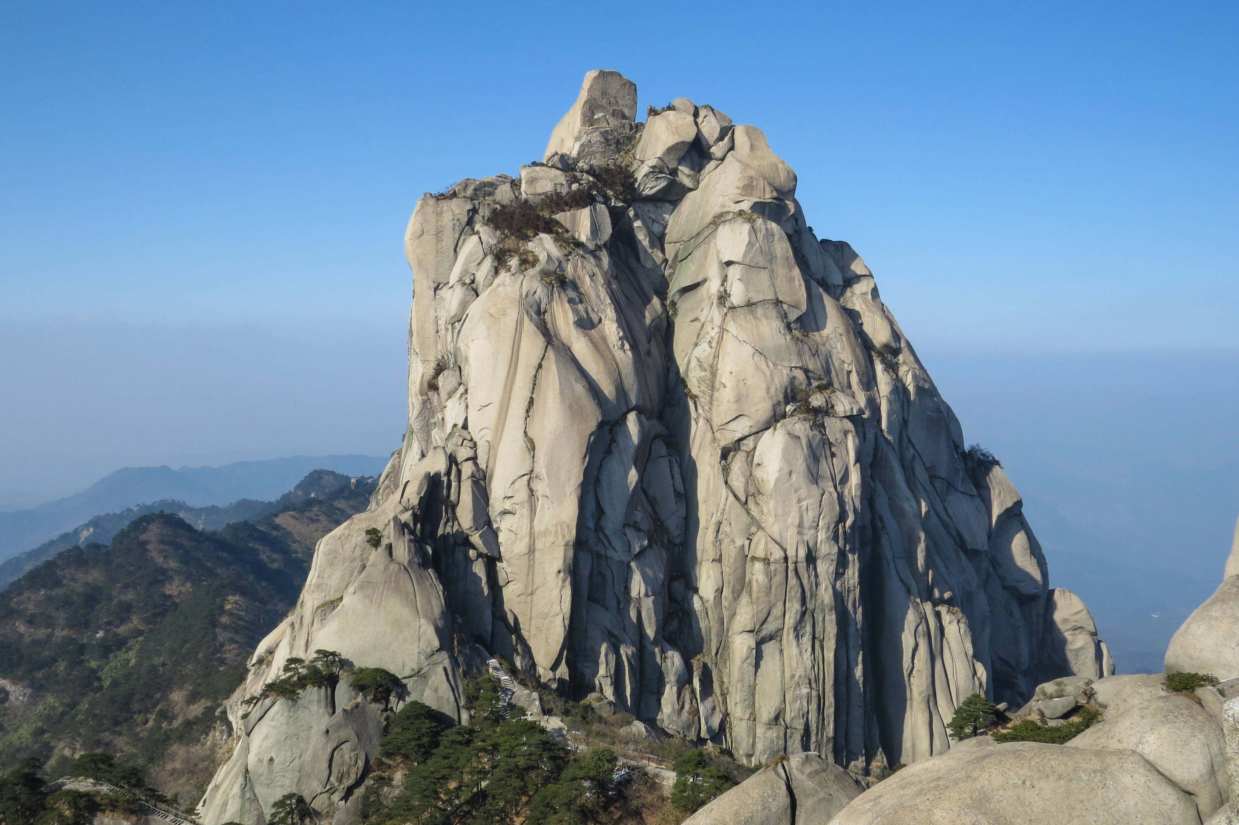
From Huxingdi (虎形地), the trail climbs past Nine-Shadow Waterfall (九影瀑, ~70 m drop) and the Lover, Xieyu, Shunü (淑女瀑) and Yingong (银弓瀑, ~68 m) falls, then continues up through the Dujuanping rhododendron flat (杜鹃坪) and the Penjing Garden (盆景园) to Lover Peak (情侣峰) and Tianping Peak (天屏峰). From Tianping Peak a ridge path passes Wuchu Pavilion (吴楚亭), Matou Peak (马头峰, ~1,500 m), Jiangjun Yan (将军岩), Songshi Lian (松石恋) and Tiantang Shengui (天堂神龟) before reaching the Longji Bei ridge (龙脊背) and the main summit at 1,729 m, marked by the Wu-Chu boundary stone (吴楚东南第一关 / 江淮分水岭). Descent is via Leipi Shi (雷劈石), back past Xieyu and Lover Waterfalls to Huxingdi. The summit-ridge cable car (大别山索道) offers an alternative ascent or descent between Huxingdi and Tianping Peak.
Why it is essential
This is the canonical Tiantangzhai itinerary: it touches the dense waterfall group that gives the Anhui side its reputation (108 falls in the scenic area, 18 with drops over 50 m), reaches the summit of the Dabie range’s western main-peak complex, and crosses the Wu–Chu / Anhui–Hubei boundary at the top. It is the route featured in Jinzhai county tourism literature as the recommended full-day visit.
Equipment
- Hiking shoes with good grip on wet stone steps
- 2 L water (limited resupply on the upper ridge outside summer)
- Sun protection
- Light waterproof
- Warm layer in shoulder season
- Trekking poles for the long descent
- Microspikes in winter for iced steps
Hazards and notes
- Long flights of wet stone steps are the main injury vector.
- Afternoon thunderstorms in summer can close the upper ridge; the cable car suspends in high wind.
- Scenic area enforces a “must descend before dark” rule; recommended entry 07:00–08:00.
- Ticket and ropeway fees apply (entry ~100 RMB; cable car single 60–70 RMB).
- Dogs are not permitted in 5A scenic areas.
2. Zherenfeng — glass walkway loop (Hubei side)
Snapshot
Itinerary
From the visitor centre, the in-park shuttle drops at the Bamboo-Forest trailhead (竹林深). The trail climbs through bamboo to Xiaohuashan (小华山), where a ~70 m glass walkway crosses the cliff face at ~1,080 m. The path continues to Shiyan Peak (石燕峰), Fairy Peak (仙女峰) and the Magpie Bridge (鹊桥) connecting two summits, then climbs to Star-Picking Peak (摘星峰) and reaches Mount Zherenfeng (哲人峰) — the cliff-shouldered summit that gives Luotian its identity. From Zherenfeng the trail passes the Giant-Python-Out-of-Mountain (巨蟒出山) rock formation and reaches the upper cable-car station. Descent is by cable car when running, or by the parallel stone-step trail. Tour operators in Luotian quote ~4 hours for this circuit; extending to the actual boundary-stone summit adds up to ~6 km return.
Why it is essential
This is the canonical Luotian (Hubei-side) Tiantangzhai day, and the only routine way to walk Zherenfeng — the cliff formation that Luotian tourism brands as one of “Tiantang’s three wonders” together with the “lying Maitreya” and “philosopher gazing at the sea” rock figures. The Magpie Bridge between two summits and the glass walkway on Xiaohuashan are the signature engineered features of the Hubei-side approach to the Tiantangzhai massif.
Equipment
- Hiking shoes for stone steps
- Wind shell for the exposed ridge between Zherenfeng and Magpie Bridge
- Shoe covers for the glass walkway (provided at entry, ~10 RMB)
- Water and snack
- Warm layer in shoulder season
- Microspikes for winter ice on iced staircases
Hazards and notes
- Slips on engineered stairs are the main injury vector.
- Exposure on the cliff-edge sections of the glass walkway and Magpie Bridge; vertigo-sensitive walkers can skip the walkway without breaking the loop.
- The Hubei-side cable car has been periodically suspended for maintenance in recent years; confirm operation before relying on it for descent.
- Through-walking to the Anhui-side summit and back is not normally possible on a single Hubei ticket.
- Glass walkway closes in high wind and winter ice.
3. Guifeng Shan — azalea-ridge loop
Snapshot
Itinerary
From the North Gate visitor centre, the sightseeing bus runs the 18 km internal road past the Guifeng Gorge stop to the cable-car lower station near Yunfeng-Shijing (云峰石径). The cable car gains roughly 400 m of vertical in ~22 minutes. From the upper station the marked circuit climbs through azalea forest on the Yunfeng Pavilion → Azalea Sea three-ring loop → Azalea Plaza → Guishou sequence. The Guishou (龟首, “Turtle Head”, 1,260 m) is the photographic highlight — a granite tor that gives the mountain its name. From Guishou the Changshou-Shijing (长寿石径) descends on stone steps to the Guankou-Ao (关口坳) bus stop, where the sightseeing bus returns to the North Gate. Variants include walking the full Guibei Ridge ancient azalea community before descending, or descending on foot all the way from the upper cable-car station via the Yunfeng-Shijing stone path.
Why it is essential
Guifeng Shan is the headline mountain of the Hubei Dabie. It was promoted to national 5A status on 27 December 2024 and is the core of the Huanggang-Dabieshan UNESCO Global Geopark on the Hubei side. The ancient azalea community along the Guibei Ridge is certified by Shanghai Guinness HQ as the largest contiguous ancient azalea community on record (>100,000 mu / ~67 km²) and draws hundreds of thousands of visitors in the late-April peak. The Guishou tor is the most-photographed natural landmark in eastern Hubei outside Wudang and Shennongjia.
Equipment
- Trail shoes (walking surface is almost entirely stone paving)
- Sun protection (exposed azalea-ridge sections)
- Water and snack
- Trekking poles for the long stair descent
- Light waterproof in shoulder season
Hazards and notes
- Crowding is the main hazard during azalea season; cable-car queues can exceed one hour on weekends.
- May Day (五一) public holiday is the worst peak; consider a weekday visit if possible.
- Cable car single-direction 60 CNY, round-trip 100 CNY; internal sightseeing-bus 40 CNY (Hubei provincial government pricing).
- Last sightseeing-bus departure times shift seasonally; check the scenic-area site before travel.
- Macaque troops along the Changshou-Shijing path can be aggressive about food; do not feed.
4. Bodaofeng — Wolong Ridge and Xiguoding
Snapshot
Itinerary
The scenic area is structured as three “theme areas”: Wolong-Gang (卧龙岗) — the ridge spine, around 1,350 m and ~3 km long; Xiguoding (锡锅顶) — a granite dome at 1,215 m to the east; and Yuanmenggu (圆梦谷) — a valley sub-loop. A typical walking day from the plaza takes the cable car up (two parallel lines of ~1,000 m run length, fares 70 CNY up / 60 CNY down), walks west to the Bodaofeng summit ridge, doubles back along Wolong Ridge to Xiguoding for the granite-dome viewpoint, then descends either by cable car or by the Yuanmenggu trail. The ridge crest is a knife-edge in places — Bodaofeng (薄刀) literally means “thin blade” — and the walking route runs entirely on engineered stone steps, timber boardwalk and a short glass walkway.
Why it is essential
Bodaofeng is the best mid-elevation ridge walk on the Hubei Dabie side outside Tiantangzhai. The scenic area covers 30 km² with claimed 98% forest cover; the ridge crest gives the broadest open views of the Dabie interior available to a non-summit walker. It is the second-most cited “must-do” Hubei Dabie destination after Guifeng Shan in regional Huanggang travel writing.
Equipment
- Sturdy hiking shoes for stone steps
- Warm layer year-round above 1,200 m
- Headlamp if descending late
- Trekking poles for the steep stair sections
- Water and snack
Hazards and notes
- Standard ticket 80 CNY (concession 40 CNY); cable car priced separately.
- Glass walkway sections are not exposure-rated to via-ferrata standard but can be uncomfortable for those with vertigo.
- Winter snow can close the cable car; sleet ice on stone steps is the main winter hazard.
- Operating hours vary seasonally; Luotian county tourism office is the most reliable contact.
5. Sanjiao Shan — three-peak summit
Snapshot
Itinerary
The 64 km² scenic area covers 28 named peaks; the three highest form the “笔架山” (brush-rest mountain) silhouette that gives Sanjiao Shan (“Three-Horn Mountain”) its name. From the main visitor centre, a service road and stone-paved hiking path climb through evergreen and deciduous broadleaf forest to the cable-car upper station; from there the main summit ridge is reached on stone steps. The Longtan Gorge (龙潭峡) drainage offers a parallel descent route past the rafting section if a loop is preferred over an out-and-back. Cable car fares are 60 CNY single / 100 CNY return.
Why it is essential
Sanjiao Shan is the high point of Xishui county and one of the recognised “笔架山” peaks of the historic Huangzhou Prefecture, with documented temple ruins and revolutionary memorials inside the scenic area. As a day-hike it offers the most genuine forest-walking experience in the southern Hubei Dabie outside Tiantangzhai itself.
Equipment
- Sturdy trail shoes
- Insect repellent and water in summer
- Warm layer in shoulder seasons
- Cash for cable car if used
- Light rain shell
Hazards and notes
- Less developed than Guifeng Shan or Bodaofeng; trail signage is in Chinese only.
- Summer storms and 1,400 mm annual rainfall mean trails can be slick.
- The Longtan Gorge rafting section is closed in winter.
- Cable car closes in high wind.
- Mobile coverage on the upper ridge is intermittent.
Routes excluded as out of scope
The following sit inside the Tiantangzhai or Hubei Dabie footprint but fall outside a day-hike entry, or duplicate routes covered on neighbouring sub-region pages.
- Three-Fortress Traverse (三寨连穿). Single-day ridge link between the three Tiantangzhai scenic areas — Yingshan, Luotian and Jinzhai — over the shared summit. Roughly 18.7 km / 950 m gain. Requires three separate ticket purchases, asymmetric start/finish in different provinces, and reliance on user-uploaded community tracks. Reported in Chinese hiking communities rather than as an official route; flagged here for completeness but not recommended as an essential day-hike.
- Baima Grand Canyon (白马大峡谷). A separately ticketed 4 km plank-walk corridor in the Jinzhai Tiantangzhai 5A area, with a 3,366 m cliff-bolted plank walkway and a height differential close to 800 m. A canyon experience rather than a mountain hike; honestly half-day in scope. Pair with Hike 1 as a two-day Tiantangzhai itinerary.
- Yanzihe Grand Canyon (燕子河大峡谷). Separate 4A scenic area ~15 km from the Tiantangzhai main gate, with a ~4.5 km ticketed canyon corridor. Easy walking; included in the broader Tiantangzhai experience but honestly a sightseeing walk rather than a hike.
- Daqi Shan / Longwangding (大崎山, 1,041 m). Tuanfeng-Luotian-Macheng tri-county border forest park; ~11.5 km loop, ~700 m gain. The most genuinely non-managed forest hike on the Hubei Dabie side, but signage and reference material are entirely in Chinese and outdoor-club traces are the only available references. Defensible as a future addition once a contributor produces a clean GPX.
- Hong’an Red Heritage walking circuit. Half-day urban-edge cultural walk linking the Huangma Uprising Memorial Park, Qilipping’s Changsheng Street, and the Fourth Red Army HQ. Genuinely “essential” for understanding Huanggang’s revolutionary heritage but not a mountain hike.
- Wujiashan / South Wudang / Tiantangding ridge (Yingshan). The Yingshan Dabieshan Main Peak scenic area shares the same summit massif as Tiantangzhai. The summit walk from Yingshan is editorially redundant with Hike 1; included in the Three-Fortress Traverse note above.
- Dabieshan National Forest Trail (大别山国家森林步道). The 840 km long-distance trail crosses 279 km of Hubei but is a multi-stage tramp, not a day-hike.
External links
| Source | URL |
|---|---|
| Hubei Provincial Department of Culture and Tourism | wlt.hubei.gov.cn |
| Macheng Guifeng Shan — official | mcgfsly.com |
| Dabieshan Main Peak Scenic Area — Yingshan portal | dbszf.com |
| UNESCO Global Geoparks — Huanggang Dabieshan | unesco.org |
| Wikipedia — Tiantangzhai | en.wikipedia.org |
| Wikipedia — Dabie Mountains | en.wikipedia.org |
| Hubei Province 2023 government-set scenic-area pricing (PDF) | hbdaye.gov.cn |
| Hefei Bendibao — Tiantangzhai cable car pricing | hf.bendibao.com |
| Wuhan Bendibao — Luotian Tiantangzhai info | m.wh.bendibao.com |
| Baidu Baike — Tiantangzhai (Luotian) | baike.baidu.com |
| Baidu Baike — Bodaofeng (薄刀峰) | baike.baidu.com |
| Baidu Baike — Sanjiao Shan (浠水三角山) | baike.baidu.com |
| Xinhua / China Services Info — Guifeng Mountain background | chinaservicesinfo.com |
| OpenStreetMap (ODbL 1.0) | openstreetmap.org |