_-_10323697814.jpg)
Regional overview
The Dabie Mountains (大别山) form the watershed between the Huai River basin to the north and the Yangtze River basin to the south, straddling the borders of Henan, Hubei and Anhui. The Henan flank lies wholly within Xinyang prefecture (信阳市), where the range presents as a series of forested granite-and-metamorphic summits between 750 m and 1,584 m. The provincial high point — and the highest peak of the Henan Dabie — is Maoershi (帽儿石, 1,584 m) on the Jingangtai (金刚台) massif above Shangcheng County; the range’s better-known cultural summits sit lower, but all share the same characteristic dense subtropical broadleaf forest, granite tor outcrops and Buddhist-Taoist temple history.
Henan’s Dabie has two distinct walking identities. The north-western front — Mount Jigong (鸡公山) above Xinyang city — is a former colonial hill-station and one of China’s “Four Summer Resorts” (四大避暑地), declared a National Forest and Geological Park and the country’s first nature reserve in 1988. Its walking is light, ridge-top and architectural, threading among more than 250 European-and-Republic-era villas. The deeper south-east interior — Jingangtai, Huangbaishan (黄柏山), Jinlanshan (金兰山) and Lingshan (灵山) — gives genuine forest-and-summit days with stone-step trails, ridge crests and cliff-cut Buddhist temples. Huangbaishan in particular sits on the tri-province boundary known locally as “Jīmíng Sānshěng” (鸡鸣三省, “the cockerel’s crow heard in three provinces”) where Henan, Hubei and Anhui meet.
The walking season runs mid-March through mid-November. April–May brings azalea and forest leaf-out; July–August is hot, humid and crowded with Wuhan and Zhengzhou summer escapees; late October to early November is the autumn-colour peak. December through February the summit ridges hold ice and intermittent snow, and the cable cars at Jigongshan, Lingshan and Jingangtai operate on reduced schedules.
Access is straightforward by Chinese standards. Xinyang East (信阳东) on the Beijing–Guangzhou high-speed rail line is the principal rail head, with Jigongshan a 25 km taxi or shuttle south. Shangcheng (商城) and Xinxian (新县) — gateways to Jingangtai, Huangbaishan and Jinlanshan — are reached by intercity bus from Xinyang or by car on the G45 Daguang Expressway. There is no public-transport access into the trailheads of Huangbaishan or the deeper Jingangtai approaches; private vehicle or county taxi is normal.
Selection rationale
Five day-hikes are presented, each anchored on a separately ticketed scenic area or national forest park. The selection covers the geographic spread of the Henan Dabie from the western front (Xinyang) to the south-east tri-province corner (Shangcheng) and includes both lift-assisted ridge walks and longer summit pushes. Most walking is on engineered stone-step trail inside ticketed scenic areas — the dominant mode of Chinese mountain hiking — but each route reaches a genuine summit or summit ridge rather than a sightseeing platform.
The Henan side is sometimes lumped editorially with the Tongbai Mountains (桐柏山) to the west; Tongbai is a separate range and is excluded here. Routes that cross the Hubei or Anhui border are flagged but selected on the Henan side; the cross-border Tiantangzhai summit is covered in the Tiantangzhai and the Hubei side entry.
Summary
| # | Hike | County | Route type | Distance | Gain | Max elevation | Difficulty |
|---|---|---|---|---|---|---|---|
| 1 | Mount Jigong — Baoxiao Peak via villa district | Xinyang (Shihe) | Lift-assisted loop | ~8 km | ~350 m | 784 m | Easy |
| 2 | Lingshan — Jinding summit sunrise | Luoshan | Out-and-back, lift optional | ~6 km | ~500 m | 828 m | Easy–moderate |
| 3 | Jingangtai — Maoershi summit via Xihe | Shangcheng | Out-and-back | ~9 km | ~750 m | 1,584 m | Moderate–strenuous |
| 4 | Huangbaishan — Jiufengjian circuit | Shangcheng | Loop | ~11 km | ~650 m | 1,352 m | Moderate |
| 5 | Jinlanshan — Jinlan and Xidashan ridge | Xinxian | Lift-assisted loop | ~8 km | ~450 m | 768 m | Easy–moderate |
1. Mount Jigong — Baoxiao Peak via villa district
Snapshot
Itinerary
From the south gate, the scenic-area sightseeing bus climbs the switchback to Yundu (云阙) at the ridge col. From there the walking route runs north along the spine of the range through the villa district — the American Mission villa, the Sino-Soviet Friendship Hall (中苏友好馆), the Heart-of-Wu Pagoda (吴家花园), the Stone Crab Spring — to the col below Baoxiao Peak (报晓峰). A stone-step staircase climbs the final 80 m to the summit and its small viewing platform. From the summit, return south along the ridge variant past the Holiness Light Cliff (圣光崖), drop to Bogong Stone Cottage (波公石屋), and rejoin the villa district to descend by the East-side stair (东方红大道) to the lower sightseeing-bus stop.
Why it is essential
Jigongshan is the cultural anchor of the Henan Dabie. It was one of China’s four imperial-era summer resorts (with Lushan, Beidaihe and Moganshan), the country’s first declared nature reserve in 1988, and a national 5A scenic area. The villa district is a uniquely complete late-Qing and Republican landscape — more than 250 buildings in over 20 architectural styles — and the Baoxiao Peak summit is the highest open viewpoint on the western Henan Dabie front. The walking is easy, the cultural density is high, and it is the standard regional introduction.
Equipment
- Light walking shoes (paved lanes and stone steps throughout)
- Water bottle and snack; cafés exist but are sparse outside July–August
- Sun protection
- Warm layer in shoulder season
Hazards and notes
- Heavy crowds in July–August and on national holidays; the sightseeing bus queues at peak times.
- Some villa interiors are working museums with entry fees inside the scenic-area ticket; others are closed and only viewable from outside.
- Macaques along the ridge can be aggressive about food; do not feed.
- Cable car operates seasonally; confirm the day’s schedule at the south gate ticket office.
2. Lingshan — Jinding summit sunrise
Snapshot
Itinerary
From the front gate, the route enters the scenic area past Lingshan Temple (灵山寺), a Tang-foundation Buddhist temple complex with surviving Ming and Qing halls. The walking trail climbs north through bamboo and broadleaf forest to Jinding (金顶, “Golden Peak”, 827.7 m), the highest of Lingshan’s named peaks. The trail is paved stone steps the whole way, with timber boardwalk on the upper ridge. A separate cable-car line runs from a lower station near the temple to a saddle below the summit, cutting roughly two-thirds of the climb. Return is the same route, or descend via the alternative Yindingfeng (银顶峰) ridge variant on the east side which loops back to the temple plaza.
Why it is essential
Lingshan is the most-walked sunrise summit on the Henan Dabie. The temple is a major regional Buddhist pilgrimage site — Empress Wu Zetian is said to have stayed here — and the summit shrine sees pre-dawn ascents on most weekends from spring through autumn. As a hike it is short and direct; as a cultural day it links a working temple with a clean summit view across the northern Dabie front.
Equipment
- Hiking shoes for damp stone steps
- Headtorch if walking for sunrise (typical pre-dawn ascent 4–5 am summer, 6–7 am winter)
- Sun and rain protection
- Cash for cable car if used (separate ticket from scenic-area entry)
Hazards and notes
- Wet stone steps below the temple stay damp most of the year; the main injury vector is slips.
- Macaques on the upper ridge can be aggressive; do not carry visible food.
- Cable car closes in high wind and occasional winter ice; confirm operation at the front gate.
- Lunar-calendar temple festivals (especially Guanyin’s birthday) bring very heavy crowds.
3. Jingangtai — Maoershi summit via Xihe
Snapshot
Itinerary
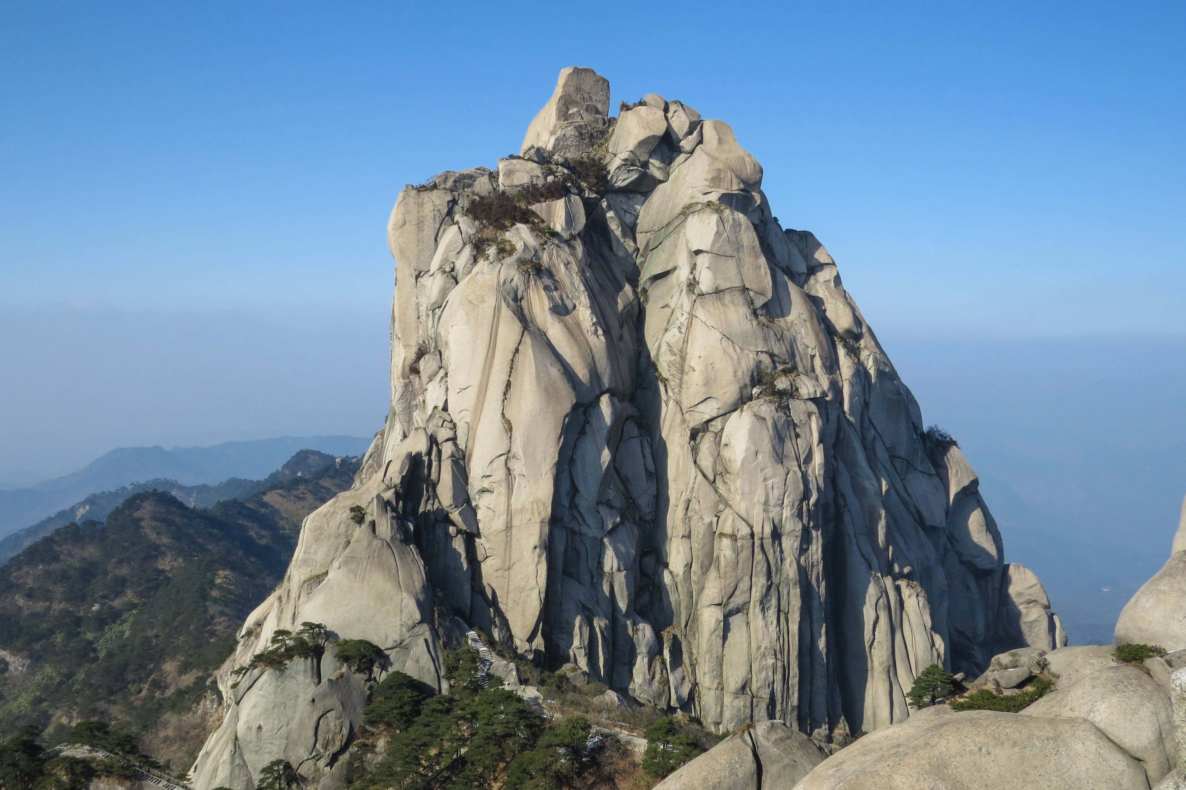
From the Xihe trailhead, the route climbs west on a stone-step path through dense forest, passing the Xihe waterfall (西河瀑布) and a series of pools at ~1,100 m. The trail crosses a small saddle at ~1,300 m and then climbs the south ridge to the Mao’er Stone (帽儿石) summit — a granite tor capped with a small viewing platform at 1,584 m, the highest point of the Dabie Mountains on the Henan side and the highest point of Shangcheng County. From the summit, the engineered ridge boardwalk continues briefly north toward the Jingangtai (金刚台) summit complex itself; the standard day-trip turns at Maoershi and descends the same line.
Why it is essential
This is the only true high-summit day on the Henan Dabie. Maoershi sits more than 700 m above the surrounding farmed valleys and gives the most open ridge view in the range — north to the Huai plain, south into the Anhui Jinzhai interior. The walking is genuine forest-trail-and-stair, not a paved tourist circuit, and the summit ridge has the geological exposure that earned Jingangtai its National Geopark designation. For walkers who want one summit in the Henan Dabie, it is the obvious choice.
Equipment
- Sturdy hiking shoes for stone steps and exposed summit rock
- Trekking poles for the descent
- Warm layer (summit temperatures 8–10 °C lower than the trailhead)
- Wind shell
- 2 L water (no resupply on the climb)
- Headlamp for a margin on shorter winter days
Hazards and notes
- Sustained stair descent is the main injury vector; trekking poles strongly recommended.
- Summit ridge is exposed to wind and lightning; descend immediately if storms develop.
- Mobile coverage on the upper ridge is intermittent.
- Scenic-area opening hours typically 08:00–17:00; entry after 14:00 is not advised.
- Light ice on the summit ridge from late November through February; microspikes useful.
4. Huangbaishan — Jiufengjian circuit
Snapshot
Itinerary
From the visitor centre, the loop heads south-east on a paved forest road past Xiaojiezi (小界子) and the Old Pine Hall (古松堂), then turns up a stone-step trail through dense old-growth pine and broadleaf forest. The trail climbs to Jiufengjian (九峰尖, “Nine-Peak Tip”, 1,352 m) — the tri-province corner where Henan (Shangcheng), Hubei (Macheng) and Anhui (Jinzhai) meet, marked by a stone boundary tablet. Return descends north-west along the secondary ridge, passes the Free-Cloud Pagoda (息影塔) commemorating the Ming-dynasty monk Wuyin who founded Huangbaishan’s Buddhist tradition, and rejoins the forest road back to the visitor centre.
Why it is essential
Huangbaishan is the deepest, least-engineered scenic area on the Henan Dabie, with 98% forest cover and one of the highest concentrations of old-growth pine in central China. The Jiufengjian tri-province corner — locally called Jīmíng Sānshěng (鸡鸣三省, “the cockerel’s crow heard in three provinces”) — is the only point on a marked Henan-side hike where a walker stands simultaneously on all three Dabie provinces. The forest character is closer to a North American national forest than to a typical Chinese 5A scenic area, and the walking is correspondingly more honest.
Equipment
- Sturdy hiking shoes
- Insect repellent and long sleeves (mosquitoes and ticks in summer)
- Rain shell
- 2 L water
- Light snack lunch (no facilities on the ridge)
- Trekking poles for the descent
Hazards and notes
- Trail signage is in Chinese only; carry an offline OSM track.
- Mobile coverage is patchy on the ridge.
- The forest understory is thick; do not leave the marked trail.
- Wild boar and serow are present but normally retreat; macaques are common around the visitor centre.
- The scenic area is open year-round; in winter the upper ridge can hold rime ice.
5. Jinlanshan — Jinlan and Xidashan ridge
Snapshot
Itinerary
From the front gate the cable car climbs to the Jinlanding (金兰顶, 768 m) summit ridge in about 12 minutes. From the upper station, the walking trail follows an engineered timber-and-stone boardwalk south along the Jinlan ridge past the Taoist Lingguan Pavilion (灵官殿) and the Three-Brother Caves (三圣洞), then crosses a saddle to climb Xidashan (西大山, ~720 m). From Xidashan a stone-step descent drops west through the Yunwan Forest (云湾林) past the Doumu Temple (斗姆宫) and rejoins the front-gate plaza.
Why it is essential
Jinlanshan is the cultural-religious anchor of the eastern Henan Dabie and the highest summit immediately accessible from Xinxian county town. It is one of the few Henan-side mountains with a continuous Daoist temple tradition, claimed as a regional centre of the Quanzhen school. As a hike it is short and easy, but the ridge geology — Sinian-era metamorphic exposure earning the National Geopark designation — and the Daoist cultural layer make it a complementary half-day to the longer summit pushes of Jingangtai and Huangbaishan.
Equipment
- Light hiking shoes
- Water and snack
- Sun protection
- Cash for cable car (separate ticket from scenic-area entry)
Hazards and notes
- Stone steps are slick in rain; the descent past Doumu Temple is the steepest section.
- Daoist temple festivals on the second and ninth lunar months bring heavy crowds.
- Cable car suspends in high wind; check operation at the front gate before relying on it for descent.
- Xinxian is the gateway town for the Eyuwan (鄂豫皖) Soviet Memorial sites; pairs naturally with a half-day cultural visit.
Routes excluded as out of scope
The following sit inside the Henan Dabie footprint but fall outside a day-hike entry, or duplicate routes covered on neighbouring sub-region pages.
- Tiantangzhai summit (1,729 m). The Henan-Hubei-Anhui border peak; covered in the Tiantangzhai and Hubei-side Dabie entry rather than here.
- Tongbai Mountains (桐柏山, 1,140 m). A separate range west of the Dabie watershed across the Tongbai-Dabie tectonic line; not part of the Dabie footprint despite editorial proximity.
- Mount Wugong (武功山) and other Jiangxi peaks. Frequently confused with Dabie destinations by aggregator sites; out of scope.
- Multi-day Dabieshan National Forest Trail (大别山国家森林步道) sections. The 840 km long-distance trail crosses Henan but is a multi-stage tramp, not a day-hike.
- Xinxian red-tourism circuit. The Eyuwan Soviet Memorial Park in Xinxian county town is a cultural half-day worth pairing with Jinlanshan but is not a hike.
External links
| Source | URL |
|---|---|
| Henan Provincial Department of Culture and Tourism | hct.henan.gov.cn |
| Xinyang municipal government — tourism | xinyang.gov.cn |
| Mount Jigong National Forest Park — official | jigongshan.com |
| Wikipedia — Jigongshan | en.wikipedia.org |
| Wikipedia — Dabie Mountains | en.wikipedia.org |
| Baidu Baike — Lingshan (灵山) | baike.baidu.com |
| Baidu Baike — Jingangtai (金刚台) | baike.baidu.com |
| Baidu Baike — Huangbaishan (黄柏山) | baike.baidu.com |
| Baidu Baike — Jinlanshan (金兰山) | baike.baidu.com |
| Shangcheng County government | shangcheng.gov.cn |
| Xinxian County government — Eyuwan Soviet memorials | xinxian.gov.cn |
| OpenStreetMap (ODbL 1.0) | openstreetmap.org |