Regional overview
Otira Valley is the west-facing alpine valley immediately beyond Arthur’s Pass summit, under the northern flank of Mount Rolleston/Kaimatau. It is one of the quickest places in Arthur’s Pass National Park to step from a highway car park into open Main Divide terrain: glacial moraine, tussock, subalpine scrub, rock, stream crossings, and avalanche paths.
The strict Otira Valley Track is short and ends at the Otira River footbridge. For a five-hike catalogue entry, the area is widened to include the adjacent Temple Basin/pass walks and the West Coast-side Kelly Creek tracks near Otira village. These are still part of the same SH73 Main Divide corridor, but they are not all in the named Otira Valley itself.
The normal walking season is summer and autumn. DOC warns of avalanche danger on the Otira Valley Track from May to November, with challenging avalanche terrain to the footbridge and complex terrain beyond it. The Kelly Creek tracks are also steep, rugged, wet-weather-sensitive West Coast routes.
Selection rationale
These five hikes cover the Otira-side day-walk set without inventing unofficial routes: the official Otira Valley footbridge walk, the adjacent Temple Basin and Dobson pass walks, and two longer West Coast-side Kelly Creek objectives, Carroll Hut and Hunts Creek Hut.
Summary table
| # | Hike | Country | Route type | Distance | Gain | Max elevation | Difficulty | Photo status |
|---|---|---|---|---|---|---|---|---|
| 1 | Otira Valley Track to Footbridge | New Zealand | Out-and-back | 3.4 km return by DOC doubled distance; 3.7 km by AllTrails | 181 m by AllTrails | 1,009 m by AllTrails | Advanced / moderate-hard | Commons image verified |
| 2 | Temple Basin Track to Lockwood Day Shelter | New Zealand | Out-and-back | 4.2 km return by DOC doubled distance; 5.3 km by AllTrails | 490 m by AllTrails | 1,369 m by AllTrails | Advanced / hard | Commons image verified |
| 3 | Dobson Nature Walk and Arthur’s Pass Lookout | New Zealand | Out-and-back / short interpretive walk | 750 m return by DOC; 1.8 km by AllTrails variant | 89 m by AllTrails | 945 m by AllTrails | Easy | No verified reusable specific image |
| 4 | Carroll Hut Track | New Zealand | Out-and-back | 5.0 km return by DOC; 5.6 km by AllTrails | 760-761 m | 1,109 m by AllTrails | Advanced / hard | No verified reusable specific image |
| 5 | Hunt Saddle Track to Hunts Creek Hut | New Zealand | Out-and-back | 13 km return | Advanced | No verified reusable specific image |
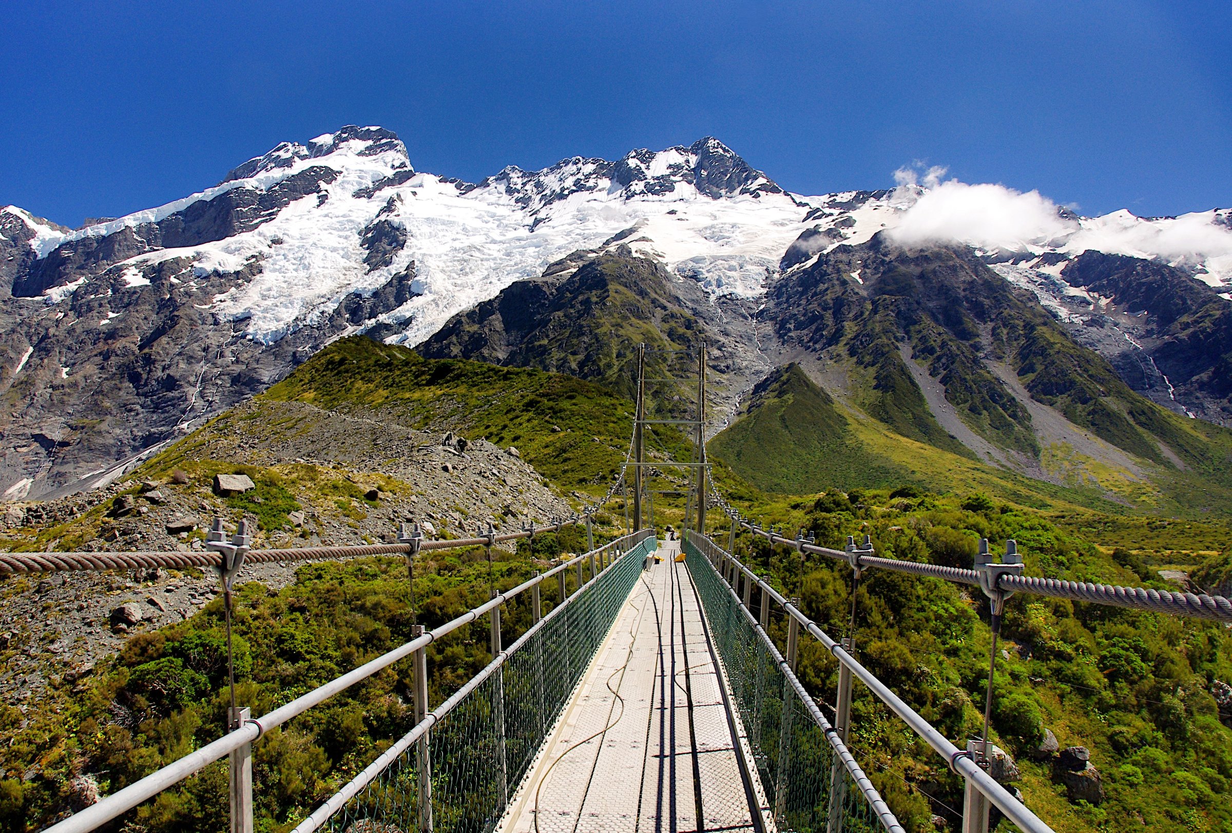
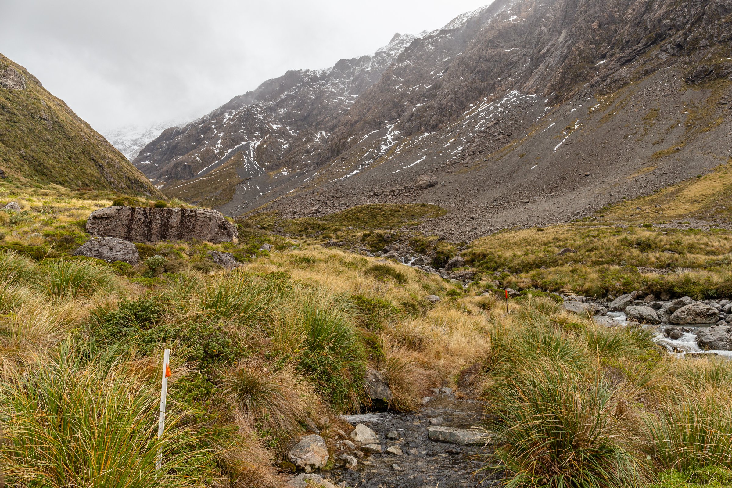
1. Otira Valley Track to Footbridge
Snapshot
Itinerary
From the roadside car park, the track climbs across old glacial moraine, then contours through subalpine scrub and tussock into the upper Otira Valley. The official route ends at the Otira River footbridge.
Return by the same route. Travel beyond the footbridge requires map reading, route-finding, and alpine tramping or mountaineering experience.
Why it is essential
This is the signature Otira Valley day walk: short, accessible, and immediately alpine, with close views into Mount Rolleston’s northern valley system.
Equipment
- Mountain hiking equipment: boots, waterproof shell, warm layer, food, water, sun protection, map/GPS, and navigation backup.
- Trekking poles are useful on rocks and small stream crossings.
- Snow-covered conditions require snow travel skills and avalanche judgement.
Hazards and notes
- DOC warns of challenging avalanche terrain to the footbridge and complex avalanche terrain beyond it.
- Avalanche danger is specifically noted from May to November.
- Good visibility is needed above the bushline.
- No dogs are allowed.
Photos
| Image | Source | Author | Licence | Reuse notes | Attribution |
|---|---|---|---|---|---|
| Otira Valley Track, Arthur’s Pass National Park 05 | commons.wikimedia.org | Michal Klajban | CC BY-SA 4.0 | Commercial reuse and modification appear allowed with attribution and share-alike | Michal Klajban, CC BY-SA 4.0, via Wikimedia Commons |
GPX / KML links
| Source | URL | Format | Licence / terms | Reuse status |
|---|---|---|---|---|
| DOC: Otira Valley Track | doc.govt.nz | Official route page / map | DOC website terms; no GPX found | Source-map reference only |
| OpenStreetMap relation: Otira Valley Track | openstreetmap.org | OSM route relation / source geometry | OSM data is ODbL | Geometry cross-check only; attribution required under ODbL |
| AllTrails: Otira Valley Track | alltrails.com | Route page / app map | AllTrails terms apply | Secondary source-map reference; GPX reuse not confirmed |
External links
2. Temple Basin Track to Lockwood Day Shelter
Snapshot
Itinerary
The track climbs steeply from the Temple Basin car park through open tussock to the ski-club buildings and Lockwood day shelter. Views open across the pass corridor toward Mount Rolleston and the Otira/Bealey divide.
The marked track ends at the shelter. Above it there is no marked route and DOC identifies complex avalanche terrain.
Why it is essential
Temple Basin is the companion alpine basin to Otira Valley on the same Main Divide road corridor. It gives a steeper, higher, more open day walk than the Otira footbridge track.
Equipment
- Mountain hiking equipment: boots, waterproof shell, warm layer, food, water, sun protection, map/GPS, and navigation backup.
- Trekking poles are useful for descent.
- In snow or ski-season conditions, check avalanche and ski-area information.
Hazards and notes
- Above-bushline weather exposure starts immediately.
- Ski-area avalanche control and closures may apply during the winter operating season.
- No dogs are allowed.
Photos
| Image | Source | Author | Licence | Reuse notes | Attribution |
|---|---|---|---|---|---|
| Templebasin.jpg | commons.wikimedia.org | Author not machine-readable on Commons | Public domain | Commercial reuse and modification appear allowed; attribution not required but source credit recommended | Public domain, via Wikimedia Commons |
GPX / KML links
| Source | URL | Format | Licence / terms | Reuse status |
|---|---|---|---|---|
| DOC: Temple Basin Track | doc.govt.nz | Official route page / map | DOC website terms; no GPX found | Source-map reference only |
| AllTrails: Temple Basin Track | alltrails.com | Route page / app map | AllTrails terms apply | Secondary source-map reference; GPX reuse not confirmed |
External links
3. Dobson Nature Walk and Arthur’s Pass Lookout
Snapshot
Itinerary
From Temple Basin car park, follow the interpretive track through subalpine and alpine plants to the Dobson Memorial side of the road. Return the same way.
Why it is essential
This is the easiest official walk at Arthur’s Pass summit and works as a short ecological and historical counterpart to the Otira Valley Track.
Equipment
- Standard hiking equipment: sturdy shoes, warm layer, raincoat, water, and sun protection.
- Extra warm clothing is sensible even on short stops at the pass.
Hazards and notes
- Take care crossing SH73.
- Wind, rain, and cold can arrive quickly.
- No dogs are allowed.
Photos
Photo status: No licence-compatible image fully verified in this pass. DOC lists a Dobson Nature Walk image by Nic Menary as Creative Commons, but the exact licence variant and direct image URL were not resolved.
| Image | Source | Author | Licence | Reuse notes | Attribution |
|---|---|---|---|---|---|
| Unresolved | Unresolved | Unresolved | Unresolved | No verified reusable specific photo candidate found | Unresolved |
GPX / KML links
| Source | URL | Format | Licence / terms | Reuse status |
|---|---|---|---|---|
| DOC: Dobson Nature Walk | doc.govt.nz | Official route page / map | DOC website terms; no GPX found | Source-map reference only |
| AllTrails: Dobson Nature Walk | alltrails.com | Route page / app map | AllTrails terms apply | Secondary source-map reference; GPX reuse not confirmed |
External links
4. Carroll Hut Track
Snapshot
Itinerary
From the SH73 gravel car park, cross the initial creek if safe, then climb steeply through rata/kamahi forest and subalpine scrub. The track reaches tussock grasslands around Carroll Hut on the Kelly Range, with views towards the Taramakau River on fine days.
Return by the same track. The optional side trip to Kellys Hill is unmarked and is only for experienced alpine trampers in good visibility.
Why it is essential
Carroll Hut Track is the classic steep West Coast-side day climb near Otira, giving a forest-to-tussock ascent and broad views without committing to a multi-day route.
Equipment
- Mountain hiking equipment: boots, waterproof shell, warm layers, food, water, map/GPS, navigation backup, and headtorch.
- Emergency shelter, spare food, first-aid kit, and distress beacon are recommended.
- Snow conditions require winter alpine equipment and avalanche assessment skills.
Hazards and notes
- The first creek crossing may be impossible after heavy rain.
- DOC warns the track is steep and rugged and that above-bushline travel requires navigation skills.
- Avalanche paths can cross the track in winter or snow conditions.
- Access from Carroll tops to Taipo Valley was noted by DOC as washed out in the lower Seven Mile Stream area; this does not affect the standard day return to Carroll Hut but matters for extensions.
- No dogs are allowed.
Photos
Photo status: No route-specific licence-compatible image found in this pass. DOC lists a Carroll Hut Track image by Ruth McKie as Creative Commons, but the exact licence variant and direct image URL were not resolved.
| Image | Source | Author | Licence | Reuse notes | Attribution |
|---|---|---|---|---|---|
| Unresolved | Unresolved | Unresolved | Unresolved | No verified reusable specific photo candidate found | Unresolved |
GPX / KML links
| Source | URL | Format | Licence / terms | Reuse status |
|---|---|---|---|---|
| DOC: Carroll Hut Track | doc.govt.nz | Official route page / map | DOC website terms; no GPX found | Source-map reference only |
| AllTrails: Carroll Hut Track | alltrails.com | Route page / app map | AllTrails terms apply | Secondary source-map reference; GPX reuse not confirmed |
External links
5. Hunt Saddle Track to Hunts Creek Hut
Snapshot
Itinerary
From Kelly Creek car park, follow Carroll Hut Track briefly, then turn onto the Hunt Saddle route on the true left of Kellys Creek. The track climbs above a gorged river section, drops back to the creek, follows riverbed sections, and climbs through light forest to Hunt Saddle. From the saddle, a rough track sidles above Hunts Creek, crosses large screes, and drops into the basin and tussock flat around Hunts Creek Hut.
Return by the same route. The day is long, rough, and weather-sensitive.
Why it is essential
Hunt Saddle is the longer West Coast-side counterpart to Carroll Hut: a full-day advanced tramp through gorge, creek, saddle, scree, and hut terrain from the Otira/Kelly Creek side of the Main Divide corridor.
Equipment
- Mountain hiking equipment: boots, waterproof shell, warm layers, food, water treatment, map/GPS, compass, headtorch, first aid, and navigation backup.
- Emergency shelter, spare food, and distress beacon are strongly recommended.
Hazards and notes
- Hunt Saddle is muddy, high-tussock terrain with navigation difficulty and deep holes.
- Riverbed and creek travel may be unsafe in rain or high flows.
- Scree crossings, rough sidles, cold weather, and delays are realistic hazards.
- Hut water is untreated and must be boiled or treated.
Photos
Photo status: No licence-compatible image found in this pass.
| Image | Source | Author | Licence | Reuse notes | Attribution |
|---|---|---|---|---|---|
| Unresolved | Unresolved | Unresolved | Unresolved | No verified reusable photo candidate found | Unresolved |
GPX / KML links
| Source | URL | Format | Licence / terms | Reuse status |
|---|---|---|---|---|
| DOC: Hunt Saddle Track to Hunts Creek Hut Track | doc.govt.nz | Official route page / map | DOC website terms; no GPX found | Source-map reference only |
External links
External links
| Source | URL |
|---|---|
| DOC — Otira Valley Track | doc.govt.nz |
| DOC — Temple Basin Track | doc.govt.nz |
| DOC — Dobson Nature Walk | doc.govt.nz |
| DOC — Carroll Hut Track | doc.govt.nz |
| DOC — Carroll Hut | doc.govt.nz |
| DOC — Hunt Saddle Track to Hunts Creek Hut Track | doc.govt.nz |
| AllTrails — Otira Valley Track | alltrails.com |
| AllTrails — Temple Basin Track | alltrails.com |
| AllTrails — Dobson Nature Walk | alltrails.com |
| AllTrails — Carroll Hut Track | alltrails.com |
| Temple Basin — Getting Here | templebasin.co.nz |