


Regional overview
The Vindhya, Satpura and Central Indian Highlands form a broad plateau-and-escarpment walking region rather than a single alpine range. The hiking character is forested sandstone and basalt hills, ravines, waterfalls, temple peaks, biosphere-reserve plateaux, and archaeological rock-shelter landscapes. Elevations are modest by Himalayan standards, but heat, monsoon water, slippery rock, wildlife areas, and regulated forest access matter.
The most established hill-walking centre is Pachmarhi, inside the Pachmarhi Biosphere Reserve / Satpura Tiger Reserve landscape. Amarkantak, at the meeting of the Vindhya, Satpura and Maikal hills, adds a sacred source-river and waterfall walk. Bhimbetka gives the Vindhyan sandstone cultural-landscape walk: it is short, but essential to the region’s human-history identity.
The normal walking season is post-monsoon to winter, roughly October to February, with waterfalls best after rain. Summer heat can be severe, and monsoon walking can mean leeches, slippery steps, swollen streams, and reduced visibility. Forest routes may require local entry tickets, guides, vehicles, or permission; current local rules should be checked before departure.
Selection rationale
These five hikes cover the region’s strongest day-hike identities: a Satpura temple summit, the highest Satpura viewpoint, a Pachmarhi waterfall walk, the Amarkantak Narmada-source waterfall trail, and the Bhimbetka rock-shelter landscape at the southern edge of the Vindhyas.
Summary table
| # | Hike | Country | Route type | Distance | Gain | Max elevation | Difficulty |
|---|---|---|---|---|---|---|---|
| 1 | Chauragarh Temple from Pachmarhi side | India | Out-and-back | 7.1 km | 405 m | ca. 1,330 m | Moderate |
| 2 | Dhupgarh from Pachmarhi | India | Out-and-back | 17.9 km | 490 m | 1,350-1,352 m | Hard |
| 3 | Bee Falls / Jamuna Prapat walk | India | Out-and-back | 5.8 km | 148 m | ca. 1,100 m | Moderate |
| 4 | Amarkantak: Narmada Udgam – Kapil Dhara – Dugdh Dhara | India | Out-and-back / road-and-path walk | ca. 8-12 km depending start | Low-moderate; unresolved | ca. 1,050 m | Easy-moderate |
| 5 | Bhimbetka Rock Shelters circuit | India | Out-and-back / site circuit | 2.6 km | 71 m | ca. 600 m | Easy |
1. Chauragarh Temple from Pachmarhi side

Snapshot
Itinerary
The route climbs from the Pachmarhi side towards Chauragarh, a hilltop Shiva temple approached by long stair and path sections through Satpura forest and viewpoints. MP Tourism describes the temple as being at 1,330 m with 1,380 steps. The upper section reaches the temple courtyard, where many tridents offered by pilgrims are stacked. The return follows the same route.
Why it is essential
Chauragarh is one of Pachmarhi’s defining hill walks: a summit viewpoint, a living pilgrimage route, and a strong expression of the Satpura plateau’s temple-peak walking culture.
Equipment
- Hiking shoes or boots
- Water (carry extra in warm weather)
- Food
- Sun protection
- Weatherproof layer in monsoon or winter
- Map/GPS
Hazards and notes
- Steps and rock can be slippery after rain.
- Festival periods, especially around Mahashivratri, can bring very heavy pilgrim traffic.
- Heat, monkeys near temples, and limited water on the climb should be expected.
GPX / KML links
| Source | URL | Format / access | Reuse status |
|---|---|---|---|
| AllTrails: Chauragarh | alltrails.com | Source route / app track | AllTrails terms apply; source route found; route-file reuse not confirmed |
| OpenStreetMap search: Chauragarh Pachmarhi | openstreetmap.org | Map source | OSM data is ODbL; geometry cross-check only |
External links
2. Dhupgarh from Pachmarhi

Snapshot
Itinerary
The full walking version leaves Pachmarhi and climbs through Satpura forest and plateau roads/tracks towards Dhupgarh, the highest point in the Satpura range and Madhya Pradesh. The viewpoint is especially associated with sunrise and sunset views over surrounding forested ridges. Many visitors drive most of the route; the catalogue route treats Dhupgarh as a long out-and-back walk where walking access is permitted.
Why it is essential
Dhupgarh is the region’s highest and most famous viewpoint. It represents the high Satpura plateau landscape and gives the clearest geographical anchor for Pachmarhi walking.
Equipment
- Sturdy shoes
- Water
- Food
- Sun protection
- Warm layer for dawn/sunset
- Rain layer in monsoon
- Map/GPS
- Headtorch if returning late
Hazards and notes
- Road traffic, late returns after sunset, heat, poor visibility in monsoon, and wildlife-area access rules are the main issues.
- Confirm whether walking the full approach is allowed at the time of visit; some visitors may need a registered local vehicle for protected-area access.
GPX / KML links
| Source | URL | Format / access | Reuse status |
|---|---|---|---|
| AllTrails: Dhupgarh | alltrails.com | Source route / app track | AllTrails terms apply; source route found; route-file reuse not confirmed |
| OpenStreetMap search: Dhupgarh Pachmarhi | openstreetmap.org | Map source | OSM data is ODbL; geometry cross-check only |
External links
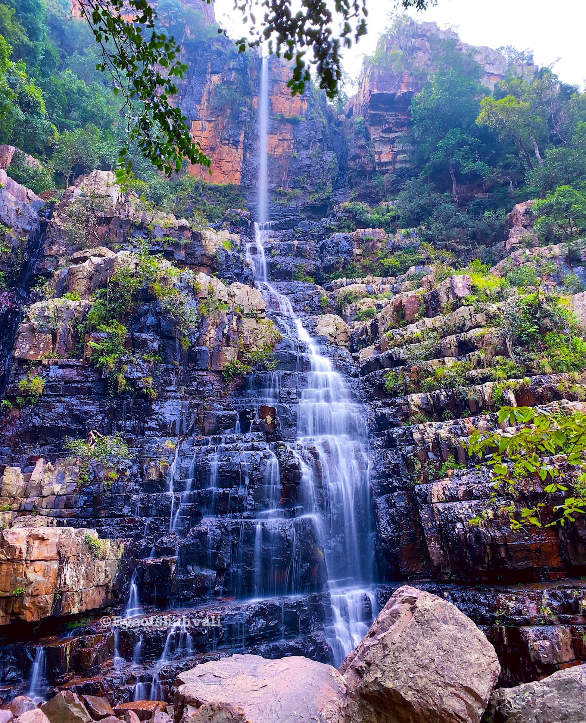
3. Bee Falls / Jamuna Prapat walk

Snapshot
Itinerary
The route follows the established Pachmarhi waterfall access path to Bee Falls, also called Jamuna Prapat. MP Tourism describes Bee Falls as about 5 km from the Pachmarhi bus stand and as a 150-foot waterfall. The walking route descends through forested ground and built steps to the falls, then returns by the same route.
Why it is essential
Bee Falls is one of Pachmarhi’s classic short walks and gives the catalogue a waterfall route that is highly representative of the Satpura plateau after the monsoon.
Equipment
- Grippy shoes
- Water
- Sun protection
- Rain layer in wet weather
- Dry bag for phone/camera near spray
- Trekking poles useful on wet steps
Hazards and notes
- Wet steps and polished rock can be slippery.
- Water levels rise after heavy rain.
- Crowding is common in holiday periods.
- Follow any local bathing restrictions and do not climb wet rock around the falls.
GPX / KML links
| Source | URL | Format / access | Reuse status |
|---|---|---|---|
| AllTrails: Bee Falls | alltrails.com | Source route / app track | AllTrails terms apply; source route found; route-file reuse not confirmed |
| OpenStreetMap search: Bee Falls Pachmarhi | openstreetmap.org | Map source | OSM data is ODbL; geometry cross-check only |
External links
4. Amarkantak — Narmada Udgam, Kapil Dhara and Dugdh Dhara
Snapshot
Itinerary
The route starts at the Narmada Udgam Temple area and follows local roads and paths towards Kapil Dhara, where the Narmada drops over a rocky waterfall. From Kapil Dhara, MP Tourism describes a one-kilometre trek to Dugdh Dhara, a second Narmada waterfall reached by rocky steps and wild bushes. The return follows the same line back to Amarkantak town, with optional short detours to temple and source-river sites.
Why it is essential
Amarkantak is described by MP Tourism as the meeting point of the Vindhya, Maikal and Satpura ranges and the source of the Narmada. This walk gives the region an eastern highland, sacred-river and waterfall entry rather than another Pachmarhi-only route.
Equipment
- Walking shoes
- Water
- Sun protection
- Light rain layer in monsoon
- Map/offline navigation
- Modest clothing for temple areas
Hazards and notes
- The exact walking geometry is not strongly published as a GPS route. Use local advice to confirm safe pedestrian links, especially in monsoon.
- Steps around waterfalls can be slippery, and stream edges should be avoided during high water.
GPX / KML links
| Source | URL | Format / access | Reuse status |
|---|---|---|---|
| MP Tourism: Amarkantak | mptourism.com | Official source page | Website terms not fully checked; route description checked; no GPX |
| OpenStreetMap search: Kapil Dhara Amarkantak | openstreetmap.org | Map source | OSM data is ODbL; manual GPX creation possible after geometry check |
External links
5. Bhimbetka Rock Shelters circuit

Snapshot
Itinerary
The walking circuit follows the managed visitor route through sandstone shelters and rock-painting sites at Bhimbetka. UNESCO and MP Tourism identify Bhimbetka as a major prehistoric rock-shelter landscape, with hundreds of shelters distributed over the hills. The route is short and partly paved or stepped, but the terrain is still a hill walk through boulder and forest scenery.
Why it is essential
Bhimbetka is not a long mountain hike, but it is essential to the Vindhyan part of the region. It links sandstone landform, forested hills and one of India’s most important prehistoric cultural landscapes.
Equipment
- Comfortable shoes
- Water
- Sun protection
- Modest clothing for a protected archaeological site
Hazards and notes
- Stay on the marked visitor path and do not touch rock art.
- Summer heat is the main physical issue.
- Some shelters or paths may be closed for conservation or maintenance.
GPX / KML links
| Source | URL | Format / access | Reuse status |
|---|---|---|---|
| AllTrails: Bhimbetka Rock Shelters | alltrails.com | Source route / app track | AllTrails terms apply; source route found; route-file reuse not confirmed |
| UNESCO World Heritage: Rock Shelters of Bhimbetka | whc.unesco.org | Protected-area/source page | UNESCO website terms apply; site verification; no GPX |
| OpenStreetMap search: Bhimbetka Rock Shelters | openstreetmap.org | Map source | OSM data is ODbL; geometry cross-check only |
External links
- MP Tourism — Bhimbetka
- UNESCO World Heritage Centre — Rock Shelters of Bhimbetka
- AllTrails — Bhimbetka Rock Shelters
- Wikimedia Commons — Rock Shelter 8, Bhimbetka 02
Missing data / follow-up work
- Amarkantak needs a GPS-grade route trace and elevation profile; only the Kapil Dhara to Dugdh Dhara one-kilometre segment is strongly confirmed from MP Tourism.
- No licence-compatible Amarkantak image was verified in this pass.
- Dhupgarh walking access should be locally confirmed because many visitors use vehicles and protected-area rules can change.
- Pachmarhi route access may depend on local permits, forest vehicles or seasonal restrictions.
- Elevation maximums for Bee Falls and Bhimbetka are approximate and should be backfilled from GIS.
External links
| Source | URL |
|---|---|
| MP Tourism — Pachmarhi | mptourism.com |
| MP Tourism — Amarkantak | mptourism.com |
| MP Tourism — Bhimbetka | mptourism.com |
| UNESCO World Heritage Centre — Rock Shelters of Bhimbetka | whc.unesco.org |
| AllTrails — Chauragarh | alltrails.com |
| AllTrails — Dhupgarh | alltrails.com |
| AllTrails — Bee Falls | alltrails.com |
| AllTrails — Bhimbetka Rock Shelters | alltrails.com |