Regional overview
The Chinese and Kazakh Altai form a cold, continental mountain borderland of taiga forest, glacial lakes, granite gorges, high meadows, Tuva and Kazakh villages, and long winter snow cover. In China, the best-known hiking areas are the Kanas-Hemu-Baihaba landscape in Altay Prefecture and the Keketuohai UNESCO Global Geopark in Fuyun County. Across the border in Kazakhstan, Katon-Karagay National Park protects the southern Altai around Lake Yazevoe, Rakhmanov Springs, and distant views towards Belukha.
Walking in the Chinese scenic areas is often managed through ticketed gates, mandatory shuttle buses, fixed viewpoints, boardwalks, and seasonal access controls rather than open backcountry trailheads. The Kazakh Altai is more remote: national-park registration, border-zone documents, guides, and vehicle logistics may be required. Summer and early autumn are the normal hiking seasons; snow, avalanche terrain, closed roads, river crossings, and very low temperatures can affect the region outside that window.
Selection rationale
The five hikes below cover the region’s key walking characters: the iconic Kanas Lake panorama, the Kanas River “Three Bays” boardwalk, the Hemu village-and-forest viewpoint landscape, the granite gorge of Keketuohai, and a Kazakh Altai Belukha-view walking target. The route-stat evidence is uneven. Park and tourism sources verify the landmarks and access pattern, while exact GPX-grade walking statistics remain unresolved for several managed scenic-area paths.
Summary table
| # | Hike | Country | Route type | Distance | Elevation gain | Max elevation | Difficulty |
|---|---|---|---|---|---|---|---|
| 1 | Kanas Lake Fish-Viewing Pavilion | China | Out-and-back / shuttle-assisted viewpoint walk | About 3–5 km if walked from lakeside; shorter with shuttle | 300–650 m depending on start | 2,030 m | Moderate–hard |
| 2 | Kanas Three Bays: Fairy Bay, Moon Bay, Wolong Bay | China | One-way boardwalk / shuttle-assisted linear walk | About 5–7 km; exact walking line unresolved | Minor | About 1,250–1,400 m | Easy–moderate |
| 3 | Hemu Village Viewing Platform and Birch Forest Walk | China | Loop / out-and-back variants | About 2–5 km | About 80–200 m | Easy–moderate | |
| 4 | Keketuohai Irtysh Grand Canyon: Shenzhong Mountain to Jiland Hot Spring | China | Linear scenic-road / canyon walk | About 7 km for the Shenzhong Mountain–Jiland Hot Spring section | 1,359 m at Shenzhong Mountain | Moderate | |
| 5 | Lake Yazevoe / Rakhmanov Springs Belukha-View Walk | Kazakhstan | Out-and-back / short local circuit variants | Candidate only |
Before you go
Permits and access
Four of the five hikes are inside managed Chinese scenic areas. Kanas Lake, the Three Bays, and Hemu sit inside the Kanas Scenic Area in Burqin County, where access is controlled through ticketed gates, mandatory shuttle buses, fixed viewpoints, and seasonal opening rules. Keketuohai is managed as a UNESCO Global Geopark in Fuyun County, with its own internal scenic transport and access corridor between Shenzhong Mountain and Jiland Hot Spring. The fifth hike is in Katon-Karagay National Park in East Kazakhstan, where national-park registration, border-zone documents, guides, and arranged vehicle transfers may be required. Current ticketing, shuttle rules, opening times, and pedestrian access patterns must be checked locally before relying on any walking line.
Standard Altai day-hiking kit
For all five routes, carry:
- Mountain walking equipment: hiking shoes or light boots, waterproof/windproof jacket, warm layer, food, water, sun protection, headlamp, first-aid kit, and navigation backup.
- Gloves and a warm hat for autumn and early winter days.
- Traction or microspikes for icy boardwalks, steps, and scenic-road sections outside summer.
- Insect protection for the Kazakh Altai variant.
- Identity documents and any required Katon-Karagay/border-zone permits for the Kazakhstan hike.
Common hazards
Across all five routes, weather can change quickly, and snow or ice can affect steps, boardwalks, and scenic roads outside summer. Scenic-area transport, tickets, opening times, and pedestrian access may change seasonally — do not assume that informal hillside shortcuts are legal. Rockfall-prone cliffs, icy paths, and river-edge exposure are realistic concerns in Keketuohai. For the Kazakh hike, border-zone rules, permit checks, limited rescue, rough roads, wildlife, cold storms, river crossings on extended routes, and language/logistics barriers are the major issues.
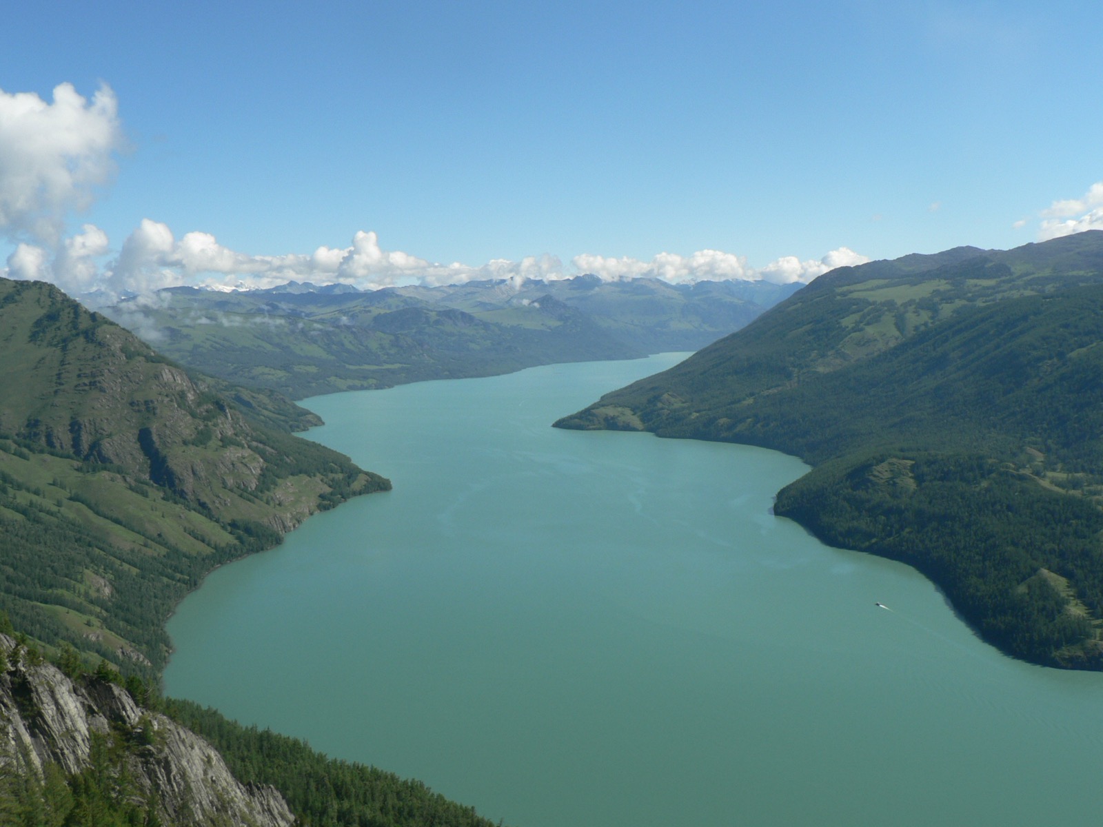
1. Kanas Lake Fish-Viewing Pavilion
Snapshot
Itinerary
The normal objective is the ridge-top Fish-Viewing Pavilion above the west side of Kanas Lake. From the lower scenic area, visitors either climb the stair-and-path approach or use the park shuttle to shorten the ascent, then finish on foot to the viewing platforms. The reward is the classic full-length view over Kanas Lake, the forested valley, and the Altai ridges beyond.
The walking-only route length is not consistently published in English sources because the park visit is usually described as a shuttle-and-viewpoint itinerary. The vertical relationship is better verified: Kanas Lake is widely cited around 1,374 m, while the Fish-Viewing Pavilion is cited at 2,030 m.
Why it is essential
This is the defining Kanas panorama and the most recognisable viewpoint in the Chinese Altai. It shows the lake’s glacial valley setting, the taiga forest belt, and the borderland mountain landscape in a single view.
Hazards and notes
- Weather can change quickly, and snow or ice can affect steps outside summer.
- Scenic-area transport, tickets, opening times, and pedestrian access may change seasonally.
- Do not assume that informal hillside shortcuts are legal.
GPX / KML links
| Source | URL | Format | Notes |
|---|---|---|---|
| OpenStreetMap search: Kanas Lake Fish Viewing Pavilion | openstreetmap.org | Map/search | OSM data is ODbL; geometry cross-check only |
| China Discovery: Kanas Lake guide | chinadiscovery.com | Source page / attraction guide | Landmark and elevation cross-check only |
| Into Travel China: Kanas Lake itinerary | insights.intotravelchina.com | Source page / itinerary | Access and timing cross-check only |
External links
- China Discovery Kanas Lake and Fish-Viewing Pavilion overview
- Into Travel China Kanas Lake itinerary and Fish-Viewing Pavilion elevation
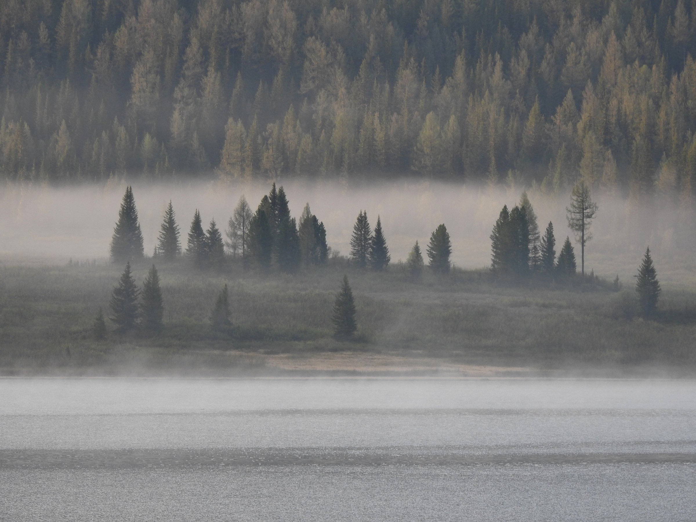
2. Kanas Three Bays: Fairy Bay, Moon Bay, Wolong Bay
Snapshot
Itinerary
The walk links the three classic lower Kanas River viewpoints: Fairy Bay, Moon Bay, and Wolong Bay. The path and boardwalk sections stay close to the river, alternating between open water views, bends in the river, wetland edges, and forest. Many visitors walk only selected sections and use the shuttle bus between stops; the most consistently sourced individual segment is Moon Bay to Wolong Bay, about 1.5 km.
Why it is essential
The Three Bays are the most accessible way to experience the Kanas River landscape on foot. They give the catalogue a lower-valley river walk to balance the high Fish-Viewing Pavilion panorama.
Hazards and notes
- Crowding, shuttle timing, slippery boardwalks after rain or frost, and cold wind in autumn are the main concerns.
- Stay on constructed paths to protect wetland and river-edge vegetation.
GPX / KML links
| Source | URL | Format | Notes |
|---|---|---|---|
| OpenStreetMap search: Kanas Three Bays | openstreetmap.org | Map/search | OSM data is ODbL; geometry cross-check only |
| China Discovery: Kanas Lake guide | chinadiscovery.com | Source page / attraction guide | Route-segment cross-check only |
| Into Travel China: Kanas Lake itinerary | insights.intotravelchina.com | Source page / itinerary | Timing/access cross-check only |
External links
- China Discovery Kanas Lake guide including Moon Bay and Wolong Bay walking distance
- Into Travel China Kanas one-day itinerary including Three Bays timing
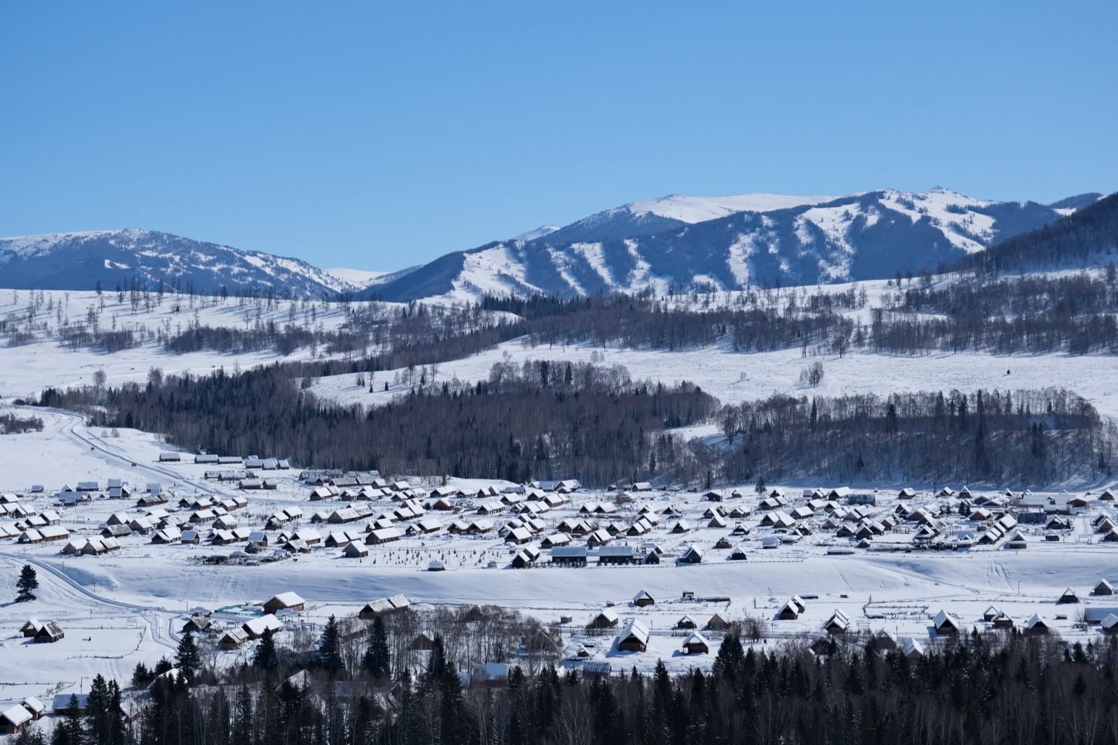
3. Hemu Village Viewing Platform and Birch Forest Walk
Snapshot
Itinerary
From Hemu Village, cross the Hemu River bridge used by visitors to reach the hillside viewing platform. The short climb gives the classic view over wooden Tuva-style houses, the river, birch forest, meadows, and surrounding ridges. A longer version continues through village lanes and nearby birch-forest paths before returning to the bridge and village.
Exact GPS distance varies because visitors combine the viewpoint, village lanes, riverbank, and forest edges in different ways. Multiple travel sources verify the bridge-to-viewing-platform pattern, but no licence-clear GPX route was found in this pass.
Why it is essential
Hemu is the best-known settlement walk in the Chinese Altai: a cultural landscape of Tuva/Kazakh village life, river meadow, birch forest, and snowy mountain backdrop.
Hazards and notes
- Winter visits require serious cold-weather clothing and traction if paths are icy.
- Sunrise walks are popular; use established paths and respect village privacy.
- Tourist reception, scenic-bus times, and accommodation availability are seasonal.
GPX / KML links
| Source | URL | Format | Notes |
|---|---|---|---|
| OpenStreetMap search: Hemu Village viewing platform | openstreetmap.org | Map/search | OSM data is ODbL; geometry cross-check only |
| Xinjiang Travel: Hemu Village | xinjiangtravel.org | Source page / attraction guide | Access and landmark verification only |
| TravelChinaGuide: Hemu Village | travelchinaguide.com | Source page / access guide | Access cross-check only |
External links
4. Keketuohai Irtysh Grand Canyon: Shenzhong Mountain to Jiland Hot Spring
Snapshot
Itinerary
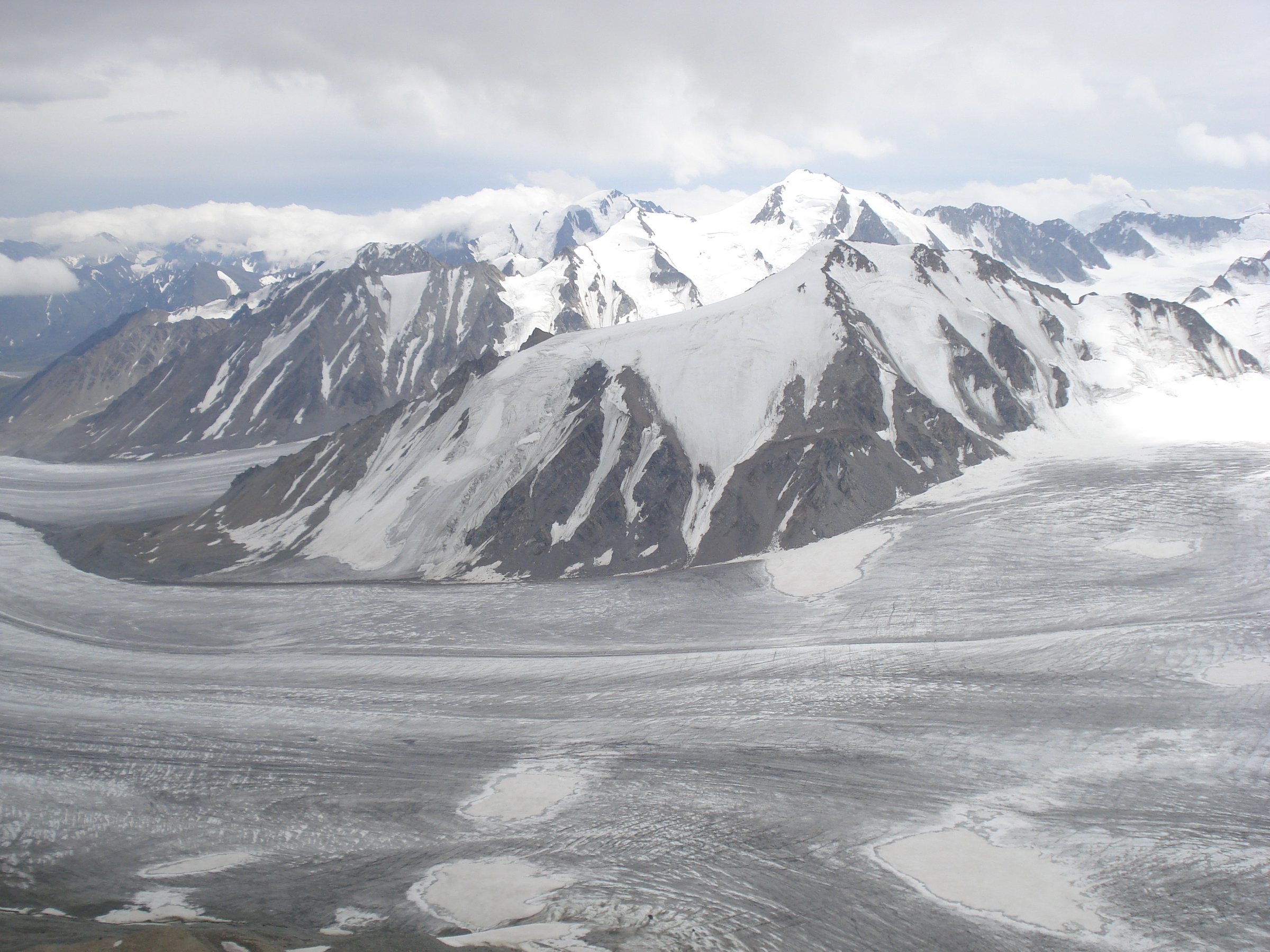
The walk follows the core scenic part of the Irtysh Grand Canyon, using the managed scenic road/path corridor between granite peaks, river bends, birch and pine forest, and the landmark Shenzhong Mountain. The official geopark page verifies the Irtysh Grand Canyon setting, Holy Bell Peak altitude, and granite landforms; a recent guide describes the 7 km road section from Shenzhong Mountain to Jiland Hot Spring.
Why it is essential
Keketuohai adds a very different Altai landscape from Kanas: granite domes, narrow river canyon, mining/geopark history, and the headwaters landscape of the Irtysh system.
Hazards and notes
- Rockfall-prone cliffs, icy paths, river-edge exposure, and closed scenic sections are possible.
- Do not leave the managed access corridor unless current park rules explicitly allow it.
GPX / KML links
| Source | URL | Format | Notes |
|---|---|---|---|
| OpenStreetMap search: Keketuohai Irtysh Grand Canyon | openstreetmap.org | Map/search | OSM data is ODbL; geometry cross-check only |
| Keketuohai UNESCO Global Geopark: Irtysh Grand Canyon | keketuohaigeopark.com | Official geopark source page | Landmark and canyon verification only |
| ChinaAdventure: Keketuohai guide | chinaadventure.org | Source page / guide | 7 km scenic-road section cross-check only |
External links
- Keketuohai UNESCO Global Geopark “The Irtysh Grand Canyon”
- Keketuohai UNESCO Global Geopark “Explore the Irtysh Grand Canyon”
- ChinaAdventure Keketuohai travel guide with 7 km Shenzhong Mountain–Jiland Hot Spring section
5. Lake Yazevoe / Rakhmanov Springs Belukha-View Walk
Snapshot
Itinerary
The publication-ready route line was not verified in this pass. The selected target is a short day walk around Lake Yazevoe or the Rakhmanov Springs area to gain views towards Belukha and the southern Altai. QazTravel and Katon-Karagay tourism sources verify the importance of the area, Belukha views, waterfalls, lakes, and protected-area character, but the reliable day-walk distance, gain, and downloadable route file remain unresolved.
Extended Belukha approaches from this area are multi-day horse or foot treks and should not be substituted for a day-hike entry without a clearly bounded route.
Why it is essential
This is the Kazakh Altai representative in the selection: remote southern Altai lakes, protected-area forest, and the cultural and scenic pull of Belukha, the highest Altai summit.
Hazards and notes
- Border-zone rules, permit checks, and limited rescue are the major issues.
- Rough roads, wildlife, cold storms, and river crossings on extended routes can all turn the day serious.
- Language and logistics barriers should be addressed via local national-park advice before committing to any independent route.
GPX / KML links
| Source | URL | Format | Notes |
|---|---|---|---|
| OpenStreetMap search: Lake Yazevoe Katon-Karagay | openstreetmap.org | Map/search | OSM data is ODbL; geometry cross-check only |
| QazTravel: Katon-Karagay waterfalls and Belukha-view routes | qaztravel.kz | Official tourism source page | Landmark and route-context verification only |
| Welcome.kz: Lake Yazevoe | welcome.kz | Source page / guide | Access/context verification only |
External links
- QazTravel “The Land of Waterfalls: Katon-Karagay National Park”
- Katon-Karagay tourism nature overview
- Welcome.kz Lake Yazevoe information
- Belukha.kz route context for longer Belukha approaches
External links
| Source | URL |
|---|---|
| China Discovery Kanas Lake guide | chinadiscovery.com |
| Into Travel China Kanas Lake itinerary | insights.intotravelchina.com |
| Xinjiang Travel Hemu Village | xinjiangtravel.org |
| TravelChinaGuide Hemu Village | travelchinaguide.com |
| Keketuohai UNESCO Global Geopark Irtysh Grand Canyon | keketuohaigeopark.com |
| Keketuohai UNESCO Global Geopark Explore the Irtysh Grand Canyon | keketuohaigeopark.com |
| ChinaAdventure Keketuohai guide | chinaadventure.org |
| QazTravel Katon-Karagay National Park | qaztravel.kz |
| Katon-Karagay tourism | katon-karagay.com |
| Welcome.kz Lake Yazevoe | welcome.kz |
| Belukha.kz Belukha route context | beluha.kz |