Regional overview
Keketuohai (可可托海, Koktokay in Kazakh) sits on the southern slope of the Chinese Altai in Fuyun County, Altay Prefecture, north-eastern Xinjiang. The wider Keketuohai UNESCO Global Geopark covers about 2,337 km² between 1,072 m and 3,234 m, taking in the granite peaks of the Irtysh Grand Canyon, the cold birch-and-pine forests of Shuimo Valley, the lake basin of Yileimu Hu, the surface rupture of the 1931 Fuyun earthquake on the Kalaxianger fault, and the No.3 rare-metal pegmatite open pit at the historic mining town. The Irtysh (Ertix) River rises in the canyon and flows north-west across Kazakhstan and Russia to the Arctic — the only river in China that drains to the Arctic Ocean.
Walking here is mostly scenic-area based rather than open-trail based. The five accessible day-walk landscapes — the Irtysh Grand Canyon, Shuimo Valley and White Birch Woods, Yileimu Lake, the Fuyun / Kalaxianger earthquake-remains area and the No.3 Mine and geology museum — are reached through ticketed gates and a network of internal shuttle buses centred on the geopark visitor area at Keketuohai town (1,200 m). The defining landscape is the 90 km Irtysh Grand Canyon between Keketuohai town and the upper headwaters: a granite gorge of domes, bell- and taper-shaped peaks rising 200–400 m above the river, often compared in Chinese tourism material to Yosemite. The walking footprint inside the canyon is limited to short signed sectors at named viewpoints; the full canyon is not a single day-walk.
Operating reality is dominated by the geopark ticketing and shuttle regime, cold continental weather and short summers. June to early September is the most reliable walking window; late September gives autumn birch and poplar colour in Shuimo Valley but is short and can end abruptly in early snow. The geopark records mean January temperatures below −20 °C and Fuyun has held a national low of −51.5 °C — winter walks should be treated as cold-weather days rather than ordinary hikes. Internal shuttle routes, viewpoint access and individual ticket bundling change year-on-year; the Keketuohai Geopark Administration in Keketuohai town is the current authority for what is open on any given day. Keketuohai is the eastern, geological end of a Chinese Altai walking region that also includes the Kanas Lake scenic area and the Hemu and Baihaba village valleys further west.
Selection rationale
The five walks below represent the geopark’s essential landscapes rather than its longest possible routes. Hike 1 covers the iconic granite canyon of the Irtysh, the geopark’s defining feature. Hike 2 gives the forest-and-stream counterpart in Shuimo Valley and White Birch Woods. Hike 3 reaches the major lake landscape at Yileimu. Hike 4 covers the tectonic heritage of the 1931 Fuyun earthquake rupture — the feature that secured Keketuohai’s UNESCO global geopark designation. Hike 5 closes the loop with the cultural-geology circuit at the No.3 Mine pit and the geology museum. Three of the five are partially verified from official geopark and tourism sources; two (Yileimu Lake and the earthquake rupture) remain candidate-only because the on-the-ground walking line is not formally published and reused trip reports are sparse.
No official GPX or KML downloads were found for any walk in this catalogue. The Keketuohai Geopark official site publishes attraction descriptions but no machine-readable route files; the Fuyun county tourism office publishes maps only. OpenStreetMap geometry exists for the main road, the canyon-side path and the principal scenic-area access points but not for the individual viewpoint spurs.
Summary table
| # | Hike | Country | Route type | Distance | Gain | Max elevation | Difficulty |
|---|---|---|---|---|---|---|---|
| 1 | Irtysh Grand Canyon — Shenzhong Mountain to Jiland Hot Spring | China | Shuttle-assisted linear scenic-road walk | ~7 km on the headline section | ~150–250 m | ~1,360 m at Shenzhong Mountain | Easy–moderate |
| 2 | Shuimo Valley and White Birch Woods | China | Out-and-back / short loop on signed paths | ~3–5 km | <100 m | ~1,250 m | Easy |
| 3 | Yileimu Lake shore and viewpoint walk | China | Short out-and-back on the western shore | ~2–4 km | <80 m | ~1,400 m | Easy |
| 4 | Fuyun / Kalaxianger earthquake rupture interpretive walk | China | Short out-and-back on signed interpretive path | ~2–4 km | <60 m | ~1,500 m | Easy |
| 5 | No.3 Mine pit and geology museum circuit | China | Short loop linking pit-rim viewpoint and museum | ~2–3 km | <80 m | ~1,250 m at the pit rim | Easy |
Before you go
Permits and access
All five walks lie inside the ticketed Keketuohai UNESCO Global Geopark and use the official entrance at the visitor centre in Keketuohai town. A single combined geopark ticket covers entry to the main scenic area (Irtysh Grand Canyon, Shuimo Valley / White Birch Woods, Yileimu Lake and the No.3 Mine pit); the Fuyun earthquake-remains area is a separate ticketed site reached by road from Keketuohai town. Internal access is by mandatory scenic shuttle bus on the canyon corridor — independent driving on the scenic road is not normally permitted. Ticket prices, shuttle stops, opening hours and which sectors are open change seasonally and should be confirmed with the Keketuohai Geopark Administration on arrival.
Standard Keketuohai day-walk kit
For all five walks, carry:
- Standard hiking equipment: walking shoes with grip, weatherproof and windproof shell, warm mid-layer, food, water, sun protection and a navigation backup.
- Hat and gloves outside midsummer; the canyon and lakeshore stay cold into June.
- Microspikes or light traction for icy boardwalks and stair sections in spring, autumn and winter.
- Insect protection in July and August in Shuimo Valley.
- Identity documents — the geopark gate and the earthquake-remains site both require ID for ticket issue.
Common hazards
Weather changes quickly in the canyon and at the lake; afternoon storms develop in July and August and snow can arrive at the canyon viewpoints from late September. Boardwalks, stair sections and pit-rim platforms become slippery after rain and frost; shuttle service is reduced or suspended in storms. Drone use inside the geopark is restricted and requires advance permission. Climbing on the granite domes, scrambling on the canyon walls and leaving signed paths inside the No.3 Mine pit area are prohibited.
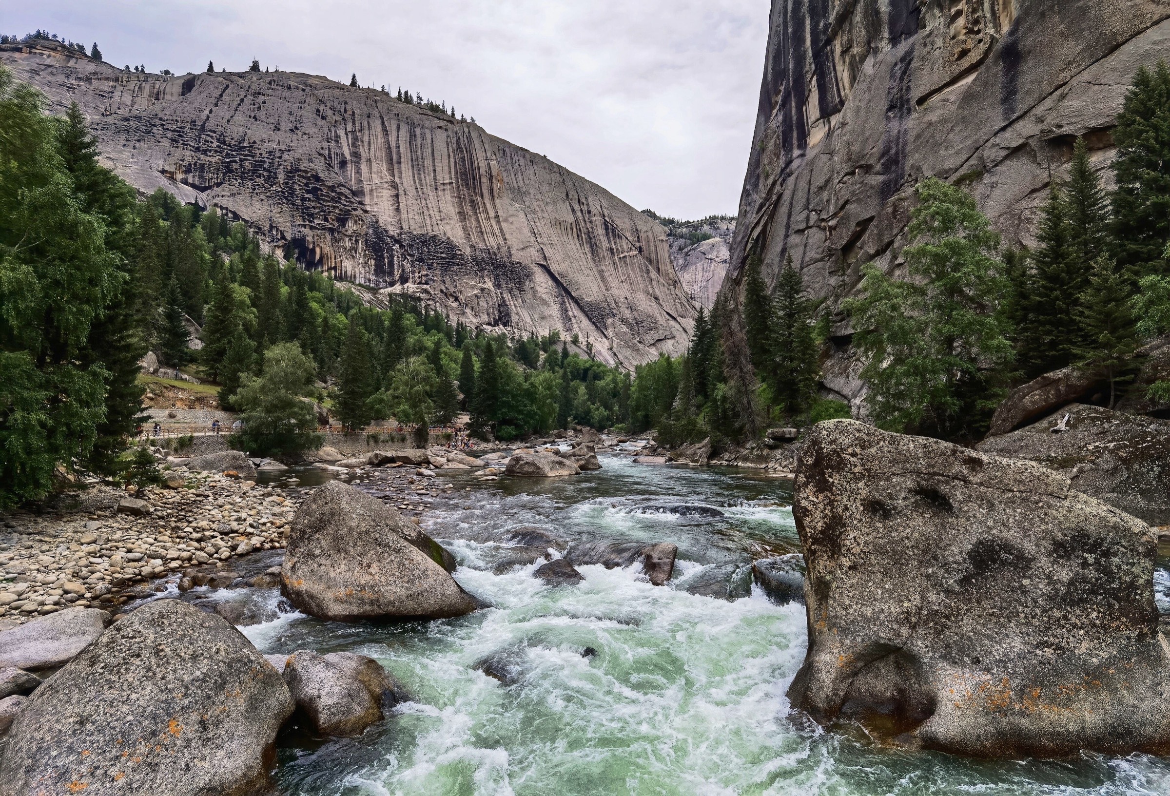
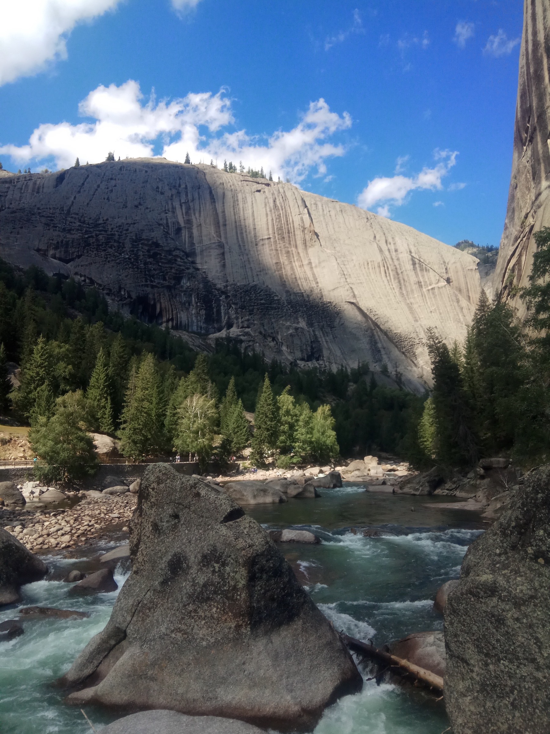
1. Irtysh Grand Canyon — Shenzhong Mountain to Jiland Hot Spring — 额尔齐斯大峡谷
Snapshot
Itinerary
The walk follows the canyon scenic road downstream from the Shenzhong Mountain shuttle stop to the Jiland Hot Spring terminus, with foot spurs at the named viewpoints along the way. The opening viewpoint is the Shenzhong Mountain (神钟山, “Holy Bell Peak”), a 1,360 m bell-shaped granite dome rising directly above the road and the canonical canyon image. The path then drops to river level along the scenic road, passes the Stone Bell and Camel Peak viewpoints, and runs alongside the Irtysh through a forested gorge of pine, larch and birch with granite walls 200–400 m high on each side. A short bridge crosses the river to a foot spur at the Wild Grape Ridge before the road climbs gently to the Jiland Hot Spring sector at the western end of the open scenic area.
Most visitors break the walk with the internal shuttle bus, riding between viewpoint stops and walking only the headline sectors. A practical day-walk takes the bus to Shenzhong Mountain at opening, walks the canyon corridor downstream over 7 km and returns from Jiland by shuttle. The opposite direction (uphill from Jiland) is also viable but loses the framing view of Shenzhong Mountain on the approach.
Why it is essential
The Irtysh Grand Canyon is the defining landscape of the Keketuohai geopark and the most photographed granite gorge in Xinjiang. The Shenzhong Mountain viewpoint, the river-level corridor and the Jiland Hot Spring sector together give the canyon’s full character on a single day. It is the route most directly tied to the geopark’s UNESCO designation for granite geomorphology.
Hazards and notes
- Rockfall is a real hazard on the scenic road after rain and during spring thaw; stay clear of the cliff base in poor weather.
- The canyon stays cold and shaded; midsummer mornings can be below 5 °C at Shenzhong Mountain.
- Stair sections at the viewpoint spurs are slippery after frost and rain.
- Shuttle service is reduced in storms and ends earlier than the gate closing time — check the last shuttle on arrival.
- Drone use over the canyon is restricted and requires advance permission from the geopark administration.
GPX / KML links
| Source | URL | Format | Notes |
|---|---|---|---|
| OpenStreetMap search: Irtysh Grand Canyon Keketuohai | openstreetmap.org | Map / search | OSM data is ODbL; geometry cross-check only |
| Keketuohai UNESCO Global Geopark — Irtysh Grand Canyon | keketuohaigeopark.com | Source page | Landmark and geology verification; no GPX |
| ChinaAdventure: Keketuohai guide | chinaadventure.org | Source guide | 7 km Shenzhong Mountain–Jiland Hot Spring section cross-check |
Further reading
- Keketuohai UNESCO Global Geopark — The Irtysh Grand Canyon
- UNESCO — Keketuohai UNESCO Global Geopark
- TravelChinaGuide — Keketuohai National Park
2. Shuimo Valley and White Birch Woods — 水磨沟 · 白桦林
Snapshot
Itinerary
The walk links the lower Shuimo Valley with the White Birch Woods at its head — the ecological counterpoint to the hard granite canyon downstream. From the Shuimo Valley shuttle stop, the signed path follows the stream upstream past a sequence of granite boulder gardens, small cascades and the eponymous old mill site, with Siberian pine, larch and silver birch on the lower slopes. After about 1.5 km the valley opens into the White Birch Woods, a 1.5 km² stand of silver birch with Siberian poplar on the wetter ground — narrow, photogenic and densely interlaced. A network of signed paths and short boardwalks loops through the wood and returns to the same shuttle stop.
The walk can be combined with the Irtysh Grand Canyon shuttle on the same day, but is more rewarding as a half-day in its own right, particularly in late September when the birch turns yellow against the dark spruce on the upper slopes.
Why it is essential
This is the soft-landscape counterpart to the granite canyon and the most accessible birch-and-stream walk in the geopark. The combination of stream-side path, granite garden and dense birch wood in a single short loop makes it the natural second walk for any Keketuohai visit.
Hazards and notes
- Streamside stones are slippery after rain — keep to constructed paths at the crossings.
- The wood holds mosquitoes and biting flies in July and August; carry repellent.
- Shaded sections hold ice into early June and from mid-October.
- Wandering off-path is discouraged: the protected birch stand is fragile and easily damaged.
GPX / KML links
| Source | URL | Format | Notes |
|---|---|---|---|
| OpenStreetMap search: Shuimo Valley Keketuohai | openstreetmap.org | Map / search | OSM data is ODbL; geometry cross-check only |
| TravelChinaGuide — Keketuohai National Park | travelchinaguide.com | Source page | Shuimo Valley and White Birch Woods description |
Further reading
- Keketuohai UNESCO Global Geopark — official site
- TravelChinaGuide — Shuimo Valley and White Birch Woods within Keketuohai National Park
3. Yileimu Lake shore and viewpoint walk — 伊雷木湖
Snapshot
Itinerary
Yileimu Lake is the major lake landscape inside the geopark, set in a narrow structural basin between steep granite ridges and shaped like a figure-of-eight from above. The walk follows the open western shore from the lakeside shuttle stop, with views across the lake to the dark granite ridge above and back along the canyon corridor. There is no signed circumnavigation and most visitors walk only to the next bay or to the first promontory — a 2 to 4 km out-and-back according to current shore access. The lake is fed by Irtysh tributaries and stays cold through summer.
Why it is essential
Yileimu adds the major lake landscape to a geopark catalogue otherwise dominated by canyon, fault and mining heritage. The basin-and-ridge view from the western shore is the canonical Yileimu image.
Hazards and notes
- Wind exposure on the shore is constant; the surface is choppy by midday and uncomfortable in spring storms.
- Shore access changes year to year as the shuttle stop and the boat-jetty area are repositioned.
- The lake is cold even in midsummer and is not safe for casual swimming.
- Bird-staging shore should be observed at distance; no off-path approach in spring or autumn.
GPX / KML links
| Source | URL | Format | Notes |
|---|---|---|---|
| OpenStreetMap search: Yileimu Lake Keketuohai | openstreetmap.org | Map / search | OSM data is ODbL; geometry cross-check only |
| TravelChinaGuide — Keketuohai National Park | travelchinaguide.com | Source page | Yileimu / Ilavmu Lake described as a main geopark scenic area |
Further reading
- Keketuohai UNESCO Global Geopark — official site
- TravelChinaGuide — Yileimu / Ilavmu Lake within Keketuohai National Park
4. Fuyun / Kalaxianger earthquake rupture interpretive walk — 富蕴地震断裂带
Snapshot
Itinerary
The walk follows the signed interpretive path through the Fuyun earthquake-remains area on the Kalaxianger fault. The 11 August 1931 magnitude-8 Fuyun earthquake created a roughly 180 km right-lateral rupture along the Kalaxianger fault, with the most prominent features — fault scarps, mole tracks, sag ponds and a central collapse zone 9 km long and 5 km wide — preserved in the dry climate as one of the world’s best-exposed continental strike-slip ruptures. The path leads from the visitor area onto the rupture, with panels at the principal scarp, an offset stream channel and a small collapse depression, and returns by the same line. The full rupture is not walkable in a day; the signed sector covers the headline features.
A small earthquake museum at the visitor area gives the geological context and is included in the site ticket. Note that some tourism sources cite a 1933 date for the earthquake; the seismological consensus is 11 August 1931 and the UNESCO geopark designation uses the same date.
Why it is essential
Keketuohai is not only a granite canyon — it is also a tectonic landscape. The Kalaxianger rupture is one of the features that secured the geopark’s UNESCO designation and is the only walking site in the catalogue with a strong geological-heritage focus.
Hazards and notes
- Stay on signed paths: fault scarps, mole tracks and the collapse zone include loose-edge ground that is dangerous to approach.
- The site is exposed; bring a wind layer, sun protection and water — no shade and no water on the path.
- Drone use is restricted; ground blizzard closes the access road in winter.
GPX / KML links
| Source | URL | Format | Notes |
|---|---|---|---|
| OpenStreetMap search: Fuyun earthquake fault Kalaxianger | openstreetmap.org | Map / search | OSM data is ODbL; geometry cross-check only |
| UNESCO — Keketuohai UNESCO Global Geopark | unesco.org | Source page | Confirms the rupture’s geological significance |
| TravelChinaGuide — Keketuohai National Park | travelchinaguide.com | Source page | Fuyun Quake Remains rupture / collapse dimensions |
Further reading
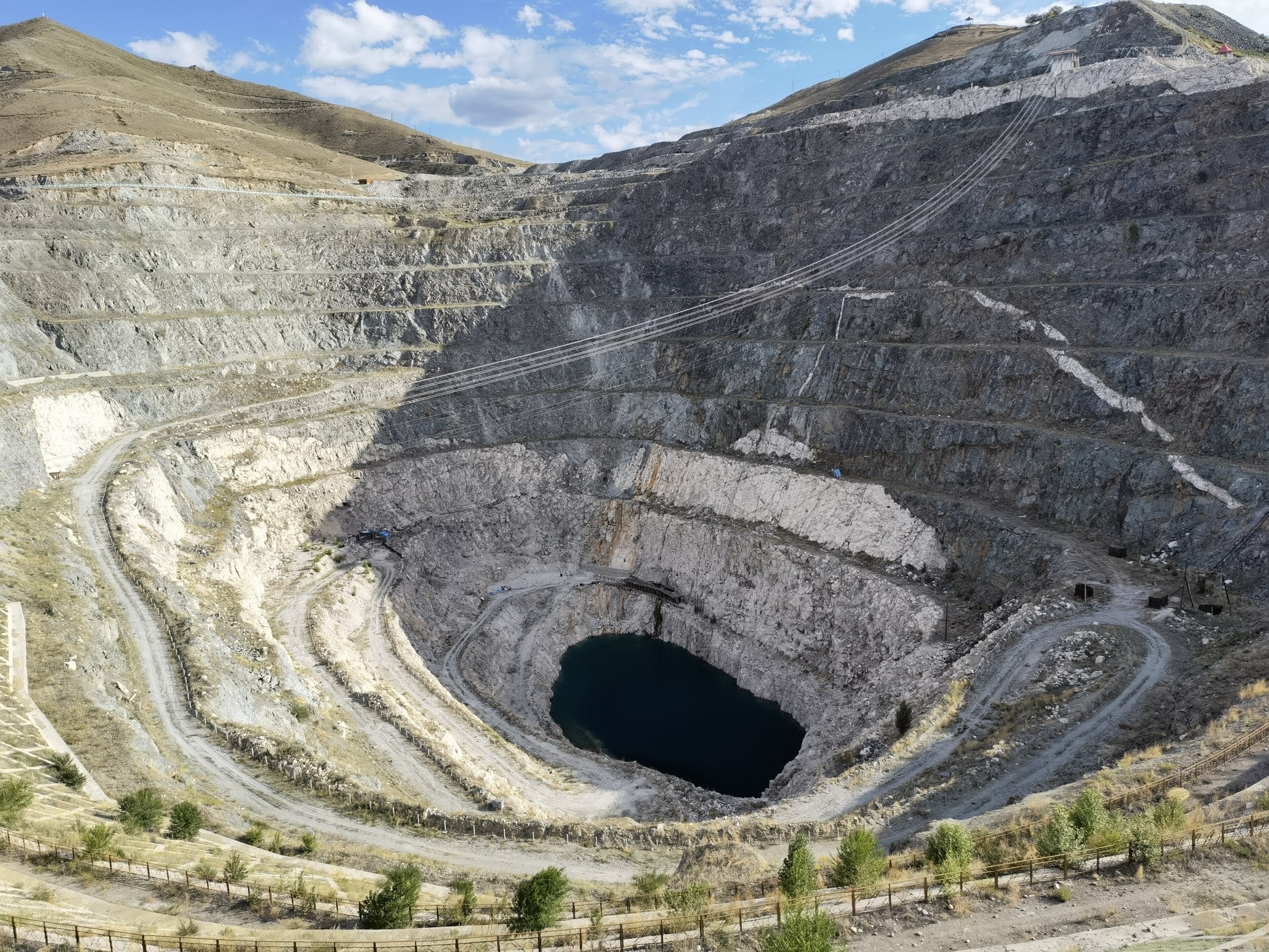
5. No.3 Mine pit and geology museum circuit — 三号矿坑
Snapshot
Itinerary
The walk links the pit-rim viewpoint above the No.3 Mine with the geology museum at the visitor area. The pit itself — the terraced No.3 (Sānhào) rare-metal pegmatite open mine, 247 m long, 238 m wide and 201 m deep — is the most concentrated rare-metal pegmatite ore body in China and the type locality for the wider Altay rare-metal belt. The path climbs gently from the visitor area to the pit-rim viewpoint and a sequence of interpretive panels on the seven rare metals (beryllium, lithium, tantalum, niobium, caesium, rubidium and the rare earths) extracted on site between 1955 and 1999. A short return spur descends to the preserved 1950s headframe and miners’ quarters before reaching the geology museum at the start.
The museum holds an exhibition of tourmaline, beryl, spodumene and tantalite-columbite from the pit, the original Soviet-era mine plans, and a documentary section on the role of the Keketuohai mines in the Sino-Soviet rare-metal trade between 1949 and 1960. The walk is short but the geological context is considerable; budget time for the museum.
Why it is essential
The No.3 Mine is central to Keketuohai’s identity and to its UNESCO global geopark designation for rare-metal mineralogy. It adds the rare-metal mining and Cold War-era industrial heritage story to the canyon, lake and fault walks elsewhere in the geopark.
Hazards and notes
- The pit rim is fenced — stay behind the barriers; the terraced walls are unstable.
- Photography is unrestricted at the pit rim but limited inside the museum gallery.
- Winter ice on the stair sections requires traction.
- The 1950s headframe and miners’ quarters are not open for interior access.
GPX / KML links
| Source | URL | Format | Notes |
|---|---|---|---|
| OpenStreetMap search: No.3 Mine Keketuohai | openstreetmap.org | Map / search | OSM data is ODbL; geometry cross-check only |
| UNESCO — Keketuohai UNESCO Global Geopark | unesco.org | Source page | No.3 pegmatite rare-metal significance |
| TravelChinaGuide — Keketuohai National Park | travelchinaguide.com | Source page | Pit dimensions and mineral list |
Further reading
- UNESCO — Keketuohai UNESCO Global Geopark
- TravelChinaGuide — No.3 Mine within Keketuohai National Park
Further reading
| Source | URL |
|---|---|
| UNESCO — Keketuohai UNESCO Global Geopark | unesco.org |
| Keketuohai UNESCO Global Geopark — official site | keketuohaigeopark.com |
| Keketuohai UNESCO Global Geopark — Irtysh Grand Canyon | keketuohaigeopark.com |
| TravelChinaGuide — Keketuohai National Park | travelchinaguide.com |
| ChinaAdventure — Keketuohai travel guide | chinaadventure.org |
| Wikipedia — 1931 Fuyun earthquake | en.wikipedia.org |
| Into Travel China — Keketuohai UNESCO Geopark | intotravelchina.com |
Missing data and follow-up
- No official GPX or KML downloads were located for any of the five walks. The Keketuohai Geopark Administration publishes attraction descriptions only.
- Hike 1 (Irtysh Grand Canyon): internal shuttle stops, the upper canyon access beyond Jiland Hot Spring and the winter scenic-road regime change year-on-year — confirm at the geopark visitor centre on arrival.
- Hike 2 (Shuimo Valley / White Birch Woods): path loops inside the birch wood are not consistently signed in English; the Entrance–Shuimo Valley shuttle charge is separate from the main geopark ticket.
- Hike 3 (Yileimu Lake): the western-shore walking line and the location of the lakeside shuttle stop change with seasonal water level; no Wikimedia Commons photo of the lake landscape is available.
- Hike 4 (Fuyun earthquake rupture): the interpretive path and museum are a separately ticketed site reached by road from Keketuohai town; some tourism sources cite an incorrect 1933 date for the earthquake — the seismological date is 11 August 1931.
- Hike 5 (No.3 Mine): museum gallery routing and the headframe-area perimeter change with restoration phases; current access should be confirmed on arrival.
- Photo coverage: no licence-compatible Commons photo was located for Shuimo Valley, Yileimu Lake or the Fuyun earthquake-remains area at the time of writing.