Regional overview
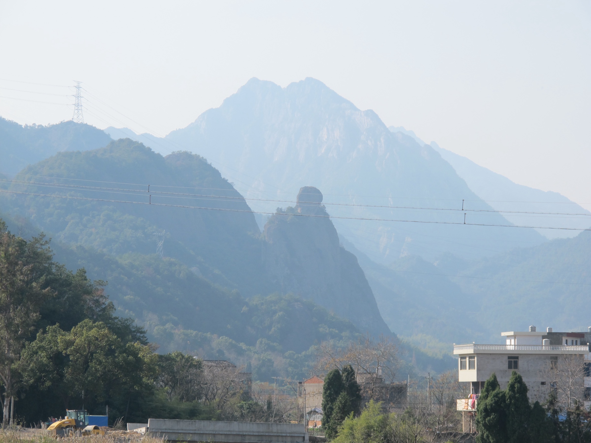
Sanqing Shan (三清山) is a compact granite peak-forest landscape in north-east Jiangxi, gazetted as a UNESCO World Heritage Site in 2008 and a UNESCO Global Geopark. Unlike broader hiking regions, its essential routes are managed scenic-path circuits around cableway stations, high cliff balconies, Taoist temple remains, and named granite formations such as Oriental Goddess (东方女神) and Python Slithers out of Mountain (巨蟒出山). The walking character is stair-and-plank-road rather than open mountain trail — the kind of dense engineered network that defines the eastern-Chinese granite peak-forest aesthetic.
One full public route-page loop is verified here. The other entries are essential scenic circuits whose standalone distance and elevation still need confirmation against an official scenic-area map or a measured GPS track. For neighbouring sub-regions on the same eastern-China watershed, see Tianmu Shan, Zhejiang and Yandang Shan, Zhejiang.
Selection rationale
The five entries cover Sanqing Shan’s essential themes: one full circuit using the managed path network, one Nanqing Garden loop around the iconic granite formations, two adjacent high-level balcony walks (West Coast and Sunshine Coast) that define the cliff-plank-road experience, and one summit-and-temple objective at Yujing Peak. The selection mixes one strenuous full day with three to four short-to-medium scenic sections so the catalogue does not require all five days to be hard.
Summary table
| # | Hike | Route type | Distance | Gain | Max elevation | Difficulty |
|---|---|---|---|---|---|---|
| 1 | Sanqing Mountains Grand Loop | Loop | 18.0 km | 1,884 m | 1,664 m on route | Hard |
| 2 | Nanqing Garden — Oriental Goddess and Giant Python loop | Scenic loop | c. 3–5 km | Unresolved | c. 1,600 m | Easy to moderate |
| 3 | West Coast Cliff Plank Road and Sanqing Palace connector | Traverse / loop section | c. 4–6 km | Unresolved | c. 1,600 m | Moderate |
| 4 | Sunshine Coast high-level balcony | Traverse / loop section | c. 4–6 km | Unresolved | c. 1,600 m | Moderate |
| 5 | Yujing Peak and Sanqing Palace summit route | Summit out-and-back / loop | Unresolved | Unresolved | 1,817 m | Moderate to hard |
1. Sanqing Mountains Grand Loop

Snapshot
Itinerary
The Grand Loop strings together the upper scenic path network: cliff-balcony plank roads, granite formation viewpoints, Taoist temple remains and connectors between cableway stations. Cableway operating hours can define the safe window for completion, especially if the route starts or finishes near an upper station.
Why it is essential
This is the only full circuit verified against a public route page for Sanqing Shan and the best single entry for strong day hikers who want to sample the entire path network. It is much longer and harder than the usual cableway-assisted sightseeing circuits.
Equipment, hazards and notes
Treat as a demanding day on stairs and engineered paths rather than as an undeveloped mountain trail. Trail shoes with grip, sun and rain protection, water, food, and an early start. The plank-road sections expose hikers to drop hazards in fog or ice; the cableway last-descent time can leave a slow party stranded after dark.
GPX / route file
| Source | URL | Format | Reuse status |
|---|---|---|---|
| AllTrails — Sanqing Mountains Loop | alltrails.com | Source map | Reference only |
| Waymarked Trails — hiking map | hiking.waymarkedtrails.org | OSM-based map | Cross-check only |
| OpenStreetMap — search “Sanqing Shan” | openstreetmap.org | OSM | Cross-check only |
External links
- UNESCO World Heritage — Mount Sanqingshan National Park
- UNESCO Global Geopark — Sanqingshan
- Wikipedia — Mount Sanqing
2. Nanqing Garden — Oriental Goddess and Giant Python loop
Snapshot
Itinerary
A scenic-loop traverse of Nanqing Garden takes in Oriental Goddess (东方女神), Python Slithers out of Mountain (巨蟒出山) and the surrounding granite-pillar viewpoints. Exact path choice depends on which upper cableway station the loop is started from.
Why it is essential
Nanqing Garden contains the most recognisable Sanqing Shan granite icons. It is the key short scenic circuit for visitors who want the classic formation views without committing to the full Grand Loop.
Equipment, hazards and notes
Stair shoes with grip, sun and rain protection, water and food. Drops at viewpoints and crowded narrow sections are the main hazards. Do not publish these stats as authoritative until the loop is pinned to a named cableway station and an official scenic-area map; the framing here is essential because the formations are the visual shorthand for Sanqing Shan.
GPX / route file
| Source | URL | Format | Reuse status |
|---|---|---|---|
| OpenStreetMap — search “Nanqing Garden Sanqing Shan” | openstreetmap.org | OSM | Cross-check only |
| UNESCO Geopark — Sanqingshan profile | unesco.org | Page | Feature verification only |
External links
3. West Coast Cliff Plank Road and Sanqing Palace connector

Snapshot
Itinerary
The West Coast path is a high-level balcony traverse on engineered plank road along the granite cliffs, with links toward the Taoist Sanqing Palace area. A standalone version is a quick out-and-back; a longer version connects to Sanqing Palace via the upper path network.
Why it is essential
The West Coast is one of Sanqing Shan’s signature cliff-balcony walks and represents the suspended-path experience that defines the site’s heritage description.
Equipment, hazards and notes
Footwear with grip, sun and rain protection, water and food. The plank road is exposed: weather, ice, fog and crowded narrow sections are the main hazards. Decide before the day whether this is standalone from a cableway station, half of the Grand Loop, or a connector to Sanqing Palace — choice changes distance and return logistics.
GPX / route file
| Source | URL | Format | Reuse status |
|---|---|---|---|
| OpenStreetMap — search “West Coast Sanqing Shan” | openstreetmap.org | OSM | Cross-check only |
| UNESCO World Heritage listing — Sanqingshan | whc.unesco.org | Page | Site / path-network context only |
External links
4. Sunshine Coast high-level balcony
Snapshot
Itinerary
Sunshine Coast is the east-side high-level balcony, paired editorially with West Coast for users who want a second engineered cliff route. It can be walked from its dedicated cableway station, or combined with West Coast for a longer scenic circuit.
Why it is essential
It gives a second cliff-balcony route across Sanqing Shan’s granite scenery and is the natural companion to West Coast when building a full-day path from shorter managed scenic sections.
Equipment, hazards and notes
Same engineered-path kit as West Coast: shoes with grip, sun and rain protection, water and food. Pin a final official-map trace before publishing exact stats; in practice this route may work best as a combined West + Sunshine Coast full-day circuit rather than as a separate short hike.
GPX / route file
| Source | URL | Format | Reuse status |
|---|---|---|---|
| OpenStreetMap — search “Sunshine Coast Sanqing Shan” | openstreetmap.org | OSM | Cross-check only |
| UNESCO World Heritage listing — Sanqingshan | whc.unesco.org | Page | Site / path-network context only |
External links
5. Yujing Peak and Sanqing Palace summit route
Snapshot
Itinerary
Yujing Peak is Sanqing Shan’s highest summit objective; Sanqing Palace anchors the mountain’s Taoist cultural landscape. A summit-and-palace route is the most logical combined natural-and-cultural day, but the exact path requires confirmation that the Yujing summit section is currently open to ordinary visitors and that the connector to Sanqing Palace is walkable in a single day.
Why it is essential
This is the only entry that combines the high point with the principal Taoist cultural site, and it is essential for a catalogue that includes both natural and cultural highlights.
Equipment, hazards and notes
Engineered-path kit plus extra time margin for the summit section. The biggest open questions are access status (ordinary visitors vs guided / restricted), seasonal closures and day-trip feasibility — confirm at the scenic-area gate before committing.
GPX / route file
| Source | URL | Format | Reuse status |
|---|---|---|---|
| OpenStreetMap — search “Yujing Peak Sanqing Shan” | openstreetmap.org | OSM | Cross-check only |
| UNESCO Geopark — Sanqingshan profile | unesco.org | Page | Cultural / geological context only |
| UNESCO World Heritage listing — Sanqingshan | whc.unesco.org | Page | Landscape and elevation context only |
External links
- UNESCO World Heritage — Mount Sanqingshan National Park
- UNESCO Global Geopark — Sanqingshan
- Wikipedia — Mount Sanqing