Regional overview
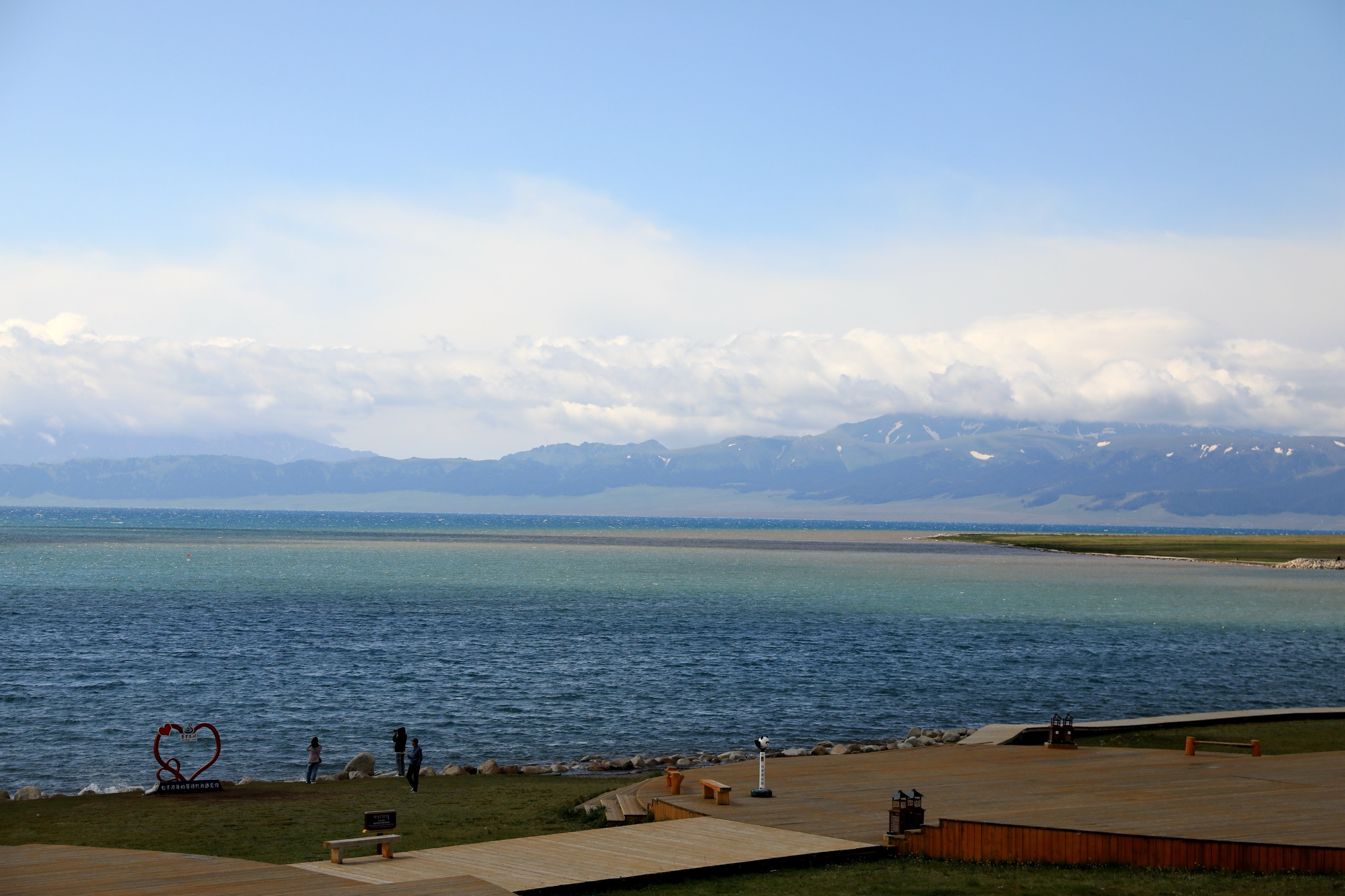
Sayram Lake (赛里木湖, Sàilǐmù Hú) is the largest and highest alpine lake in Xinjiang, sitting at 2,072 m in a closed basin between the northern flank of the Borohoro range and the southern spurs of the Dzungarian Alatau. The lake covers about 458 km² and has a shoreline of roughly 90 km, framed by short-grass steppe, scattered Mongolian and Kazakh herders’ camps, and snow-capped ridges that hold patches of glacier into late summer. Bortala Mongol Autonomous Prefecture surrounds the lake; the prefectural capital is Bole (博乐), and the border town of Alashankou is the railhead for the cross-border line to Kazakhstan.
The Sayram Lake Scenic Area is rated 5A by the China National Tourism Administration and runs a ticketed entry system with mandatory shuttle buses between named viewpoints. The standard tourist circuit is the 90 km shoreline loop road, broken into clockwise stages: East Gate, Moon Bay (月亮湾), Lakeside Beach (湖滨浴场), Dianjiangtai (点将台), West Sea Grassland (西海大草原), Songshutou (松树头) and the South Gate. The lake is closed to private cars; visitors transfer between viewpoints by scenic-area bus, bicycle, or — within shorter sectors — on foot. The hikes described here use those named viewpoints as trailheads. Adjacent to the lake on its south-east approach is the Guozigou Valley (果子沟, “Fruit Valley”), a deep V-shaped pass on the G312 corridor between Sayram and Yining, spanned by the 700 m-tall Guozigou Bridge.
The main hiking season is late May to early September. Wildflowers — Pulsatilla, edelweiss, gentian, Iris and the regionally famous golden poppies — peak in mid-June and mid-July, and the steppe stays cool to 5–10 °C even in midsummer. Outside summer the lake freezes from December to March and is well known for blue-ice photography in February, but walking conditions in winter are severe (wind, sub-zero overnight temperatures, no shelter). Sayram sits in a high-altitude steppe basin; sun exposure is intense and afternoon thunder showers are common.
Bortala Prefecture is a border-zone area; foreign visitors typically need their passports for scenic-area entry, and access to the Alashankou and Wenquan frontier strip beyond the lake requires permits checked at military or border-police posts. Internet and mobile reception are intermittent on the shoreline road.
Selection rationale
The five hikes give the most representative day-walks within and adjacent to the Sayram Lake Scenic Area. The Songshutou viewpoint walk is the iconic Sayram south-bank photographic vantage. The West Sea Grassland walk is the headline wildflower route. The Moon Bay to Dianjiangtai segment covers the east shore with its varied bays. The Guozigou Valley viewpoint walk adds the adjoining bridge and pass landscape that most travellers see on the approach. The north-shore ridge walk gives a higher-elevation panoramic alternative to the lake-level routes.
Summary table
| # | Hike | Country | Route type | Distance | Gain | Max elevation | Difficulty |
|---|---|---|---|---|---|---|---|
| 1 | Songshutou south-shore viewpoint walk | China | Out-and-back | 4-6 km | ~150-250 m | ~2,250 m | Easy-moderate |
| 2 | West Sea Grassland (Xihai) wildflower walk | China | Loop / linear | 6-10 km | ~80-150 m | ~2,150 m | Easy |
| 3 | Moon Bay to Dianjiangtai shoreline segment | China | Point-to-point | 8-12 km | ~100-150 m | ~2,100 m | Easy |
| 4 | Guozigou Valley viewpoint walk | China | Out-and-back | 5-8 km | ~250-400 m | ~1,900 m | Moderate |
| 5 | North-shore ridge walk above Sayram | China | Out-and-back | 6-9 km | ~400-600 m | ~2,500 m | Moderate-strenuous |
1. Songshutou south-shore viewpoint walk
Snapshot
Itinerary
From the Songshutou shuttle stop on the south shore, a short trail climbs the gentle knoll behind the bus apron through pine-clump grassland — Songshutou itself translates as “pine grove head” — and onto a broad open shelf overlooking the lake. The path follows the contour east along the shelf, with the full sweep of Sayram below and the snow-capped Dzungarian Alatau on the opposite shore. From the easternmost viewpoint the route returns by the outbound path. The shelf is widely cited as the best photographic vantage point on the lake.
Why it is essential
Songshutou is the canonical Sayram viewpoint and the headline photographic location for the scenic area. The position on the south bank gives the long lake-and-mountain panorama used in almost all published images of the region, and the short ascent makes it the most accessible high-vantage walk anywhere on the shoreline.
Equipment
- Standard hiking shoes
- Windproof layer (the south shore is exposed and breezy)
- Sun protection (high-altitude steppe glare)
- 1-2 litres of water
- Hat and gloves for early-morning starts
Hazards and notes
- Scenic-area ticket required at the gate; transfer to the Songshutou stop is by the scenic-area shuttle bus
- The shelf has no shade; afternoon thunder showers are common
- Cattle and grazing horses cross the path; close gates and avoid disturbing herds
- Foreign visitors are usually asked for passports at the entry gate
GPX / KML links
No open route file located. Songshutou shuttle stop approximately 44.530°N, 81.250°E; verify locally.
External links
2. West Sea Grassland (Xihai) wildflower walk
Snapshot
Itinerary
The West Sea Grassland is the open flowering meadow on the western shoreline between the lake and the inner ring road. From the Xihai shuttle stop, a network of unmade tracks and a parallel cycling/walking corridor head south along the shore in the direction of Songshutou, crossing low rises of short-grass steppe scattered with seasonal pools, ger camps, and grazing horses. Several short side spurs drop to the water for shoreline panoramas; the inland edges of the route pass into denser flower meadow above the road. The route can be walked as a there-and-back or extended as a linear segment to the next shuttle stop for the return.
Why it is essential
This is the headline Sayram wildflower walk. From mid-June to mid-July the western steppe is the most densely flowered section of the shoreline — golden poppies (Trollius altaicus), Iris, and a wide range of alpine herbs — and the route gives sustained exposure to the meadow at walking pace rather than from the bus.
Equipment
- Standard hiking shoes
- Sun protection
- 1-2 litres of water
- Light insect repellent in midsummer
- Bear-aware behaviour is not required at Sayram, but herder dogs are common; give camps a wide berth
Hazards and notes
- The Xihai meadow is grazed by Mongolian and Kazakh pastoralists; cattle, sheep and horses share the path
- Off-track walking on flowering meadow is discouraged for ecological reasons; stay on tracks where possible
- Scenic-area rules restrict camping outside designated zones
- Sudden afternoon storms and hail are not uncommon
GPX / KML links
No open route file located. West Sea Grassland centroid approximately 44.550°N, 81.140°E; verify locally.
External links
3. Moon Bay to Dianjiangtai shoreline segment
Snapshot
Itinerary
This is a representative linear segment of the inner ring corridor on the east side of the lake. From the Moon Bay stop the route follows the cycling and walking path north past Lakeside Beach (湖滨浴场), with intermittent sand and shingle bays and views west across the open lake. The corridor passes between the inner ring road and the shoreline, separated from vehicle traffic by the scenic-area’s restricted-access bus system. The route ends at Dianjiangtai, a low promontory traditionally named for a Mongolian or Manchu reviewing stand.
Why it is essential
The east-shore segment is the most varied bay-and-headland stretch of the shoreline and pairs well with the south-shore Songshutou panorama and the west-shore wildflower walk to give a full sense of Sayram on foot in two or three days.
Equipment
- Standard hiking shoes
- Sun protection
- Windproof and warm layers
- 2 litres of water
- Snacks; no permanent food kiosks between the two shuttle stops
Hazards and notes
- Bays can be windy and exposed; lake-effect rain bands move quickly
- The cycling corridor is shared with bicycle hire from Moon Bay; walkers should keep to the pedestrian lane
- Scenic-area shuttle service ends in the late afternoon; check the published timetable at the East Gate before starting
GPX / KML links
No open route file located. Moon Bay shuttle stop approximately 44.580°N, 81.250°E; Dianjiangtai approximately 44.600°N, 81.220°E; verify locally.
External links
4. Guozigou Valley viewpoint walk
Snapshot
Itinerary
Guozigou (果子沟, “Fruit Valley”) is a deep V-shaped pass on the historic G312 corridor between Sayram and Yining, traversed by the modern Guozigou Bridge — a curved cable-stayed span that ranks among the highest road bridges in China. From a side track off the G312 north of the bridge, an informal foot route climbs the steep valley flank through wild apple, walnut and apricot forest to a ridge viewpoint overlooking the bridge and the Ili valley. Return reverses the ascent. The wider valley is a recognised wild-apple gene reserve, and during the apple blossom in early May the slopes turn pink and white.
Why it is essential
Guozigou is the canonical landscape view on the approach to Sayram from the south, and the bridge has become one of the most-photographed engineering structures in inland China. Walking above the road gives a perspective that the standard tourist drive-through does not, and crosses one of the world’s largest concentrations of wild Malus sieversii.
Equipment
- Sturdy boots
- Trekking poles for the steep flank
- Sun protection
- 2 litres of water
- Insect repellent in summer (the wild apple thickets are dense)
Hazards and notes
- The valley is steep and forested; informal paths can be hard to follow and slippery after rain
- The G312 below carries fast traffic; do not walk along the road shoulder
- Pastoral grazing in the upper valley; herder dogs may approach
- No formal park infrastructure or signage — this is a candidate route that needs local confirmation before publication
GPX / KML links
No open route file located. Guozigou Bridge approximately 44.380°N, 81.000°E; verify locally.
External links
5. North-shore ridge walk above Sayram
Snapshot
Itinerary
The Dzungarian Alatau spurs that frame Sayram’s north shore rise steeply to ridges between 2,400 and 2,800 m. From a pull-off on the inner ring road, an informal pastoralist track climbs the open grass slope through a series of moraine benches to a knoll on the lower ridge. The high point gives a full bird’s-eye view of the lake set in the bowl, and on clear days the higher snowfields of the Alatau visible to the north. Return reverses the ascent.
Why it is essential
The north-shore ridge is the only widely-documented route giving a high-elevation overhead view of the lake, complementing the lake-level Songshutou perspective. The walk also crosses the transition from grazed pasture to the genuine alpine zone of the Dzungarian Alatau, with snow patches lingering on north-facing aspects into late summer.
Equipment
- Sturdy boots
- Warm and windproof layer for the ridge
- Sun protection
- 2-3 litres of water
- Trekking poles for the descent
Hazards and notes
- No waymarking or formal trail; route-finding requires good visibility
- Cloud can drop quickly on the ridge; turn back if the lake disappears below
- Pastoralist camps and herder dogs are common on the lower slopes
- Some north-shore sectors lie close to military/border-zone strips; check current restrictions with the scenic-area office before starting
GPX / KML links
No open route file located. North-shore inner ring road centroid approximately 44.610°N, 81.180°E; verify locally.
External links
External links
| Resource | Link |
|---|---|
| Wikipedia — Sayram Lake | en.wikipedia.org |
| Wikipedia — Bortala Mongol Autonomous Prefecture | en.wikipedia.org |
| Wikipedia — Dzungarian Alatau | en.wikipedia.org |
| Wikipedia — Guozigou Bridge | en.wikipedia.org |
| Wikimedia Commons — Category:Sayram Lake | commons.wikimedia.org |
| intotravelchina — Guozigou (Fruit Valley) | intotravelchina.com |
| China Discovery — Sayram Lake | chinadiscovery.com |
| Xinjiang Travel — Sayram Lake | xinjiangtravel.org |