Regional overview
The Chongqing-Sichuan border sector of the Daba Mountains is a rugged, humid mountain belt of karst gorges, forested ridges, high meadows, cliff plank roads, deep valleys and scattered Tujia / Bashu cultural landscapes. The strongest public walking areas found in this pass are Bashan Grand Canyon in Xuanhan, Batai Mountain in Wanyuan, Hongchiba in Wuxi, and the Chengkou highland / Kanggu / Huang’anba Daba Mountain sector.
The walking character is mostly managed scenic-area hiking: boardwalks, stone steps, cliff paths, shuttle-assisted gorge walks, alpine pasture roads, and short forest routes. Legal independent backcountry access is unclear in many nature-reserve zones, so publication-ready routes should stay on open scenic-area paths and mapped public tracks.
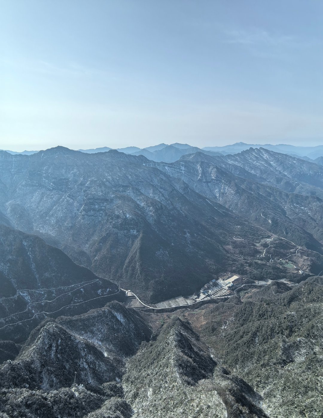
The main season is April-November. Summer is hot and stormy at low elevations but cooler on high ridges; autumn is important for red leaves and cloud seas; winter can bring snow, rime, icy roads and limited access.
Selection rationale
The five hikes represent the border region’s main walking types: a karst grand-canyon plank walk, a high Batai Mountain cloud-sea route, an alpine meadow day at Hongchiba, a forest-canyon route at Kanggu, and the Huang’anba high-pasture landscape of northern Chongqing. Exact GPX data is thin, so several entries remain candidate / partially verified until current scenic-area maps or field tracks are obtained.
Summary table
| # | Hike | Country | Route type | Distance | Gain | Max elevation | Difficulty |
|---|---|---|---|---|---|---|---|
| 1 | Bashan Grand Canyon Taoxi Valley and Luopanding walk | China | Shuttle-assisted gorge and cliff walk | Approx. 5-8 km combined; Taoxi Valley plank trail around 3 km | Moderate | ||
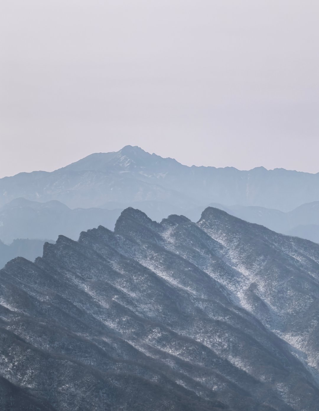
| 2 | Batai Mountain cloud-sea summit and cliff plank walk | China | Lift / shuttle-assisted high scenic walk | Approx. 3-6 km walking; exact total unresolved | Limited if lift/shuttle used | Main peak 2,348 m | Moderate; exposed sections |
| 3 | Hongchiba Tianzicheng and Yinchangping alpine meadow walk | China | High meadow loop / out-and-back | Approx. 5-10 km; exact route unresolved | Low-moderate | Scenic area approx. 1,800-2,600 m | Easy-moderate |
| 4 | Chengkou Kanggu forest canyon walk | China | Canyon / forest out-and-back or loop | Approx. 4-8 km; exact route unresolved | Around 1,400 m scenic-area level | Moderate | |
| 5 | Huang’anba high pasture and Jiuchong Mountain forest walk | China | High pasture / forest road walk | Approx. 5-12 km; exact route unresolved | Low-moderate | Average elevation around 2,200 m | Easy-moderate |
1. Bashan Grand Canyon Taoxi Valley and Luopanding Walk

Snapshot
Itinerary
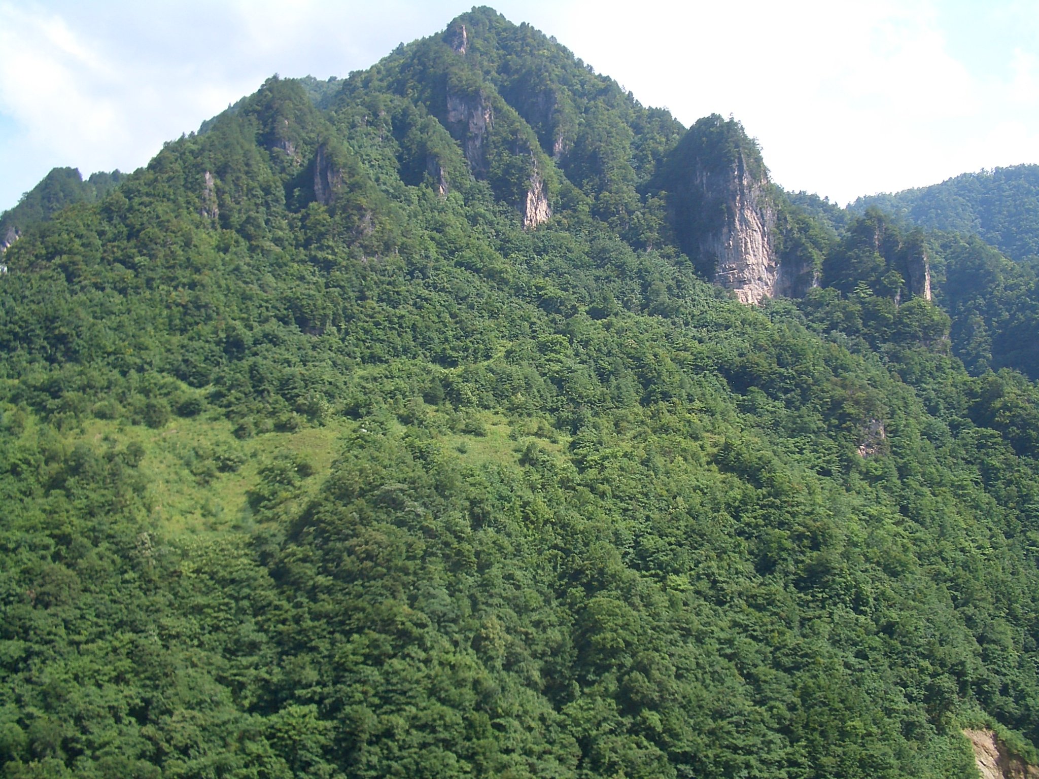
Use the managed Bashan Grand Canyon transport system to walk the Taoxi Valley plank trail and, if open, continue to Luopanding / cliff-view sections such as Dahongyan or glass-plank viewpoints. Public tourism sources describe Bashan Grand Canyon as a Daba Mountains karst canyon landscape with multiple valleys, caves, waterfalls, cliffs and Tujia cultural sites.
The only route length found in current public source text was the Taoxi Valley plank trail at about 3 km. The full combined walking day depends on which scenic sections are open and how shuttle transfers are arranged.
Why it is essential
Bashan Grand Canyon is the most important gorge walk on the Sichuan side of this Daba border region, combining karst, waterfalls, cliff paths and minority-culture landscape in one managed day.
Equipment
Sturdy shoes with wet-rock grip, rain protection, water, sun protection, and warm layer in shoulder seasons. Carry enough water and snacks in case shuttle waits are long.
Hazards and notes
Do not enter gorges in heavy rain or flood warnings. Cliff paths, glass walkways, elevators and plank roads may close in storms, ice or high wind. Crowding can be significant on holidays.
GPX / KML links
| Source | URL | Format / access | Reuse status |
|---|---|---|---|
| OpenStreetMap search: Bashan Grand Canyon | openstreetmap.org | Map/search | OSM data is ODbL; geometry cross-check only |
| BH2255 Bashan Grand Canyon guide | bh2255.com | Source page | No route-file licence found; scenic-feature verification only |
External links
2. Batai Mountain Cloud-Sea Summit and Cliff Plank Walk
Snapshot
Itinerary
The day uses Batai Mountain Scenic Area’s internal access to reach the high limestone ridge, cloud-sea viewpoints, glass or cliff-plank sections, and summit sightseeing areas. The official scenic-area source describes Batai Mountain as northeast Sichuan, 110 square kilometres, with a 2,348 m main peak and stepped landform. Trip.com also identifies glass plank road, high-altitude activities and the need to use internal shuttle transport across a relatively long scenic route.
The route should be treated as a managed high scenic walk until a current official walking map or GPX is available.
Why it is essential
Batai Mountain is the strongest high-ridge viewpoint on the Sichuan side of the border region, representing Daba cloud seas, steep karst relief and developed cliff-path walking.
Equipment
Sturdy shoes, windproof layer, rain shell, water, sun protection, and warm clothing outside midsummer. In winter, check whether snow chains, traction or closure notices apply.
Hazards and notes
Glass walkways, cliff paths, exposed viewpoints and winter ice are the main hazards. Do not count on doing all sections on foot if the scenic area requires shuttle or lift access.
GPX / KML links
| Source | URL | Format / access | Reuse status |
|---|---|---|---|
| OpenStreetMap search: Batai Mountain Wanyuan | openstreetmap.org | Map/search | OSM data is ODbL; geometry cross-check only |
| Batai Mountain scenic-area site | bts517.com | Source page | No route-file licence found; scenic-area context only |
External links
3. Hongchiba Tianzicheng and Yinchangping Alpine Meadow Walk
Snapshot
Itinerary
Plan a high-meadow walking day around the open public parts of Hongchiba National Forest Park, prioritising Tianzicheng Grassland, Yinchangping, flower-sea or forest-edge paths depending on current access. Public travel sources describe Hongchiba as an alpine meadow and forest-park landscape in Wuxi County, deep in the Daba Mountains, with high elevations and broad grassland scenery.
No reliable walking-only route file was found. The entry should not be treated as a fixed GPX route until a current park map is obtained.
Why it is essential
Hongchiba gives this Daba border entry its high-pasture and open-meadow landscape, contrasting with the gorges of Bashan Grand Canyon and Kanggu.
Equipment
Comfortable hiking shoes, wind layer, rain protection, sun protection, water, and warm clothing in shoulder seasons or for early morning cloud-sea viewing.
Hazards and notes
Fog, thunderstorms, cold wind, icy winter roads and limited services are the main issues. Stay on open paths and roads to protect meadow vegetation.
GPX / KML links
| Source | URL | Format / access | Reuse status |
|---|---|---|---|
| OpenStreetMap search: Hongchiba Wuxi | openstreetmap.org | Map/search | OSM data is ODbL; geometry cross-check only |
| Trip.com Hongchiba National Forest Park page | trip.com | Source page | No route-file licence found; scenic-area context only |
External links
- Trip.com — Hongchiba National Forest Park
- Go Western China — Wuxi guide and Hongchiba overview
- CQNEWS English — grasslands hidden in Chongqing
4. Chengkou Kanggu Forest Canyon Walk
Snapshot
Itinerary
Use the open Kanggu Scenic Area paths to walk through the forested canyon, stream and cliff landscape of eastern Chengkou. iChongqing describes Kanggu as a national 4A scenic spot combining canyons, forests, peaks, cliffs, streams and unusual rock formations, within the Daba Mountain hinterlands.
The exact walking route, distance and elevation were not verified from an official route map in this pass. This should remain a candidate route until the current scenic-area map is sourced.
Why it is essential
Kanggu is the most direct managed canyon-forest walk for Chengkou, the Chongqing county most strongly identified with the Daba Mountain hinterland and border ecology.
Equipment
Sturdy shoes, rain shell, water, insect protection in warm wet periods, and an offline map. Carry extra food if relying on local transport.
Hazards and notes
Storms, slippery boardwalks, falling rock in narrow canyon zones, and limited transport are the main hazards. Do not enter nature-reserve or undeveloped zones beyond public paths.
GPX / KML links
| Source | URL | Format / access | Reuse status |
|---|---|---|---|
| OpenStreetMap search: Kanggu Chengkou | openstreetmap.org | Map/search | OSM data is ODbL; geometry cross-check only |
| iChongqing Kang Gu attraction page | ichongqing.info | Source page | No route-file licence found; scenic-area context only |
External links
- iChongqing — Chengkou Kang Gu attraction page
- iChongqing — Chengkou Daba Mountain hinterlands overview
5. Huang’anba High Pasture and Jiuchong Mountain Forest Walk
Snapshot
Itinerary
Plan a legal public-path or road-walk day across the Huang’anba high pasture and forest-edge scenery, with Jiuchong Mountain / Daba Mountain viewpoints included only where open and mapped. iChongqing describes Huang’anba Ecological Base as about 200 square kilometres, with mountain grasslands, forests and canyons, and an average elevation around 2,200 m. CQNEWS identifies Huang’anba as a Daba Mountain alpine meadow about 70 km from Chengkou.
No fixed public GPX was found. The route needs a current scenic-area map or locally recorded track before being finalised.
Why it is essential
Huang’anba is one of northern Chongqing’s defining Daba highland landscapes: open pasture, cool summer climate, forest edge and broad ridge country rather than gorge walking.
Equipment
Windproof layer, rain shell, sun protection, water, warm clothing for high-elevation weather, and offline navigation if walking beyond the central pasture area.
Hazards and notes
Fog, lightning, cold wind, icy winter roads and limited services are the main hazards. Avoid entering closed ecological protection zones or unsigned grazing/forest tracks.
GPX / KML links
| Source | URL | Format / access | Reuse status |
|---|---|---|---|
| OpenStreetMap search: Huang’anba Chengkou | openstreetmap.org | Map/search | OSM data is ODbL; geometry cross-check only |
| iChongqing Chengkou highland overview | ichongqing.info | Source page | No route-file licence found; scenic-area context only |
External links
- iChongqing — Chengkou Daba Mountain hinterlands and Huang’anba overview
- CQNEWS English — grasslands hidden in Chongqing
- Trip.com — Daba Mountain / Huang’anba travel notes
External links
| Source | URL |
|---|---|
| BH2255 — Bashan Grand Canyon travel guide | bh2255.com |
| Trip.com — Bashan Grand Canyon | trip.com |
| Batai Mountain scenic-area site | bts517.com |
| Trip.com — Batai Mountain | trip.com |
| Trip.com — Hongchiba National Forest Park | trip.com |
| Go Western China — Wuxi and Hongchiba | gowesternchina.com |
| iChongqing — Chengkou Kang Gu | ichongqing.info |
| iChongqing — Chengkou Daba Mountain hinterlands | ichongqing.info |
| CQNEWS English — Chongqing grasslands including Huang’anba and Hongchiba | english.cqnews.net |
| Trip.com — Daba Mountain / Huang’anba travel notes | in.trip.com |