Regional overview
The Uyuni-Lípez volcanic Andes are a vast, high, dry and vehicle-dependent walking region built around the Salar de Uyuni, Tunupa, the Sud Lípez volcanoes, and the Reserva Nacional de Fauna Andina Eduardo Avaroa. Many classic “hikes” here begin from 4WD roadheads during multi-day salt-flat circuits rather than from towns with marked trail networks.
Walking conditions are shaped by altitude from about 3,650 m to nearly 6,000 m, intense sun, cold wind, scarce water, fragile geothermal ground, salt-flat access, and long rescue distances. The official Eduardo Avaroa tourism regulation confirms that visitor use is limited to established public-use spaces and authorised routes, but it does not provide neat day-hike GPX data for every attraction. Third-party route databases therefore supply most distance/elevation statistics.
Selection rationale
The set covers the region’s core non-technical walking experiences: a short salar-island circuit at Incahuasi, the Tunupa volcano viewpoint/summit-side route, the very high Uturuncu roadhead climb, the serious Licancabur volcano route inside Eduardo Avaroa, and the Sol de Mañana geothermal site walk. The final entry has intentionally unresolved distance because safe walking there is controlled more by site boundaries than by a named trail.
Summary table
| # | Hike | Country | Route type | Distance | Gain | Max elevation | Difficulty |
|---|---|---|---|---|---|---|---|
| 1 | Incahuasi Island Circuit | Bolivia | Loop | 1.1 km | 53 m | 3,714 m | Moderate |
| 2 | Tunupa Volcano loop from the salar side | Bolivia | Loop | 5.0 km | 607 m | 5,204 m | Hard |
| 3 | Uturuncu Volcano high roadhead climb | Bolivia | Out-and-back | 1.8 km | 276 m | 5,998 m | Hard, extreme altitude |
| 4 | Licancabur Volcano from the Bolivian side | Bolivia | Out-and-back | 7.6 km | 1,280 m | 5,902 m | Hard |
| 5 | Sol de Mañana geothermal field walk | Bolivia | Managed site walk | ca. 4,800-5,000 m unresolved | Easy-moderate if kept short; hazardous ground |
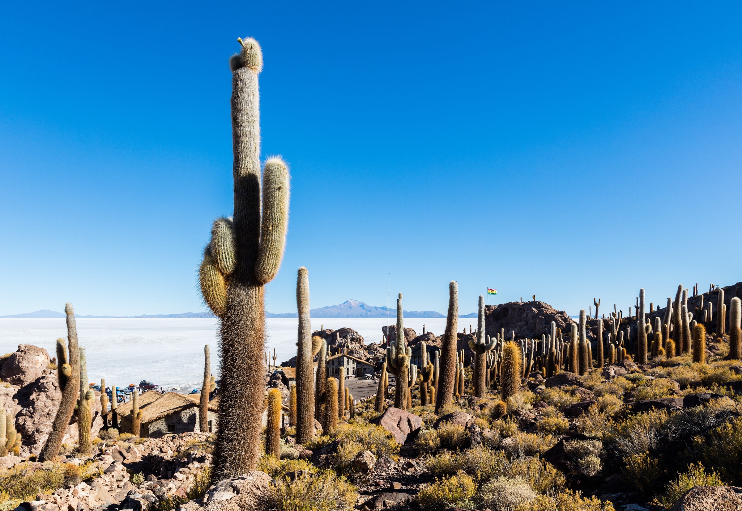
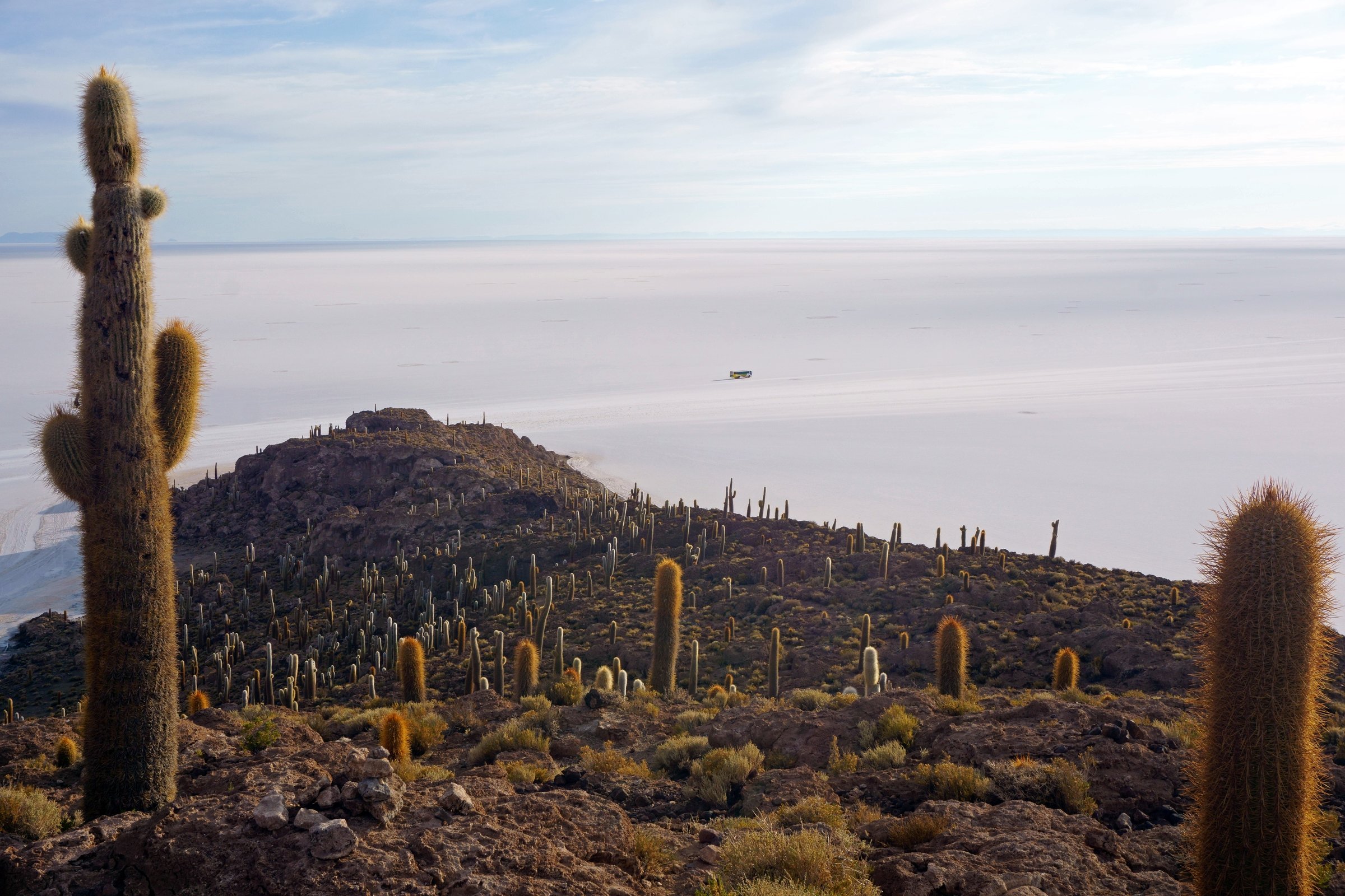
1. Incahuasi Island Circuit
Snapshot
Itinerary
The trail loops through the cactus-covered coral-rock island in the middle of the Salar de Uyuni. It climbs to viewpoints over the white salt flat and passes old reef-like rock formations and giant cacti.
Why it is essential
Incahuasi is the most established short walk on the Salar de Uyuni and turns a scenic vehicle stop into an actual hike with height, texture, and broad views.
Equipment
- Walking shoes
- Sun hat, sunglasses, sunscreen
- Wind layer
- Water
- Cash for local entry if charged
- Avoid sandals on the rock and cactus-lined paths
Hazards and notes
- Salt-flat access can change with flooding, storms, and tour-operator routing.
- Stay on the island trail to protect cactus and fragile rock surfaces.
GPX / KML links
| Source | URL | Format / access | Reuse status |
|---|---|---|---|
| AllTrails: Incahuasi Island Circuit | alltrails.com | Source map / route statistics; AllTrails terms apply | Stats verified; direct GPX reuse unresolved |
External links
2. Tunupa Volcano loop from the salar side
Snapshot
Itinerary
The source route climbs steeply from the Tunupa side above the salt flat, with views over Salar de Uyuni and nearby archaeological/cave sites around Coquesa. It is a shorter loop than longer crater/summit variants but still reaches very high altitude.
Why it is essential
Tunupa is the volcano that dominates the northern edge of the Salar de Uyuni. This route gives the most direct day-hike expression of that landscape without requiring a long expedition.
Equipment
- Mountain day equipment
- Warm layers
- Wind shell
- Sun protection
- Water and food
- Offline navigation
- Trekking poles on steep volcanic ground
Hazards and notes
- Altitude, steep loose ground, strong wind, and access across the salar are the main concerns.
- Exact local trailhead, cave-site access rules, and community permissions require local confirmation.
GPX / KML links
| Source | URL | Format / access | Reuse status |
|---|---|---|---|
| AllTrails: Tunupa Volcano | alltrails.com | Source map / route statistics; AllTrails terms apply | Stats verified; direct GPX reuse unresolved |
| AllTrails: Tunupa Volcano Crater Trail | alltrails.com | Longer source route variant; AllTrails terms apply | Secondary route context only |
External links
3. Uturuncu Volcano high roadhead climb
Snapshot
Itinerary
The source route starts extremely high on the volcano road and climbs the final volcanic slope to the summit area. A longer AllTrails slopes variant exists at 6.3 km and 322 m gain to a lower maximum elevation, which may better reflect a lower roadhead day.
Why it is essential
Uturuncu is one of the highest walkable volcano objectives in the region because of its road access. The short distance is misleading: the route is defined by near-6,000 m altitude.
Equipment
- Full high-altitude kit: warm layers, shell, gloves, hat
- Sunglasses and sunscreen
- Water and food
- Navigation
- Emergency insulation
- Conservative acclimatisation plan
Hazards and notes
- Altitude illness is the dominant risk.
- Vehicle access, snow, wind, remoteness, and roadhead height determine the true difficulty.
- Do not attempt without acclimatisation and a reliable retreat plan.
GPX / KML links
| Source | URL | Format / access | Reuse status |
|---|---|---|---|
| AllTrails: Uturuncu Volcano | alltrails.com | Source map / route statistics; AllTrails terms apply | Stats verified; direct GPX reuse unresolved |
| AllTrails: Uturuncu Volcano Slopes | alltrails.com | Longer/lower variant source; AllTrails terms apply | Secondary route context |
External links
4. Licancabur Volcano from the Bolivian side
Snapshot
Itinerary
The route ascends the Bolivian side of Licancabur inside Eduardo Avaroa reserve terrain. The AllTrails source describes Inca ruins near the start and the crater-lagoon reward near the summit.
Why it is essential
Licancabur is the most iconic volcano on the Laguna Verde horizon and one of the strongest high-volcano day objectives in South-western Bolivia for experienced, acclimatised hikers.
Equipment
- Full high-altitude mountain kit: boots, warm layers, shell, gloves, hat
- Sunglasses and sunscreen
- Water and food
- GPS/offline map
- Emergency insulation
- Local guide, permit/park-entry arrangements, and current route condition checks
Hazards and notes
- This is a serious near-6,000 m ascent with large height gain, remote access, and weather exposure.
- The Eduardo Avaroa regulation requires visitors to use established public-use spaces and comply with protected-area rules.
GPX / KML links
| Source | URL | Format / access | Reuse status |
|---|---|---|---|
| AllTrails: Licancabur Volcano | alltrails.com | Source map / route statistics; AllTrails terms apply | Stats verified; direct GPX reuse unresolved |
| SERNAP ROTE Eduardo Avaroa | sernap.gob.bo (PDF) | Official protected-area tourism regulation; SERNAP PDF | Access/rules context, not GPX |
External links
5. Sol de Mañana geothermal field walk
Snapshot
Itinerary
The walk is a controlled geothermal-site visit rather than a long trail. The safe route is whatever is currently authorised around the fumaroles, steam vents, and mud pools at Sol de Mañana inside Eduardo Avaroa reserve.
Why it is essential
Sol de Mañana is the region’s clearest geothermal walking stop and a key volcanic landscape of the standard South Lípez circuit. It belongs in a day-hike catalogue as a short, rule-bound site walk, not as an open wandering route.
Equipment
- Warm layers
- Wind shell
- Sun protection
- Sturdy shoes (do not use sandals near geothermal ground)
- Water
- Camera protection from steam/dust
Hazards and notes
- This is hazardous geothermal terrain.
- Stay on signed or guide-designated paths, keep away from crust edges, fumaroles, boiling mud, and steam vents, and follow reserve instructions.
- The official regulation requires visitors to remain within public-use areas and established paths.
GPX / KML links
| Source | URL | Format / access | Reuse status |
|---|---|---|---|
| SERNAP ROTE Eduardo Avaroa | sernap.gob.bo (PDF) | Official protected-area tourism regulation; SERNAP PDF | Official access/rules context, not GPX |
| Sol de Mañana tourism context | ibolivia.org | Tourism place overview; website terms apply | Context only; no GPX |
External links
External links
| Source | URL |
|---|---|
| SERNAP — Reglamento de Operación Turística Específico de la Reserva Nacional de Fauna Andina Eduardo Avaroa (PDF) | sernap.gob.bo |
| AllTrails — Incahuasi Island Circuit | alltrails.com |
| AllTrails — Tunupa Volcano | alltrails.com |
| AllTrails — Tunupa Volcano Crater Trail | alltrails.com |
| AllTrails — Uturuncu Volcano | alltrails.com |
| AllTrails — Uturuncu Volcano Slopes | alltrails.com |
| AllTrails — Licancabur Volcano | alltrails.com |
| iBolivia — Sol de Mañana overview | ibolivia.org |