Regional overview
Hāmākua and the Waipiʻo-side highlands are wetter, greener and more fragmented for public hiking than the big national-park volcano zones on the south of Hawaiʻi Island. The essential walking character is waterfall gorges, ʻōhiʻa forest, birding trails, highland lava-flow forest edges and culturally sensitive valley viewpoints. Many appealing lines cross private land, working agricultural land, conservation units without self-guided access, or roads with special restrictions.
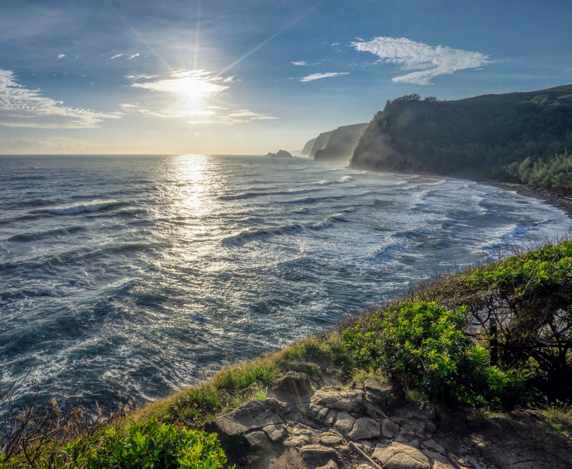
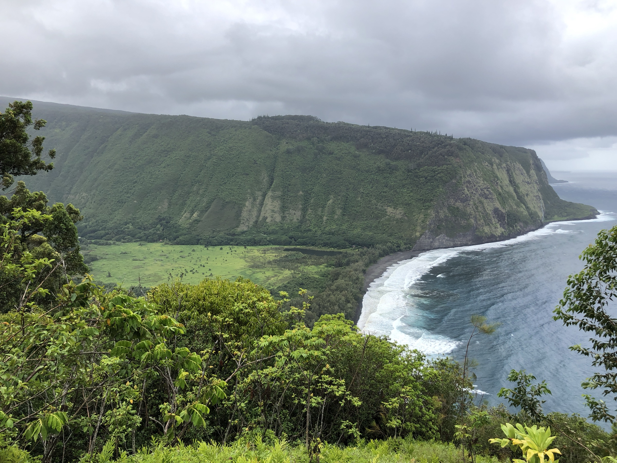
The selection below combines legal public state-park walks, native-forest highland trails, and one private paid Onomea valley garden walk. Waipiʻo valley-floor and Muliwai / Waimanu-style routes are not treated as normal public day hikes because access rules, road restrictions and land tenure are sensitive and changeable; the Waipiʻo Valley Lookout (visible in the cover image) remains a public scenic viewpoint rather than a hiking trailhead. Hakalau Forest National Wildlife Refuge is also not selected because the official refuge page states no routine public access.
For the dry leeward volcanic counterpart, see the companion Kona and Kaʻū coast day-hikes entry where it exists, and for the high summit and crater country see the Hawaiʻi Volcanoes National Park summit catalogue.
Selection rationale
The five-route list keeps to walks that have a clearly legal, publicly accessible footprint: ʻAkaka Falls for the signature waterfall loop; Kalōpā for the easiest public native-forest walk in the highlands; Kaulana Manu for the compact Saddle Road birding loop; Onomea Valley for the private-but-public-access tropical garden network; and a Puʻu ʻŌʻō Trail section hike for the only genuine all-day highland forest route in the region with verifiable public access.
Summary table
| # | Hike | Country | Route type | Distance | Gain | Max elevation | Difficulty |
|---|---|---|---|---|---|---|---|
| 1 | ʻAkaka Falls Loop Trail | USA | Loop | 0.64 km | Stair-stepped paved route | Not stated | Easy to moderate |
| 2 | Kalōpā Nature Trail | USA | Loop | 1.1 km | Not stated | Approx. 610 m park elevation | Easy |
| 3 | Kaulana Manu Nature Trail | USA | Loop | Approx. 1.0 km | Not stated | Not stated | Easy |
| 4 | Onomea Valley garden walk | USA | Loop / linked garden paths | Not stated | Not stated | Not stated | Easy |
| 5 | Puʻu ʻŌʻō Trail highland section | USA | Out-and-back | Up to approx. 24.6 km, shorter turnarounds possible | Not stated | Not stated | Moderate to hard |
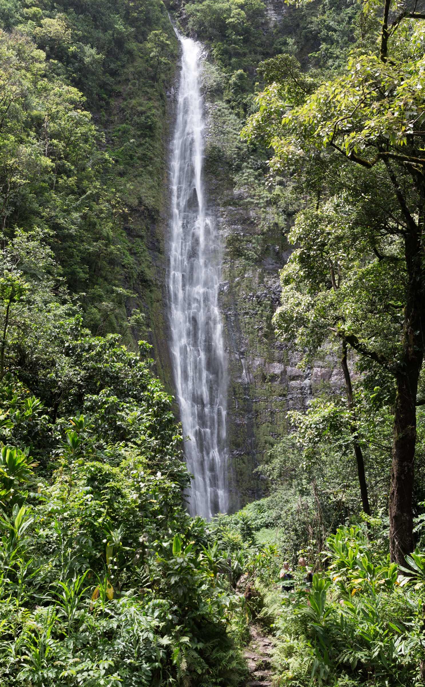
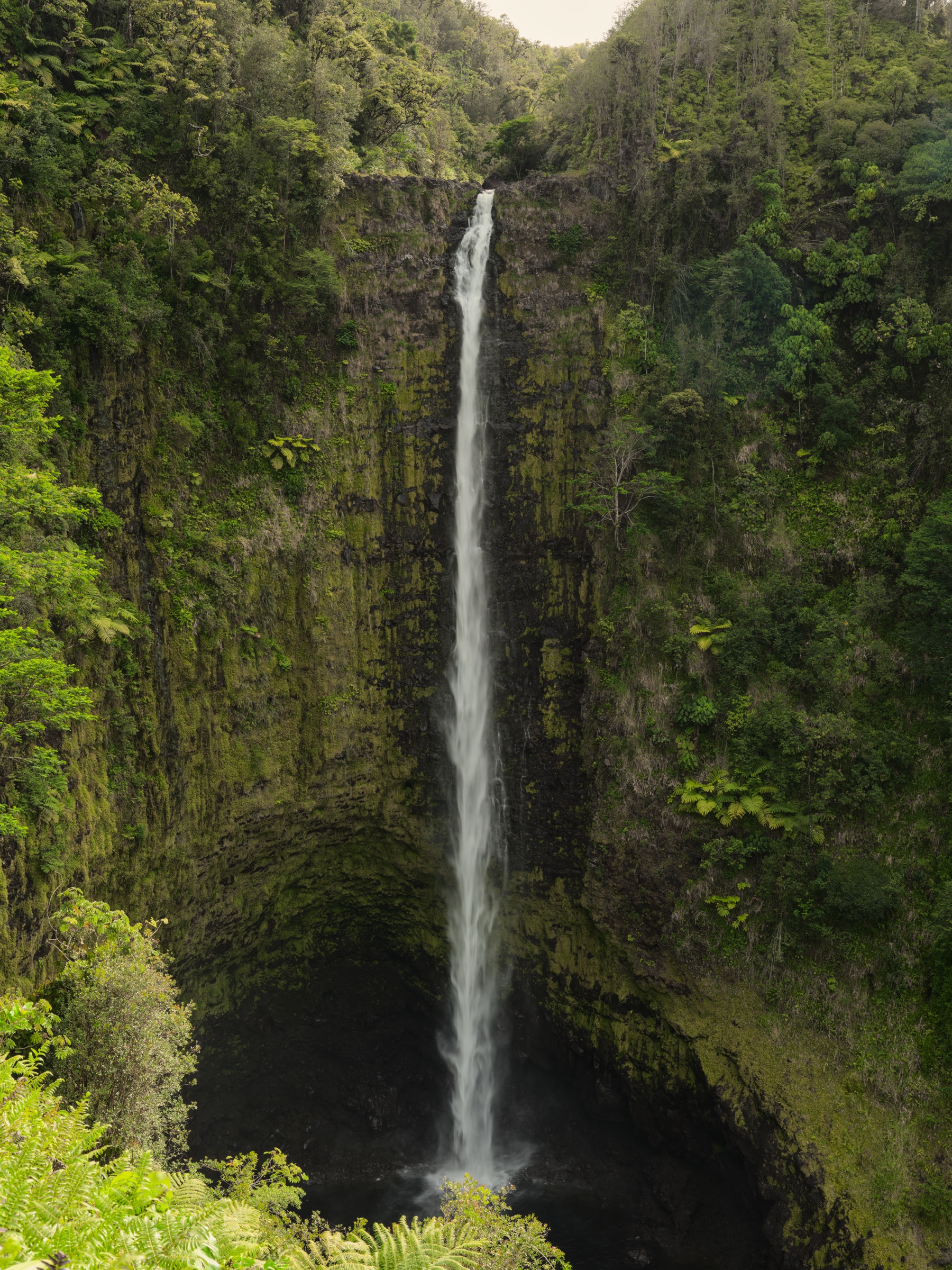
1. ʻAkaka Falls Loop Trail
Snapshot
Itinerary
From the state-park parking area, follow the paved loop through lush tropical vegetation to viewpoints for Kahuna Falls and ʻAkaka Falls. The state page notes that visitors wanting only the ʻAkaka Falls viewpoint can take the left/south path at the first junction.
Why it is essential
ʻAkaka Falls is the signature public waterfall walk of the Hāmākua Coast, with a 135 m plunge into a stream-eroded gorge.
Equipment
Walking shoes with traction, rain layer, water and camera protection.
Hazards and notes
The route includes multiple steps and is not wheelchair accessible. Stay on the paved trail. The state park lists hours and non-resident entry and parking fees; current comfort-station status should be checked before travel.
GPX / KML links
| Source | URL | Format / access | Reuse status |
|---|---|---|---|
| Hawaiʻi DLNR — ʻAkaka Falls State Park | dlnr.hawaii.gov | Official park / route page | State website terms; no GPX found |
| Hawaiʻi DLNR — ʻAkaka Falls Loop Trail | dlnr.hawaii.gov | Official route page | State website terms; no GPX found |
Further reading
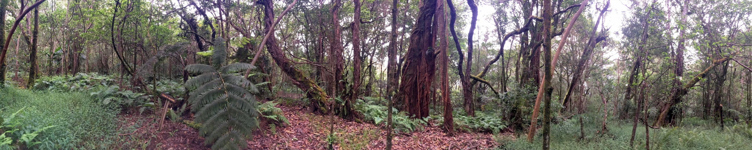
2. Kalōpā Nature Trail
Snapshot
Itinerary
Walk the signed nature loop through native ʻōhiʻa forest and the beginnings of an arboretum of island native plants. The state page notes additional adjoining forest-reserve trails, including a horse loop, but this entry keeps to the verified nature trail.
Why it is essential
Kalōpā is the most accessible public native-forest walk in the Hāmākua highlands and complements the coastal waterfall routes.
Equipment
Closed shoes, light rain layer, water, and clean footwear and gear to reduce Rapid ʻŌhiʻa Death spread.
Hazards and notes
Follow Rapid ʻŌhiʻa Death precautions: clean shoes and gear before and after forest visits, do not move ʻōhiʻa wood, and avoid damaging trees. Camping and cabins require permits but are not needed for this day walk.
GPX / KML links
| Source | URL | Format / access | Reuse status |
|---|---|---|---|
| Hawaiʻi DLNR — Kalōpā State Recreation Area | dlnr.hawaii.gov | Official park / route page | State website terms; no GPX found |
Further reading
3. Kaulana Manu Nature Trail
Snapshot
Itinerary
Follow the signed forest nature trail through highland wet forest bird habitat. The Hawaiʻi Birding Trails page identifies Kaulana Manu as a hotspot for native birds and links it to the state trail system.
Why it is essential
This is the compact, legal highland birding walk for the Hāmākua and Waipiʻo-side forest zone: short, accessible and representative of the native wet-forest bird habitat that defines the higher slopes.
Equipment
Closed shoes, light rain layer, water, binoculars, and cleaned footwear to reduce forest-disease spread.
Hazards and notes
Forest trails can be muddy and slippery. Protect native forest by staying on trail and cleaning gear.
GPX / KML links
| Source | URL | Format / access | Reuse status |
|---|---|---|---|
| Hawaiʻi Birding Trails — Kaulana Manu Nature Trail | hawaiibirdingtrails.hawaii.gov | Official birding / trail information page | Website terms not checked; no GPX found |
| AllTrails — Kaulana Manu Nature Trail | alltrails.com | Secondary route map | AllTrails terms; GPX reuse not verified; source/check only |
Further reading
4. Onomea Valley garden walk
Snapshot
Itinerary
Walk the authorised paths through the Hawaiʻi Tropical Bioreserve & Garden in Onomea Valley. The official garden source identifies the site as a tropical botanical preserve and garden with thousands of plant species in a coastal Hāmākua valley setting.
Why it is essential
Onomea is one of the most recognisable legal public-access ways to experience the lush Hāmākua coastal-valley landscape without trespassing on informal trails.
Equipment
Comfortable walking shoes, rain layer, water and insect protection.
Hazards and notes
This is a private paid site rather than a public backcountry trail. Follow garden rules; do not treat nearby informal valley routes as public hiking access unless separately verified.
GPX / KML links
| Source | URL | Format / access | Reuse status |
|---|---|---|---|
| Hawaiʻi Tropical Bioreserve & Garden | htbg.com | Official site / access source | Private website terms; no GPX found |
Further reading
5. Puʻu ʻŌʻō Trail highland section
Snapshot
Itinerary
Use the Puʻu ʻŌʻō Trail as a highland wet-forest and lava-flow section hike, turning around at a time-appropriate point unless completing the long route. The Hawaiʻi Birding Trails site identifies Puʻu ʻŌʻō as a wet-forest hotspot with hiking access; the long distance and time values here come from a secondary AllTrails listing surfaced during research and should be reconfirmed from a direct route page before any committing trip plan.
Why it is essential
Among the legal highland forest routes, Puʻu ʻŌʻō is the one that turns the region from short waterfall and nature loops into a real day hike across native wet-forest and volcanic terrain.
Equipment
Hiking shoes or boots, rain shell, warm layer, water, food, navigation, headlamp, and cleaned footwear and gear for forest-disease precautions.
Hazards and notes
Navigation, weather and mud can make the long route serious. Treat the stated long-distance statistics as secondary until reconfirmed from a direct route page or official state trail listing.
GPX / KML links
| Source | URL | Format / access | Reuse status |
|---|---|---|---|
| Hawaiʻi Birding Trails — Puʻu ʻŌʻō | hawaiibirdingtrails.hawaii.gov | Official birding / trail-system source | Website terms not checked; no GPX found |
| AllTrails listing noted during research | alltrails.com | Secondary route database | AllTrails terms; GPX reuse not verified; direct route page unresolved |
Further reading
Missing data / follow-up work
- No official GPX/KML downloads were found for any of the five routes.
- Waipiʻo valley-floor routes, Muliwai/Waimanu access and Hakalau Forest refuge access should be rechecked directly before any future inclusion.
- The Onomea and Puʻu ʻŌʻō entries need stronger route-stat verification before being treated as fully verified.
- Kaulana Manu, Onomea, and the Puʻu ʻŌʻō Trail have no licence-compatible open imagery on Wikimedia Commons at the required resolution; route-specific open photography for those three remains a gap.
Further reading
| Resource | Link |
|---|---|
| Hawaiʻi DLNR — ʻAkaka Falls State Park | dlnr.hawaii.gov |
| Hawaiʻi DLNR — ʻAkaka Falls Loop Trail | dlnr.hawaii.gov |
| Hawaiʻi DLNR — Kalōpā State Recreation Area | dlnr.hawaii.gov |
| Hawaiʻi Birding Trails — Kaulana Manu | hawaiibirdingtrails.hawaii.gov |
| Hawaiʻi Tropical Bioreserve & Garden | htbg.com |
| USFWS — Hakalau Forest National Wildlife Refuge | fws.gov |