Regional overview
Kīpahulu and east Maui form the wet, ocean-facing flank of Haleakalā: rainforest streams, bamboo, waterfalls, lava coast, black-sand coves, Hāna cultural sites, and short nature trails along the road to Hāna. This is not a high-mileage trail region; the essential public walks are often short, but they are highly distinctive and tightly managed by Haleakalā National Park, Hawaiʻi State Parks, the DLNR / Nā Ala Hele trail system, and the National Tropical Botanical Garden. For the dry leeward counterpart on the other side of the island, see the West Maui Mountains day-hikes. Flash flooding, slippery lava, fragile cultural sites, and access reservations are the recurring themes of the region’s hiking practice.
Physical access for almost every walk here funnels through the Hāna Highway / Piʻilani Highway loop, a narrow, slow road that is the limiting factor on every itinerary. Haleakalā National Park charges a vehicle entrance fee at the Kīpahulu District, valid for three days and shared with the summit district. Waiʻānapanapa State Park requires advance entry and parking reservations for non-resident day visitors through the Hawaiʻi state booking system, and slots fill days ahead in high season. The rainy season runs roughly November to April, with frequent and intense rainfall on this windward flank — the practical drier window is May to October, but flash-flood watches and storm closures can land in any month. Build slack into the schedule.
Selection rationale
The five walks below were chosen to balance the catalogue across east Maui’s defining landscapes rather than cluster on a single park or theme: one signature waterfall and bamboo-forest trail in the Kīpahulu rainforest, one short coastal-cultural loop in the same national park unit, one rugged lava coast walk at Waiʻānapanapa, one compact Road-to-Hāna nature trail at Waikamoi, and one cultural garden walk at Kahanu that ties Hāna’s living landscape to the largest ancient structure in Polynesia. Together they cover the rainforest, the lava coast, the roadside forest and the cultural anchor without any one walk doing more than its share.
Summary table
| # | Hike | Country | Route type | Distance | Gain | Max elevation | Difficulty |
|---|---|---|---|---|---|---|---|
| 1 | Pīpīwai Trail to Waimoku Falls | United States | Out-and-back | 6.4 km | 244 m | ~300 m | Moderate |
| 2 | Kūloa Point Trail / ʻOheʻo Gulch | United States | Short loop | 0.8 km | 24 m | Low coastal | Easy |
| 3 | Ke Ala Loa O Maui / Piʻilani Trail at Waiʻānapanapa | United States | Coastal out-and-back | 4.8 km | 61 m | Low coastal | Moderate |
| 4 | Waikamoi Ridge Trail | United States | Out-and-back nature trail | 1.3 km | 61 m | — | Easy |
| 5 | Kahanu Garden / Piʻilanihale Heiau self-guided walk | United States | Garden / cultural loop | 1.0 km | 21 m | Low coastal | Easy |
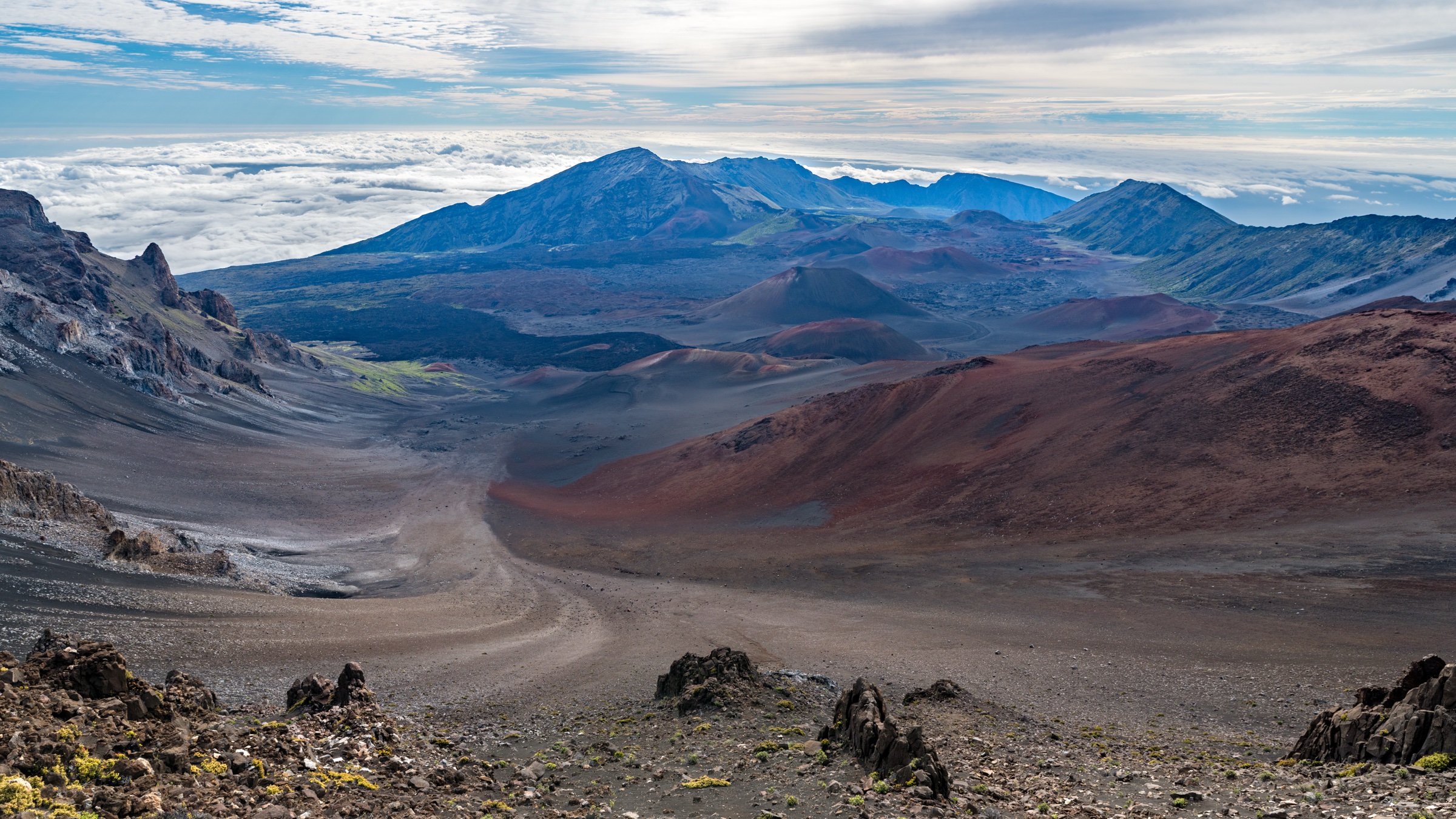
1. Pīpīwai Trail to Waimoku Falls
Snapshot
Itinerary
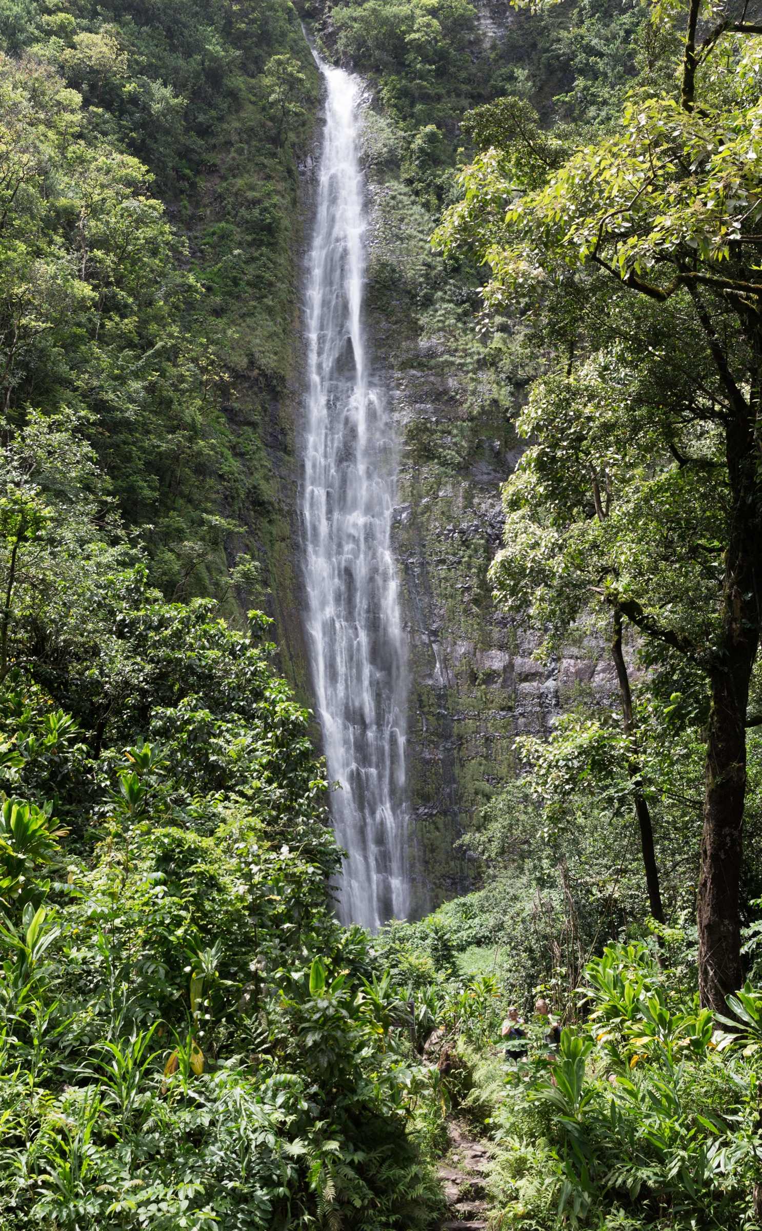
The trail climbs from Kīpahulu through forest and stream country, passes Makahiku Overlook at about 0.5 mi (0.8 km), enters the bamboo forest around 1 mi (1.6 km) in, and reaches the Waimoku Falls viewing area after 2 mi (3.2 km) one way. The bamboo section is the visual centrepiece — a long boardwalk through a dense, creaking grove that fills the middle of the walk — and the upper amphitheatre under Waimoku, with its slender 122 m ribbon falling into a boulder-floored basin, closes the route.
Why it is essential
This is the iconic Kīpahulu hike — freshwater stream, bamboo boardwalk, waterfall viewpoints, and the most dramatic legal day-walk on the wet flank of Haleakalā. It also functions as the spine of the Kīpahulu District for any visitor not staying overnight: pair it with the Kūloa Point loop and you have covered the unit’s public hiking.
Equipment
- Hiking shoes with grip; the boardwalk and bridges are slick when wet
- Rain protection — the windward flank is wet year-round
- Water and snacks
- Sun protection above the bamboo grove
- Insect protection (mosquitoes near streams)
- Offline map; cell coverage is unreliable in the gulch
Hazards and notes
- Flash floods on the streams crossing the trail; do not enter water if it looks turbid or rising.
- Rockfall around the Waimoku Falls amphitheatre — do not approach the base of the falls.
- Slippery boardwalks and bridges through the bamboo grove.
- Off-trail travel is illegal and dangerous, and pets are prohibited on park trails.
GPX / KML links
| Source | URL | Format | Reuse status |
|---|---|---|---|
| Official NPS hiking page | nps.gov | Page (no GPX) | Official route, stat and access reference |
| Official NPS conditions page | nps.gov | Page | Current-condition reference |
| AllTrails (secondary) | alltrails.com | Route page | AllTrails terms; geometry not reused, stats cross-check only |
Further reading
- NPS Haleakalā — hiking
- NPS Haleakalā — conditions and alerts
- AllTrails — Waimoku Falls via Pīpīwai Trail
2. Kūloa Point Trail / ʻOheʻo Gulch
Snapshot
Itinerary
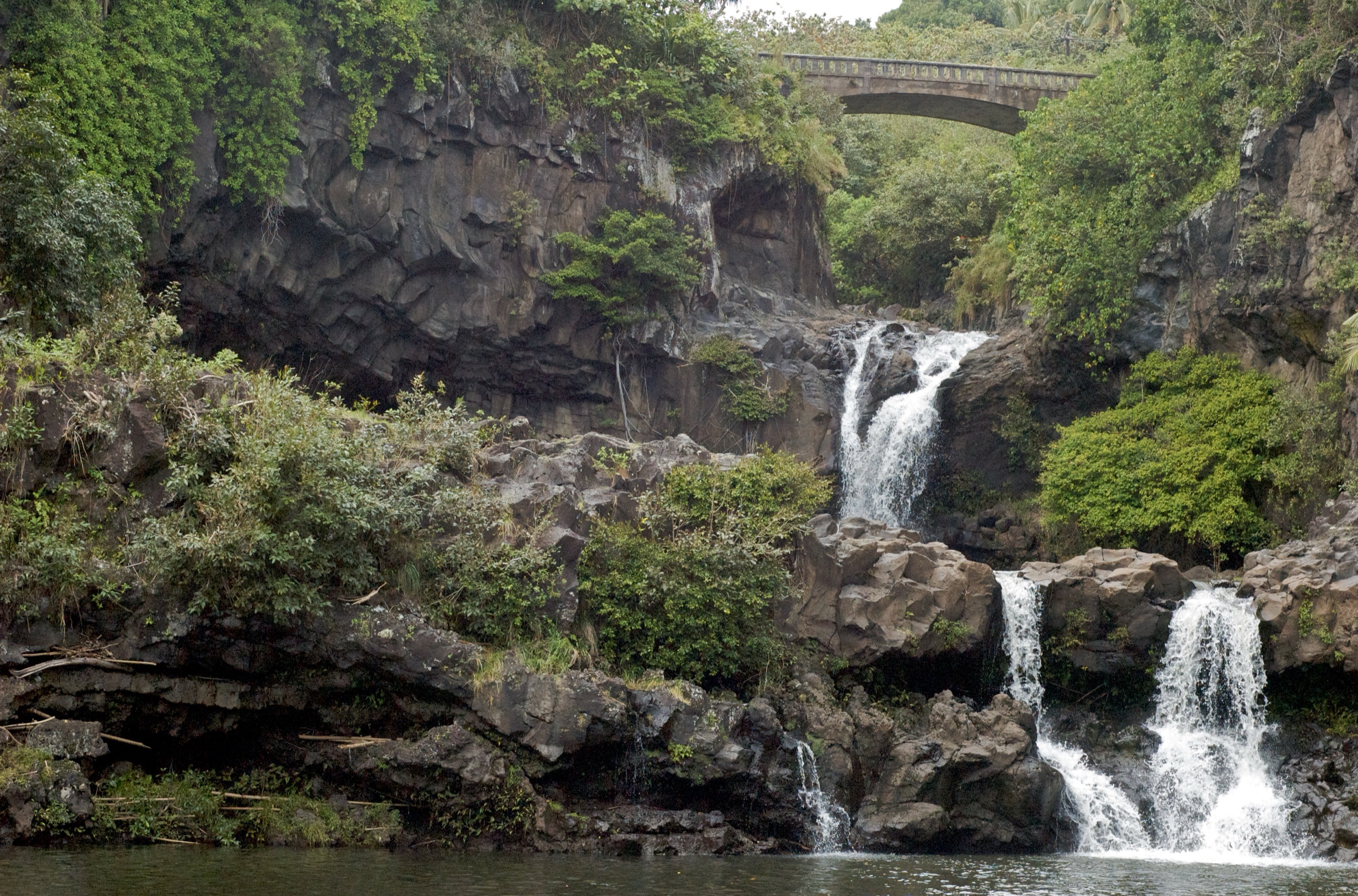
The trail leaves the Kīpahulu Visitor Center, passes a Hawaiian cultural demonstration area, and continues to Kūloa Point at the mouth of ʻOheʻo Gulch for ocean views, archaeological context, and safe viewing of the Pools of ʻOheʻo. The full circuit is short enough to fit in a half-hour but earns much longer if you take the time to read the interpretive panels on the cultural landscape.
Why it is essential
The short official walk that explains Kīpahulu’s coastal archaeology and the famous ʻOheʻo Gulch without entering hazardous pool areas. As a pairing with Pīpīwai it gives the visitor the full Kīpahulu unit in a single morning or afternoon.
Equipment
- Walking shoes
- Sun and rain protection
- Water
Hazards and notes
- ʻOheʻo pools are not currently accessible for swimming per the NPS conditions page; view from Kūloa Point.
- Cliff and stream hazards at the gulch lip.
- Respect cultural sites — stay on the marked trail and do not climb on stone features.
- Pets prohibited on park trails.
GPX / KML links
Further reading
3. Ke Ala Loa O Maui / Piʻilani Trail at Waiʻānapanapa
Snapshot
Itinerary
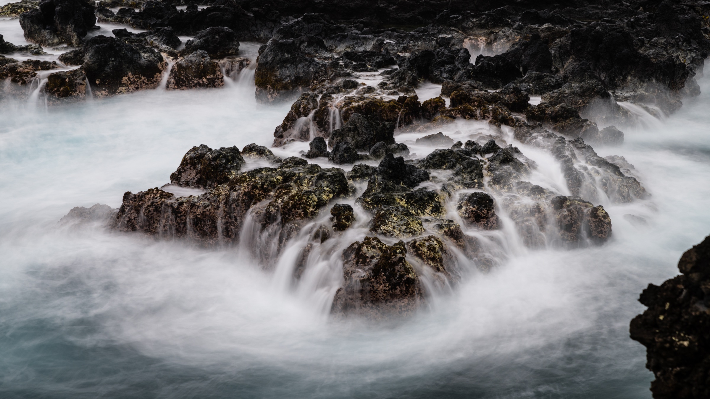
From the state park, reach the shoreline at Pailoa Bay and head southeast along the rugged lava coast. The route passes cabins and cultural sites, including ʻŌhala heiau inland of the trail, before reaching a boulder beach that marks the usual turnaround. Footing alternates between packed earth, lava slab and uneven cobble; pace is dictated by the terrain rather than distance.
Why it is essential
The classic east Maui lava-coast hike — black shoreline, hala groves, sea stacks, an old coastal travel corridor, and a direct visual connection between the Hāna coast and the Haleakalā slopes inland. It also brings the visitor onto a working segment of the ancient Ke Ala Loa O Maui, the island’s coastal travel route.
Equipment
- Sturdy shoes for lava terrain
- Sun protection
- Water
- Rain shell
- Respect for cultural sites — no climbing on stone walls or platforms
Hazards and notes
- Jagged lava and uneven footing throughout.
- Cliff and shoreline exposure; do not approach blowholes during high surf.
- Cultural sites and gravesites are common along the trail — stay outside low stone walls and platforms.
- The Waiʻānapanapa reservation system caps daily entry; plan ahead.
GPX / KML links
| Source | URL | Format | Reuse status |
|---|---|---|---|
| Official DLNR hiking page | dlnr.hawaii.gov | Page (no GPX) | Route, stat and access source |
| Official Waiʻānapanapa park page | dlnr.hawaii.gov | Page | Reservation reference |
| AllTrails (secondary) | alltrails.com | Route page | Geometry not reused |
Further reading
- DLNR — Ke Ala Loa O Maui / Piʻilani Trail
- DLNR — Waiʻānapanapa State Park
- AllTrails — Waiʻānapanapa coast trail (south)
4. Waikamoi Ridge Trail
Snapshot
Itinerary
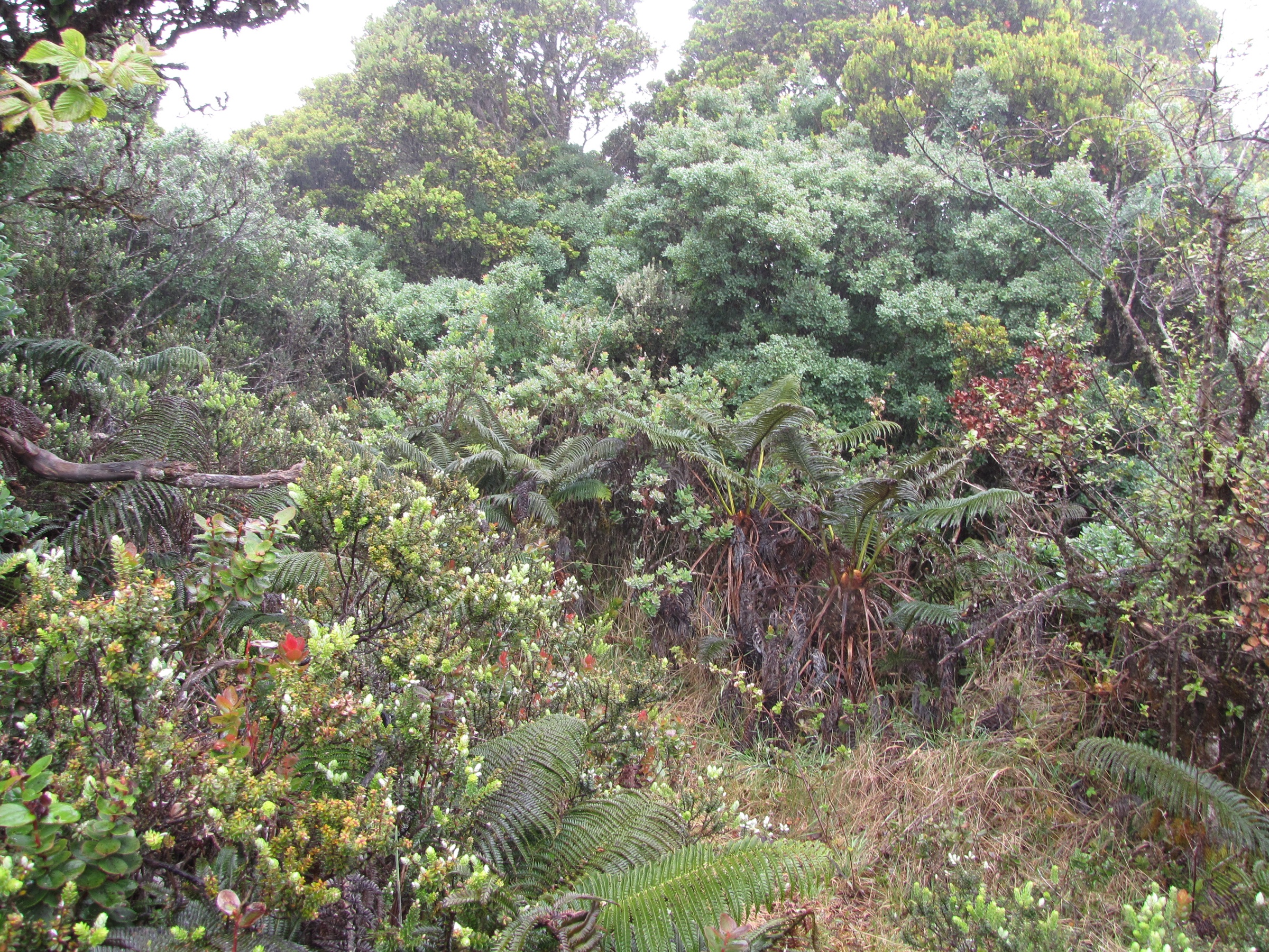
From the picnic shelter the nature trail climbs a forested slope through planted trees and bamboo, then breaks out into a grassy clearing with another shelter and picnic site before returning the same way. The trail is short enough to fit between two longer Hāna stops and gives the only mid-elevation forest sample of the route without leaving the highway corridor.
Why it is essential
The compact forest counterpart to the coast and waterfall routes — useful for showing east Maui’s wet roadside forest ecology without committing to a long walk. As a Road-to-Hāna stop it also breaks up the drive without adding more than an hour of footwork.
Equipment
- Walking or hiking shoes with mud grip
- Rain shell
- Water
Hazards and notes
- Mud, roots and slick forest tread; the upper grass clearing can be slippery in steady rain.
- No water or toilets at the trailhead, no camping.
- The parking pullout sits directly on a narrow segment of highway — pull in and out with care.
GPX / KML links
| Source | URL | Format | Reuse status |
|---|---|---|---|
| Official DLNR / Nā Ala Hele Maui map (PDF) | dlnr.hawaii.gov | PDF map (©2010 Nā Ala Hele, all rights reserved) | Source-map reference only; do not reuse artwork |
| AllTrails (secondary) | alltrails.com | Route page | Geometry not reused |
Further reading
5. Kahanu Garden / Piʻilanihale Heiau self-guided walk
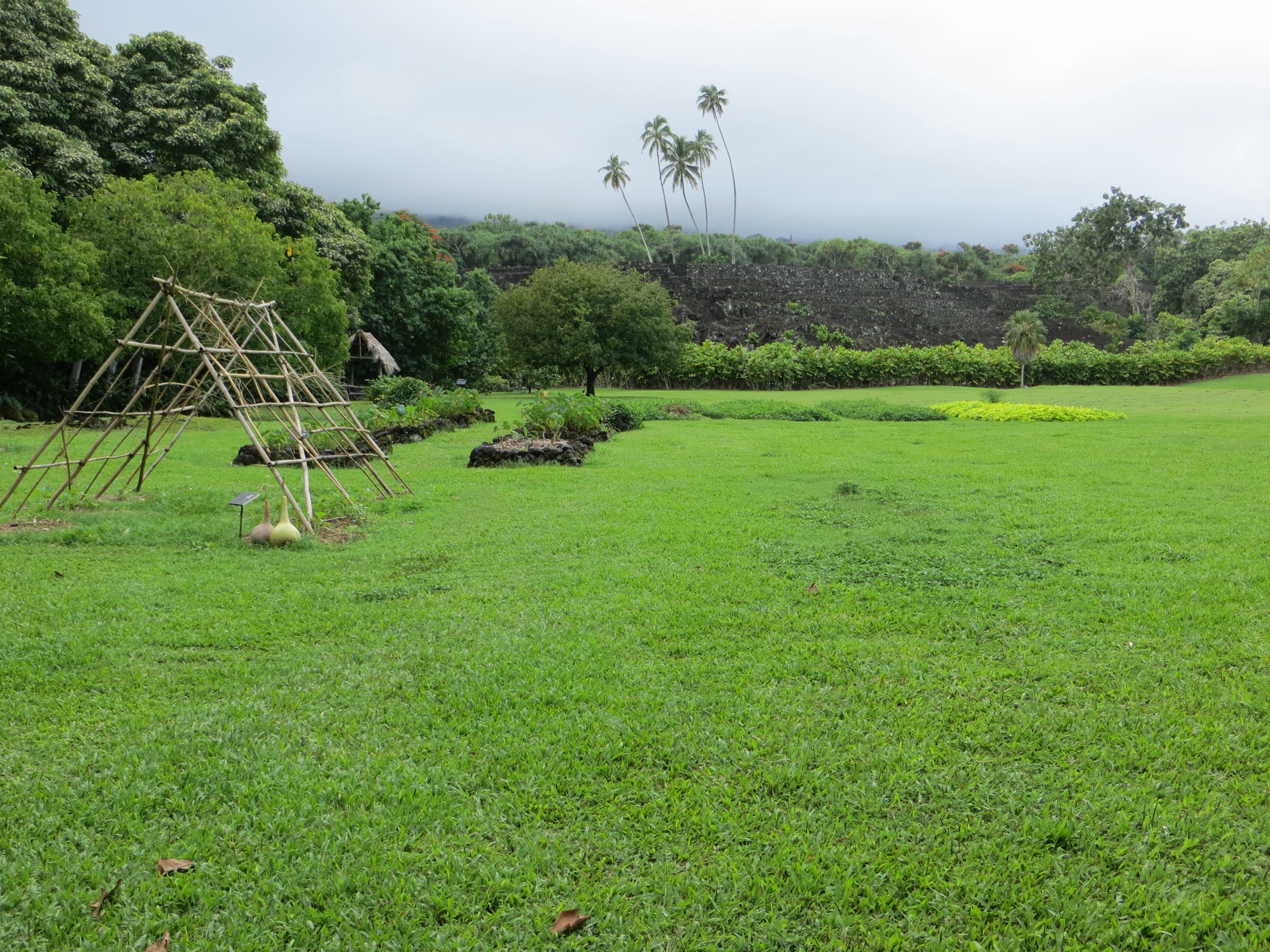
Snapshot
Itinerary
A self-guided walk through Kahanu Garden links canoe plants, Hāna coastal vegetation and views of Piʻilanihale Heiau. NTBG describes the heiau as believed to be the largest ancient structure in Polynesia; the NPS place page identifies it as a National Historic Landmark and one of the most important archaeological sites in the Hawaiian Islands. The walk is short, flat and self-paced.
Why it is essential
The cultural anchor for east Maui’s hiking catalogue — Hāna, canoe plants, Piʻilanihale Heiau and the human landscape behind the coastal and waterfall walks. It is also the one stop on this list that explicitly connects walking with the islands’ deep history rather than treating the landscape as a recreational surface.
Equipment
- Walking shoes
- Sun and rain protection
- Water
- Observe garden and cultural-site rules
Hazards and notes
- Cultural-site protection — do not climb or touch heiau walls.
- Heat and mosquitoes in the lower garden.
- Uneven garden paths in places.
GPX / KML links
| Source | URL | Format | Reuse status |
|---|---|---|---|
| Official NTBG self-guided tour page | ntbg.org | Page | Official access, time and fee source |
| NPS Piʻilanihale Heiau place page | nps.gov | Page | Cultural and historic context |
| AllTrails (secondary) | alltrails.com | Route page | Geometry not reused |
Further reading
Missing data / follow-up
- No official downloadable GPX/KML files were found for the selected routes in this pass.
- The NPS conditions page currently states that the Pools of ʻOheʻo are not accessible for swimming and should be viewed from Kūloa Point Trail.
- East Maui access is unusually road- and reservation-dependent — recheck Hāna Highway / Piʻilani Highway conditions, NPS alerts, Waiʻānapanapa reservations, and NTBG hours before publication.
Further reading
| Source | URL |
|---|---|
| NPS — Haleakalā hiking | nps.gov |
| NPS — Haleakalā conditions and alerts | nps.gov |
| DLNR — Ke Ala Loa O Maui / Piʻilani Trail | dlnr.hawaii.gov |
| DLNR — Waiʻānapanapa State Park | dlnr.hawaii.gov |
| DLNR / Nā Ala Hele — Maui trail map (PDF) | dlnr.hawaii.gov |
| NTBG — Kahanu Garden self-guided tour | ntbg.org |
| NPS — Piʻilanihale Heiau | nps.gov |
| AllTrails — Pīpīwai / Waimoku Falls | alltrails.com |
| AllTrails — Waiʻānapanapa coast trail (south) | alltrails.com |
| AllTrails — Waikamoi Ridge Nature Trail | alltrails.com |
| AllTrails — Kahanu Garden | alltrails.com |
| Wikipedia — Haleakalā National Park | en.wikipedia.org |
| Wikipedia — Waiʻānapanapa State Park | en.wikipedia.org |
| Wikipedia — Piʻilanihale Heiau | en.wikipedia.org |
| Wikipedia — ʻOheʻo Gulch | en.wikipedia.org |
| OpenStreetMap (ODbL 1.0) | openstreetmap.org |