Regional overview
Maroon Bells-Snowmass is the iconic high-Elk Mountains landscape around Aspen, Snowmass, and Crested Butte: red sedimentary peaks, steep passes, aspen groves, alpine lakes, and heavily managed trailheads. The most famous day hikes start from Maroon Lake, but the wilderness also extends through the Castle Creek, Snowmass, and Crystal River drainages. Hiking is high, popular, and often logistically constrained by shuttle, parking-reservation, and overnight-permit systems.
Reservations are required to access the Maroon Bells Scenic Area in season, with private-vehicle trailhead parking permits or RFTA shuttle bookings handled through the Visit Maroon Bells portal referenced by the Aspen Chamber. The Maroon Lake corridor is the busiest entry; quieter starts from Castle Creek and the Snowmass / Crystal River side give the same wilderness without the same crowds. Route statistics in this entry come from structured AllTrails route records unless otherwise stated, with snow on the high passes often persisting into early July and lightning a daily afternoon risk through August. For the broader range overview and the Crested Butte side of the divide, see the companion Aspen and Crested Butte day-hikes entry, and the wilder country west of Kebler Pass is covered in the Raggeds Wilderness day-hikes entry.
Selection rationale
The five hikes cover the essential day-hike spectrum: the classic Maroon Lake to Crater Lake walk, a famous cross-divide pass route, the Buckskin Pass high viewpoint, a long Snowmass Lake approach for very fit day-hikers, and the Castle Creek / Cathedral Lake basin. The list avoids treating the Four Pass Loop as a day hike, while still including one-day sections and objectives that define the wilderness.
Summary table
| # | Hike | Country | Route type | Distance | Gain | Max elevation | Difficulty |
|---|---|---|---|---|---|---|---|
| 1 | Crater Lake | USA | Out-and-back | 6.0 km | 212 m | 3,100 m | Moderate |
| 2 | West Maroon Trail | USA | Point-to-point | 16.7 km | 684 m | 3,811 m | Hard |
| 3 | Buckskin Pass Trail | USA | Out-and-back | 15.0 km | 901 m | 3,799 m | Hard |
| 4 | Snowmass Lake via North Fork Crystal River | USA | Out-and-back | 23.0 km | 1,340 m | 3,788 m | Hard |
| 5 | Cathedral Lake Trail | USA | Out-and-back | 8.9 km | 630 m | 3,632 m | Hard |
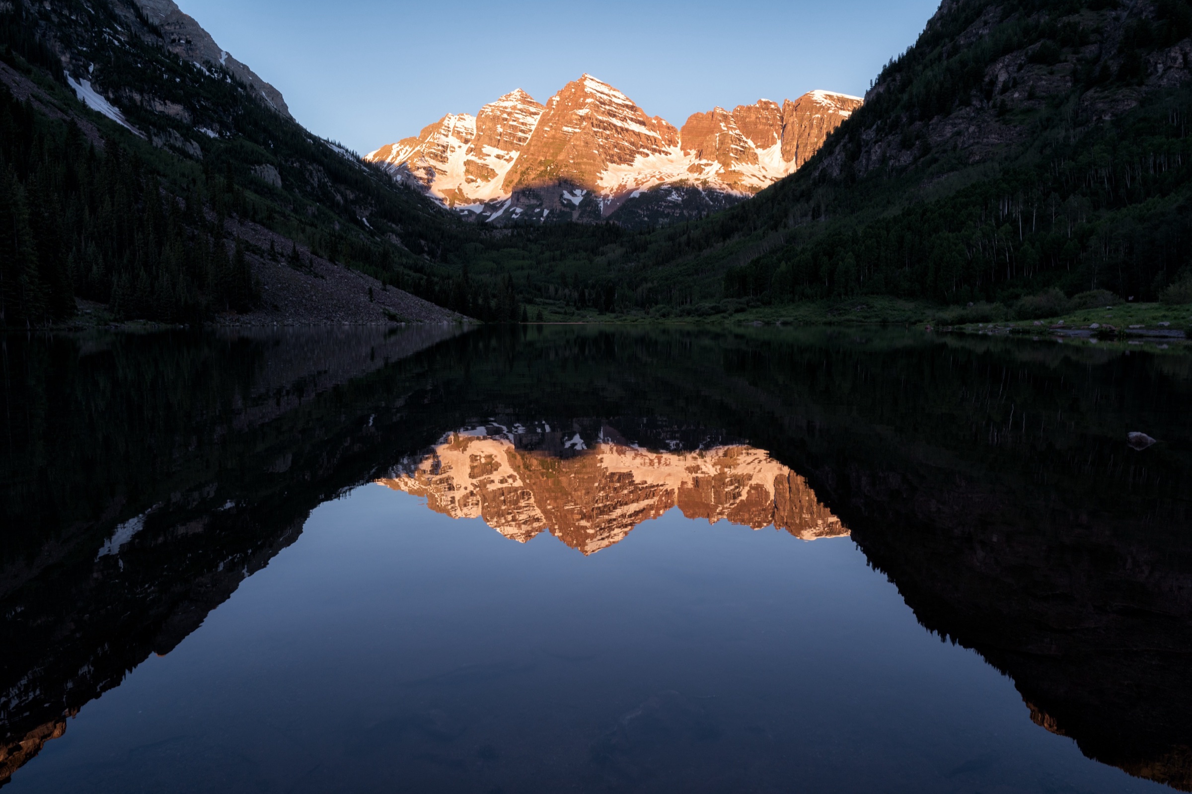
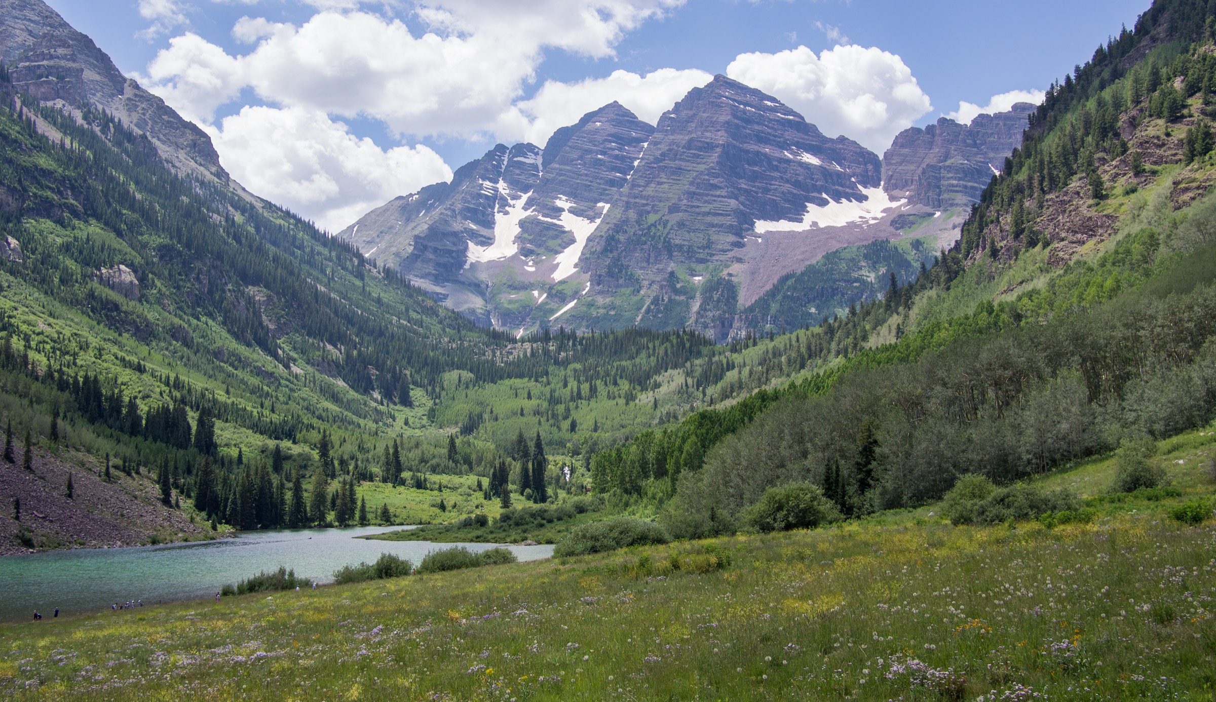
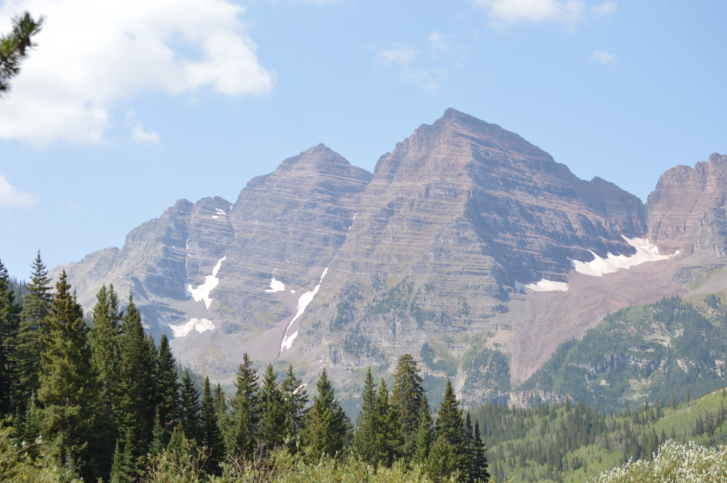
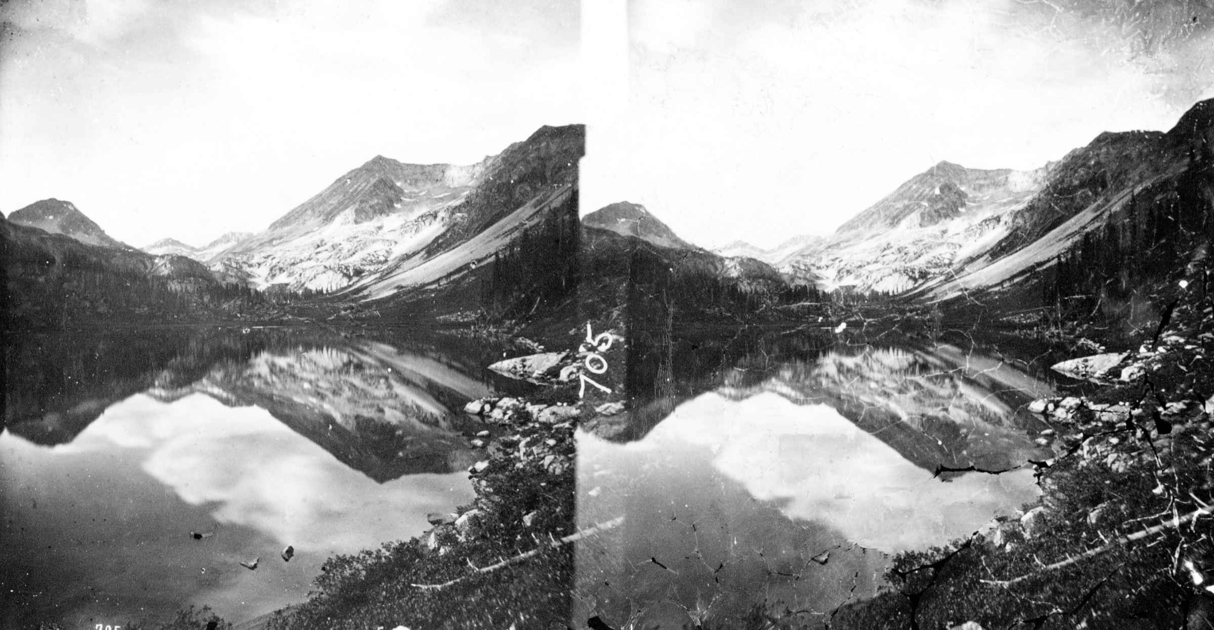
1. Crater Lake
Snapshot
Itinerary
From Maroon Lake, follow the Maroon Snowmass Trail past the famous Maroon Bells view and through aspen and rocky forest terrain to Crater Lake. The lake is the turnaround point for the selected day hike; longer routes continue toward West Maroon, Buckskin, and Four Pass Loop terrain.
Why it is essential
Crater Lake is the signature short hike of the Maroon Bells area. It reaches the classic Bells amphitheatre without requiring a high pass, and it is the normal first step into the wilderness from Maroon Lake.
Equipment
Comfortable hiking shoes, warm or wind layer, waterproof shell, sun protection, water, food, and reservation / access documentation. Early or late season may require traction depending on snow and ice.
Hazards and notes
Crowds, reservation timing, thunderstorms, rockfall and loose terrain around lake margins, altitude, and wildlife food-storage discipline are the main issues. AllTrails notes that leashed dogs are allowed on the trail but not around the lake; confirm current official rules locally.
GPX / KML links
| Source | URL | Format / access | Reuse status |
|---|---|---|---|
| AllTrails: Crater Lake | alltrails.com | Source map / route page | AllTrails terms apply; route-file reuse not confirmed |
| White River NF: Maroon Bells Scenic Area | fs.usda.gov | Official access / rules page | USFS terms; reference only |
| Aspen Chamber: Maroon Bells reservations | aspenchamber.org | Official tourism / access page | Site terms apply; access reference only |
Further reading
- AllTrails — Crater Lake
- Aspen Chamber — Maroon Bells reservations
- Visit Maroon Bells reservation portal
- White River NF — Maroon Bells Scenic Area
2. West Maroon Trail
Snapshot
Itinerary
The selected day hike crosses West Maroon Pass between the Crested Butte / Schofield side and the Aspen / Maroon Lake side. It is a one-way alpine pass traverse, not an out-and-back. The route climbs through flower meadows and high basins to the pass, then descends the opposite drainage.
Why it is essential
West Maroon Pass is one of Colorado’s classic cross-Elk Mountains hiking links and a famous Aspen-Crested Butte passage. It represents the wilderness’ historic pass-travel character better than any short lake walk can.
Equipment
Full mountain day kit, waterproof and windproof layers, warm clothing, sun protection, water treatment, food, headtorch, offline map / GPS, and confirmed shuttle or two-car logistics. Carry enough water capacity for exposed high sections.
Hazards and notes
Snowfields, storms, altitude, creek crossings, shuttle failure, and one-way commitment are the main issues. If snow remains on the pass, the route may require traction, ice-axe skills, or a turnaround depending on conditions.
GPX / KML links
| Source | URL | Format / access | Reuse status |
|---|---|---|---|
| AllTrails: Crested Butte to Aspen via West Maroon Pass | alltrails.com | Source map / route page | AllTrails terms apply; route-file reuse not confirmed |
| White River NF: Maroon Bells Scenic Area | fs.usda.gov | Official access / rules page | USFS terms; reference only |
Further reading
- AllTrails — Crested Butte to Aspen via West Maroon Pass
- Aspen Chamber — Maroon Bells reservations
- White River NF — Maroon Bells Scenic Area
3. Buckskin Pass Trail
Snapshot
Itinerary
From Maroon Lake, follow the Maroon Snowmass Trail corridor toward the wilderness interior, then climb toward Buckskin Pass. The route reaches a high saddle with broad Elk Mountains views, then returns to Maroon Lake by the same route.
Why it is essential
Buckskin Pass is one of the classic high viewpoints above Maroon Lake and a major pass on the Four Pass Loop. As a day hike it gives a true high-pass experience without requiring the full backpacking circuit.
Equipment
Mountain footwear, poles, warm and wind layers, waterproof shell, sun protection, water treatment, food, headtorch, offline map / GPS, and reservation / access documentation. Snow equipment may be needed in early season or after storms.
Hazards and notes
AllTrails notes that steep snow-covered pass sections may require technical equipment or training and that snow or ice can persist depending on snowpack. Lightning exposure, altitude, and crowds near the Maroon Lake corridor are also important.
GPX / KML links
| Source | URL | Format / access | Reuse status |
|---|---|---|---|
| AllTrails: Buckskin Pass Trail | alltrails.com | Source map / route page | AllTrails terms apply; route-file reuse not confirmed |
Further reading
4. Snowmass Lake via North Fork Crystal River
Snapshot
Itinerary
The route approaches Snowmass Lake from the North Fork Crystal River side, climbing into a remote high basin below Snowmass Mountain and the related Elk Mountains summits. The lake is normally associated with backpacking itineraries; as listed here it is a long, strenuous out-and-back day only for very fit hikers with an early start.
Why it is essential
Snowmass Lake is one of the great lake basins of the wilderness. Including the North Fork Crystal River approach gives the region a remote Snowmass-side objective rather than another Maroon Lake start, while staying within the 25 km day-hike ceiling.
Equipment
Full long-day mountain kit: sturdy boots, poles, waterproof and windproof layers, warm clothing, sun protection, water treatment, substantial food, headtorch, offline map / GPS, paper map and compass backup, emergency layer, and a conservative turnaround time.
Hazards and notes
Length, remoteness, route-finding, storms, altitude, snow, creek conditions, and uncertain road / public access are the main issues. If turning this into an overnight, Maroon Bells-Snowmass overnight permits and food-storage rules must be checked through official channels.
GPX / KML links
| Source | URL | Format / access | Reuse status |
|---|---|---|---|
| AllTrails: Snowmass Lake via North Fork Crystal River | alltrails.com | Source map / route page | AllTrails terms apply; route-file reuse not confirmed |
| White River NF: Maroon Bells-Snowmass overnight permit zones | fs.usda.gov | Official permit / rules page | USFS terms; reference only |
Further reading
- AllTrails — Snowmass Lake via North Fork Crystal River
- White River NF — Maroon Bells-Snowmass overnight permit zones
5. Cathedral Lake Trail
Snapshot
Itinerary
From the Cathedral Lake trailhead, the route climbs steeply from the Castle Creek side through forest and alpine terrain to Cathedral Lake below the surrounding Elk Mountains walls. Return by the same trail.
Why it is essential
Cathedral Lake is the classic Castle Creek day hike and gives the catalogue a major objective outside the Maroon Lake reservation corridor. It is shorter than the pass traverses but still reaches a high alpine basin.
Equipment
Sturdy footwear, poles, warm or wind layer, waterproof shell, sun protection, water treatment, food, offline map / GPS, and headtorch.
Hazards and notes
Steep ascent, altitude, storms, lingering snow, and parking pressure are the main concerns. Standard Leave No Trace practice is especially important because this is a popular alpine-lake route.
GPX / KML links
| Source | URL | Format / access | Reuse status |
|---|---|---|---|
| AllTrails: Cathedral Lake Trail | alltrails.com | Source map / route page | AllTrails terms apply; route-file reuse not confirmed |
Further reading
Outstanding verification
- Direct GPX / KML files were not retrieved; AllTrails source maps are route references only, with reuse not confirmed.
- Current White River NF day-use, overnight, dog, food-storage, and closure rules need manual confirmation.
- West Maroon Trail is a point-to-point route; elevation loss was not resolved from the source route record.
- The North Fork Crystal River start and public-road status need manual confirmation before publication.
- No licence-compatible route-specific images were found for Buckskin Pass, Cathedral Lake, or the North Fork Crystal River approach to Snowmass Lake; contextual images are clearly marked in figcaptions where used.
Further reading
- AllTrails — Crater Lake
- AllTrails — Crested Butte to Aspen via West Maroon Pass
- AllTrails — Buckskin Pass Trail
- AllTrails — Snowmass Lake via North Fork Crystal River
- AllTrails — Cathedral Lake Trail
- Aspen Chamber — Maroon Bells reservations
- Visit Maroon Bells reservation portal
- White River NF — Maroon Bells Scenic Area
- White River NF — Maroon Bells-Snowmass overnight permit zones