Regional overview
Rocky Mountain National Park covers 1,075 km² of the northern Colorado Front Range between Estes Park and Grand Lake and contains a near-complete vertical transect of the southern Rocky Mountains from montane ponderosa forest at around 2,400 m to alpine tundra and 4,000 m peaks along the Continental Divide. The park was established by Act of Congress on 26 January 1915 after a long campaign led by Estes Park naturalist Enos Mills; it was designated an International Biosphere Reserve by UNESCO in 1976 and contains 124 named peaks above 3,000 m, 156 lakes and roughly 720 km of officially maintained trail. The defining geological feature is the Front Range crystalline core — Proterozoic gneiss and 1.4-billion-year-old Silver Plume granite uplifted along the eastern margin of the Laramide orogeny and sculpted by Pleistocene valley glaciers into the U-shaped troughs that now hold Bear Lake, Glacier Gorge, Loch Vale and Wild Basin. Longs Peak (4,346 m) is the southernmost fourteener of the Front Range and the only one inside the park; the Continental Divide runs the length of the park from Comanche Peak in the north to Lake Granby in the south, separating the Big Thompson and Cache la Poudre headwaters on the east from the Colorado River headwaters on the west.
The 77 km Trail Ridge Road (US Highway 34) crosses the park from Estes Park to Grand Lake over the Continental Divide at Milner Pass (3,279 m), with 17.4 km of road sustained above 3,350 m and a high point of 3,713 m near Gore Range Overlook — the highest continuously paved through-road in the United States. The road typically opens around Memorial Day (late May) and closes after the first major October snowstorm, restricting cross-park vehicular access in winter to Bear Lake Road on the east side and the lower west-side ranger station road from Grand Lake. The Bear Lake Road corridor concentrates the densest trail network in the park — Bear Lake, Dream Lake, Emerald Lake, Glacier Gorge, Sky Pond, Mills Lake and Black Lake are all reached from Bear Lake or Glacier Gorge trailheads in the upper kilometre of this road — and is consequently the single largest visitor-pressure point in the park.
The 2026 season introduces a refined Timed Entry Permit system that visitors must understand before planning any of the hikes below. The standard Timed Entry permit covers the entire park except the Bear Lake Road corridor and is in force daily from 09:00 to 14:00 from 22 May to 12 October 2026; a separate Timed Entry + Bear Lake Road permit covers the Bear Lake Road corridor itself and runs daily from 05:00 to 18:00 from 22 May to 18 October 2026. Permits are released in monthly tranches on the first day of the preceding month at recreation.gov and a small block is released at 19:00 the night before each entry day. Pre-05:00 or post-18:00 entry to Bear Lake Road does not require a permit but does require a willingness to start very early or finish very late; the standard park entry fee still applies in addition to the permit. The permit window dates and times above are park-published 2026 values; check the official park reservation page for the current season before travel.
Estes Park (2,295 m) on the east side and Grand Lake (2,549 m) on the west are the standard staging towns. Denver International Airport is 110 km south-east of Estes Park by road (around 2 h via Boulder); the closest year-round bus service is the Bustang line from Denver Union Station to Estes Park. Inside the park, a free seasonal shuttle runs from the Estes Park Visitor Center to the Park & Ride and onwards along the Bear Lake corridor — this shuttle is the recommended option for the Bear Lake / Glacier Gorge trailheads, both of which fill before 07:00 on summer mornings even with the permit system in force. The wider context is the central Front Range — see also the southern Front Range Pikes Peak region day-hikes for the lower-elevation granite country south of Denver — and the high western ranges further west, including the Elk Mountains around Maroon Bells and Snowmass and the San Juan Mountains around Ouray, Silverton and Telluride.
Selection rationale
The five hikes below cover the practical day-hiking range of Rocky Mountain National Park from a 5 km lake-basin walk to a 15 km tundra summit, all completable as single days from Estes Park. The selection deliberately spans the four most useful trailhead clusters: Bear Lake (Emerald Lake), Glacier Gorge (Sky Pond), Longs Peak (Chasm Lake) and Milner Pass on Trail Ridge Road (Mount Ida), with Flattop Mountain bridging the Bear Lake corridor and the Continental Divide tundra. Distances run from 5.3 km on the Bear Lake string of lakes to 15.4 km on Mount Ida; gain runs from 218 m to 876 m; maximum elevations span 3,087 m at Emerald Lake to 3,910 m on Mount Ida — so altitude acclimatisation, not technical difficulty, is the main fitness control on the upper three.
The five routes are also chosen for permit fit: Emerald Lake, Sky Pond and Flattop are all inside the Bear Lake Road corridor and require the Timed Entry + Bear Lake Road permit during the corridor’s 05:00–18:00 reservation window; Chasm Lake and Mount Ida lie outside the corridor and require only the standard Timed Entry permit during the 09:00–14:00 entry window, or no permit at all if entry is before 09:00 or after 14:00 on a non-corridor day. Pairing a Bear Lake-corridor day with a non-corridor day across two visits is the cleanest way to walk all five without booking back-to-back corridor permits.
Longs Peak itself (4,346 m via the Keyhole Route) is deliberately excluded from this five-day-hike selection. The standard summit route is 24 km with 1,500 m gain on Class 3 scrambling exposed terrain above the Boulder Field, is held by most guidebooks to be a 12–15 hour day starting before 03:00, and is operationally a non-technical alpine climb rather than a day-hike. Chasm Lake covers the most photographically and atmospherically distinctive third of the Longs Peak corridor — the East Face and the Diamond — without requiring the scrambling commitment of the upper Keyhole.
No park-published GPX tracks are available for the trail network; the most reliable third-party references are AllTrails (terms-restricted, used here for distance / gain / time figures), NPS-published trailhead PDFs and OpenStreetMap (ODbL 1.0, partial summit-area coverage).
Summary table
| # | Hike | Country | Route type | Distance | Gain | Max elevation | Difficulty |
|---|---|---|---|---|---|---|---|
| 1 | Emerald Lake from Bear Lake | USA | Out-and-back | 5.3 km | 218 m | 3,087 m | Moderate |
| 2 | Sky Pond via Glacier Gorge | USA | Out-and-back | 14.5 km | 540 m | 3,315 m | Hard |
| 3 | Chasm Lake under Longs Peak | USA | Out-and-back | 13.5 km | 774 m | 3,598 m | Hard |
| 4 | Flattop Mountain via Bear Lake | USA | Out-and-back | 14.0 km | 876 m | 3,758 m | Hard |
| 5 | Mount Ida from Milner Pass | USA | Out-and-back | 15.4 km | 731 m | 3,910 m | Hard |
1. Emerald Lake from Bear Lake
Snapshot
Itinerary
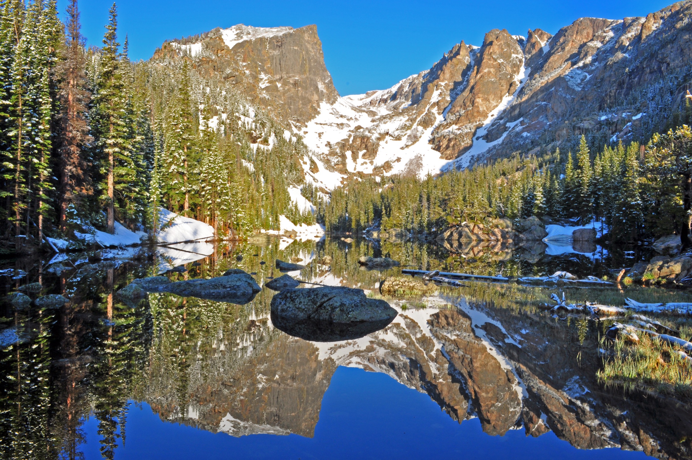
From the Bear Lake trailhead at 2,869 m the path skirts the north shore of Bear Lake clockwise for around 100 m before the signed Emerald Lake junction breaks west and begins the climb. The first kilometre rises through a Engelmann spruce – subalpine fir belt to Nymph Lake at 2,932 m, a small lily-covered tarn often used as the first photographic stop. The path swings north-west above Nymph Lake, contours above a small cliff band and arrives at Dream Lake (2,994 m) at the 1.5 km mark — the classic foreground for the Hallett Peak reflection that defines the Bear Lake area in postcards. From Dream Lake the trail climbs through a more open subalpine bench, crosses Tyndall Creek and arrives at Emerald Lake at 3,087 m and 2.65 km from the trailhead, set in a high cirque directly beneath the east face of Hallett Peak and the north flank of Flattop Mountain. Return is on the same path. Total round trip is 5.3 km with 218 m of cumulative gain.
Why it is essential
Emerald Lake is the highest-impact lake walk in the park for the least time investment, and the only one that strings three high cirque lakes (Nymph, Dream, Emerald) onto a single 5 km loop with continuous Hallett Peak views. It is also the canonical introduction to the Bear Lake corridor — a half-day on this trail builds the mental map for the harder Sky Pond and Flattop days from the same trailhead cluster.
Equipment
- Trail shoes or low boots; the path is well-graded but has rocky steps above Dream Lake
- Light rain shell for afternoon thunderstorms (June–August)
- Sun protection at altitude
- Water (1–1.5 L); no refill points
- Microspikes are useful into late June for lingering snow above Dream Lake
Hazards and notes
The trail is exposed at the upper lakes and lightning is the dominant summer hazard; aim to be back below Dream Lake by 13:00 in July and August. The Bear Lake trailhead parking lot fills before 07:00 on summer weekends even with the permit system; the seasonal shuttle from the Park & Ride is the reliable alternative. Wildlife — particularly bighorn sheep and elk in the early morning — are common in the Dream Lake basin; the park’s standard 75 ft (23 m) viewing distance applies.
GPX / KML links
| Source | URL | Format | Notes |
|---|---|---|---|
| AllTrails — Emerald Lake | alltrails.com | Route page | AllTrails terms; reference only |
| NPS — Bear Lake area trails | nps.gov | NPS PDF | Park-published reference |
| OpenStreetMap — Emerald Lake | openstreetmap.org | OSM | ODbL 1.0 |
Sources
2. Sky Pond via Glacier Gorge
Snapshot
Itinerary
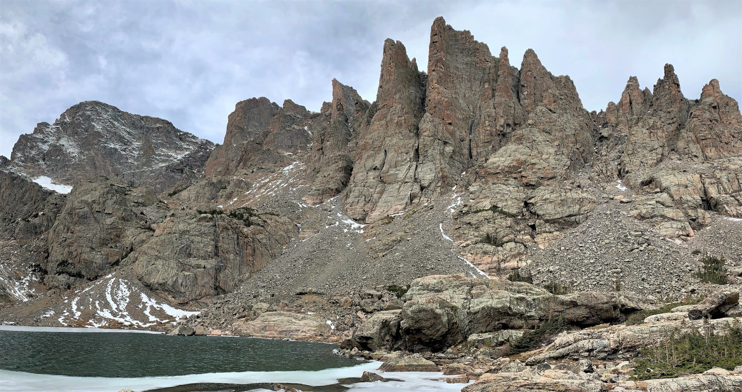
From the Glacier Gorge trailhead at 2,775 m the path climbs south-west to Alberta Falls (1.4 km), a 9 m drop in Glacier Creek that is the first significant landmark on the route and the turnaround for many half-day visitors. Above the falls the trail contours along the east wall of Glacier Gorge through lodgepole pine and Engelmann spruce, passes the North Longs Peak Trail junction at around 3 km, and arrives at Loch Vale (The Loch) at 3,049 m and 4.2 km. From The Loch the trail follows the gorge’s west wall above Icy Brook past Embryo Lake to Timberline Falls at the 6 km mark — a 18 m two-stage waterfall over a granite headwall that requires a 15 m Class 2+ rock scramble on slick polished slabs to gain Lake of Glass directly above. From Lake of Glass (3,283 m) the path traverses the open subalpine bench south-west for 600 m to Sky Pond at 3,315 m, set in a high cirque beneath the Cathedral Spires and the north face of Taylor Peak. Return is on the same route. Total round trip is 14.5 km with 540 m of cumulative gain.
Why it is essential
Sky Pond ties together what is arguably the densest concentration of classic Front Range cirque scenery in the park — Alberta Falls, The Loch, Timberline Falls, Lake of Glass and Sky Pond itself, with Cathedral Spires and Taylor Peak as the backdrop — into a single long day from a single trailhead. The Timberline Falls scramble adds the only Class 2+ section in this five-day-hike selection and provides a useful preview of what the harder objectives in the Front Range feel like above 3,200 m.
Equipment
- Sturdy trail shoes or low boots with good grip for the Timberline Falls slab
- Light rain shell; afternoon thunderstorms are the controlling hazard above The Loch
- Sun protection; the upper basin is fully exposed
- Water (2–2.5 L) and snacks; no refill points
- Light gloves and a wind layer for Sky Pond — the cirque holds wind even on calm days
Hazards and notes
The Timberline Falls scramble is the trip’s main objective hazard. The slab is slick when wet, ice-prone into late June, and a fall onto the granite below the falls is the most common rescue scenario on the route; downclimbing requires more care than the ascent. Above Timberline Falls the trail is exposed and lightning is the controlling hazard from late June through August — be back below Timberline Falls by 13:00 unless skies are clear. The Glacier Gorge trailhead lot is the smallest in the Bear Lake corridor and fills before 06:30 on summer weekends; the park shuttle or an early Bear Lake start with a 200 m walk down the road is the reliable alternative.
GPX / KML links
| Source | URL | Format | Notes |
|---|---|---|---|
| AllTrails — Sky Pond | alltrails.com | Route page | AllTrails terms; reference only |
| NPS — Glacier Gorge area trails | nps.gov | NPS PDF | Park-published reference |
| OpenStreetMap — Sky Pond | openstreetmap.org | OSM | ODbL 1.0 |
Sources
3. Chasm Lake under Longs Peak
Snapshot
Itinerary
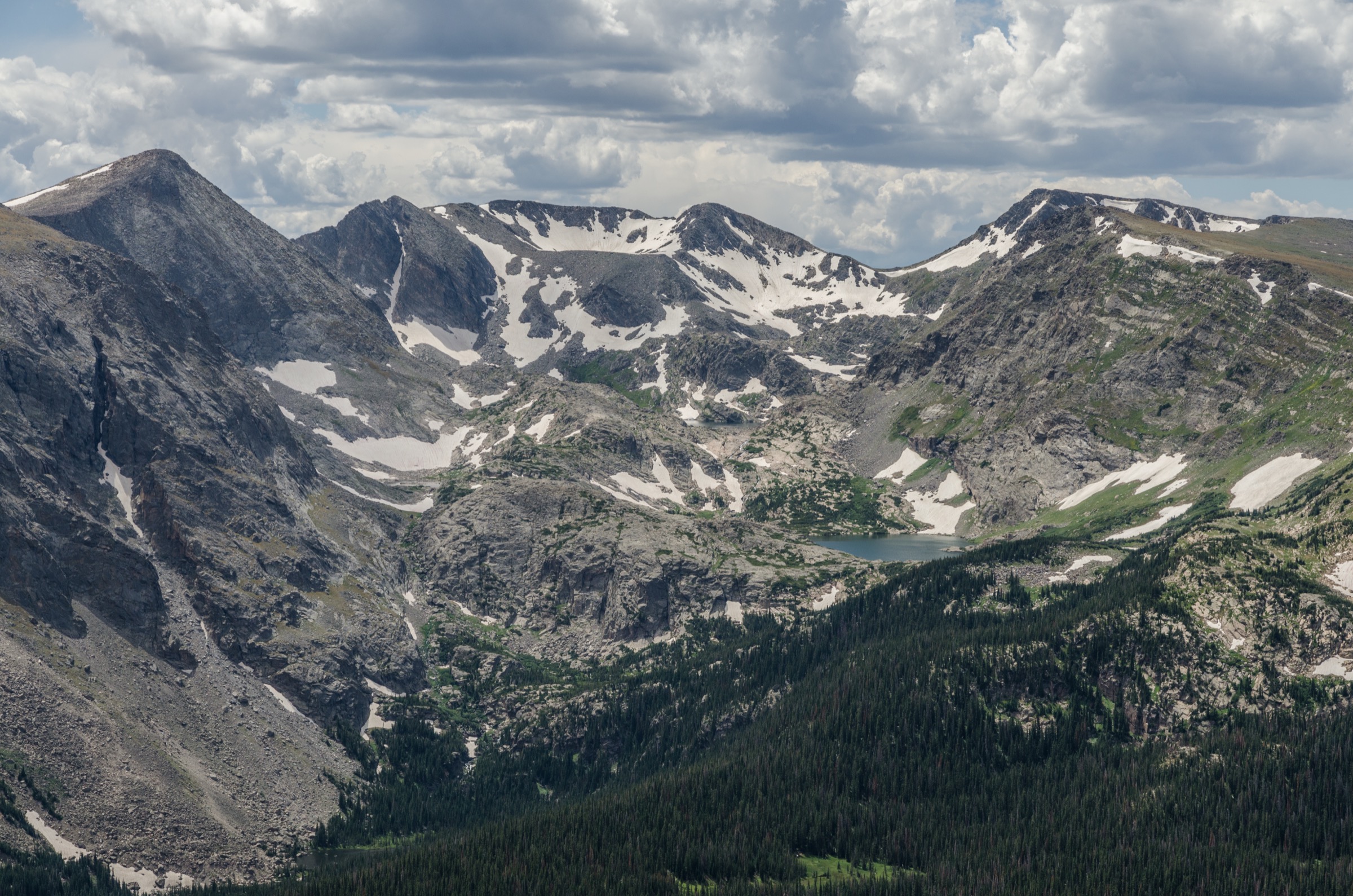
From the Longs Peak trailhead at 2,824 m, 16 km south of Estes Park on Colorado Highway 7, the trail climbs steadily west through lodgepole pine to the Goblins Forest area at around 2 km, crosses Alpine Brook at 3 km, and breaks above treeline at the Mills Moraine traverse around 4 km. At 5.5 km the path reaches Chasm Junction (3,500 m) where the Longs Peak Keyhole Route branches right (north-west) and the Chasm Lake spur breaks left (south-west). The Chasm Lake spur contours south-west along the open tundra above Peacock Pool, crosses the inlet stream feeding Columbine Falls, and arrives at the Chasm Meadows patrol cabin (3,576 m) at the 6.3 km mark. From the cabin a short, well-marked path climbs the last 30 m of granite slab to the Chasm Lake outlet at 3,598 m, directly beneath the 800 m East Face of Longs Peak with the Diamond — the 300 m vertical granite headwall that is the iconic Front Range big-wall feature — rising straight out of the water. Return is on the same path. Total round trip is 13.5 km with 774 m of cumulative gain.
Why it is essential
Chasm Lake gives the single most dramatic on-the-water view of Longs Peak in the park without committing to the 24 km Keyhole Route summit day. The lake sits directly under the Diamond — the only true alpine big-wall in the Front Range — and Columbine Falls, Peacock Pool and the upper Mills Moraine traverse are some of the longest sustained alpine tundra walking in Rocky Mountain National Park. For walkers training for or considering Longs Peak itself, Chasm Lake is the standard reconnaissance day.
Equipment
- Sturdy trail shoes or low boots; the upper tundra has loose granite scree
- Wind shell and warm layer; the Chasm Meadows / lake basin holds wind year-round
- Sun protection — the upper four kilometres are fully exposed
- Water (2 L) and snacks; no refill points
- Microspikes through early July; the Chasm Lake outlet slab can hold patches of ice well into the summer
Hazards and notes
Lightning is the controlling hazard from late June through August and the upper Mills Moraine traverse has no shelter — start in the dark (headlamp departure 04:30–05:30) to be on the descent by 11:00, the standard alpine practice in the Front Range. The Longs Peak trailhead lot fills before 03:00 on weekend nights through summer; arriving after 04:00 typically means parking on the highway shoulder up to 1 km from the trailhead. The final 30 m to Chasm Lake itself is a short Class 2 step on granite slab that holds wet ice into July and is the most common turnaround point for parties not equipped for it. This is not a permit hike — it sits outside the Bear Lake Road corridor — but standard park entry fees apply.
GPX / KML links
| Source | URL | Format | Notes |
|---|---|---|---|
| AllTrails — Chasm Lake | alltrails.com | Route page | AllTrails terms; reference only |
| NPS — Longs Peak | nps.gov | NPS PDF | Park-published reference |
| OpenStreetMap — Chasm Lake | openstreetmap.org | OSM | ODbL 1.0 |
Sources
4. Flattop Mountain via Bear Lake
Snapshot
Itinerary
From the Bear Lake trailhead at 2,869 m the Flattop Mountain Trail branches north-west off the Bear Lake shoreline path within the first 200 m and begins a steady climb through a subalpine fir / Engelmann spruce belt on the eastern flank of Flattop. The first major landmark is the Dream Lake Overlook at 2.4 km (3,165 m), a spur platform that looks south-east into the Bear Lake basin with Hallett Peak and the Emerald Lake cirque framed below; a second spur at the 3.6 km mark gives the Emerald Lake Overlook (3,353 m) looking directly down into the Emerald Lake basin. Above the Emerald Lake Overlook the trail breaks above treeline at around 3,400 m, climbs through the krummholz transition zone, and crosses a long stretch of open alpine tundra for the final 2 km to the rounded Flattop summit cairn at 3,758 m. The summit sits directly on the Continental Divide; the Tonahutu Creek Trail and the North Inlet Trail both descend west from the summit to Grand Lake. Return for a day-hike is on the same path. Total round trip is 14.0 km with 876 m of cumulative gain.
Why it is essential
Flattop is the most accessible Continental Divide summit in the park and the only tundra summit in this five-day-hike selection that is reachable from Bear Lake without leaving the Bear Lake Road corridor — making it the natural pairing with Emerald Lake on a two-day Bear Lake permit. The Dream Lake and Emerald Lake overlooks give the reverse vantage of the lake hikes from above, and the upper tundra is one of the longest sustained alpine tundra walks on the east side of the Divide.
Equipment
- Sturdy trail shoes or low boots; the upper tundra has loose decomposed-granite gravel
- Wind shell and warm layer; the summit ridge holds wind on most days
- Sun protection — the upper four kilometres are fully exposed
- Water (2 L) and snacks; no refill points
- Microspikes through early July for residual snow patches on the upper trail
Hazards and notes
Lightning is the controlling hazard from late June through August and the upper tundra has no shelter — start at first light to be on the descent by 11:00. Flattop is one of the most weather-exposed walks on the Bear Lake corridor and the temperature differential between the trailhead and the summit can run 12–15 °C on a clear August morning. The summit cairn is broad and featureless in low cloud; carry a compass or GPS and note the descent line at the summit. The Bear Lake parking lot fills before 07:00 on summer weekends even with the permit system; the park shuttle is the reliable alternative.
GPX / KML links
| Source | URL | Format | Notes |
|---|---|---|---|
| AllTrails — Flattop Mountain | alltrails.com | Route page | AllTrails terms; reference only |
| NPS — Bear Lake area trails | nps.gov | NPS PDF | Park-published reference |
| OpenStreetMap — Flattop Mountain | openstreetmap.org | OSM | ODbL 1.0 |
Sources
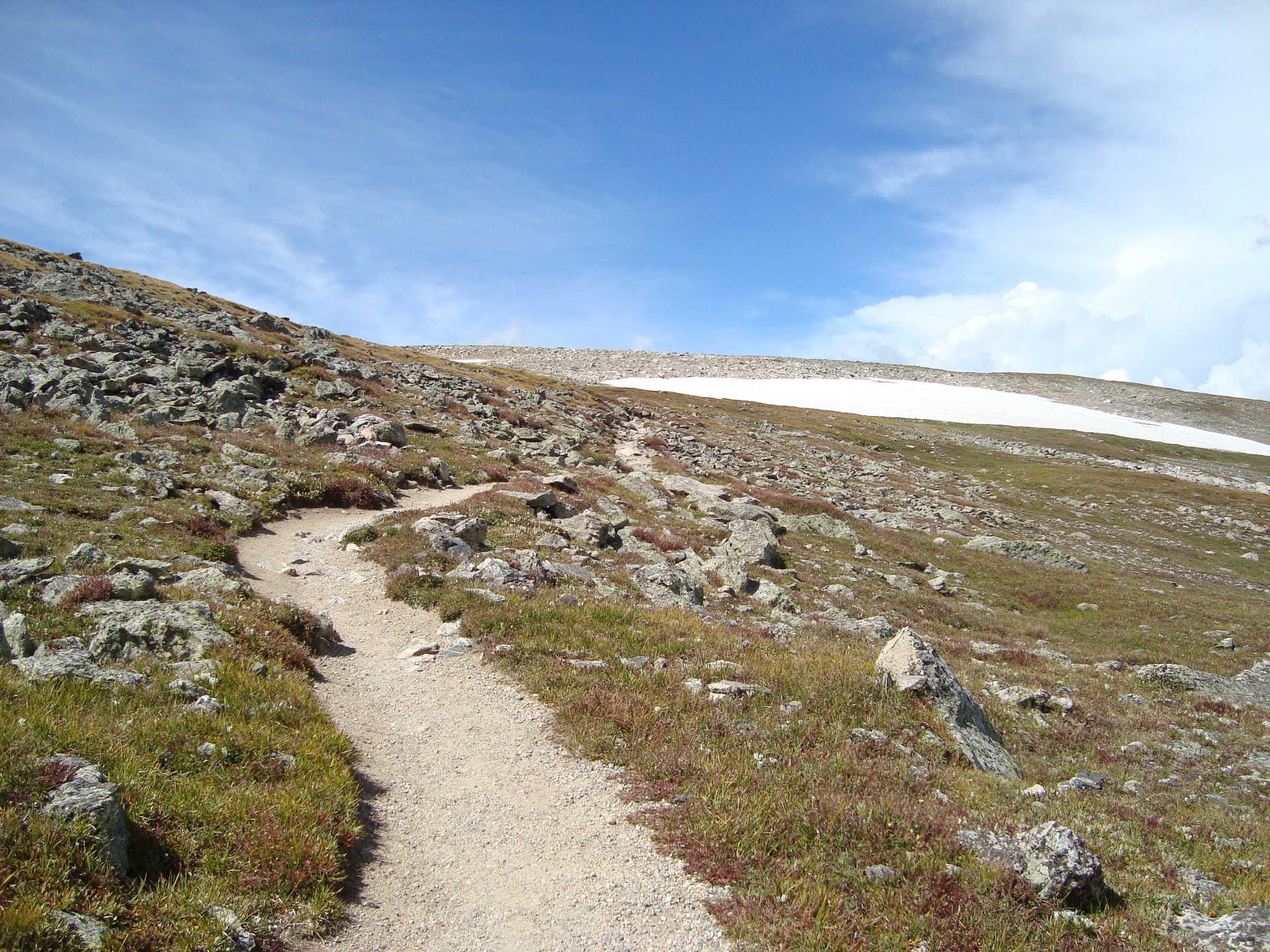
5. Mount Ida from Milner Pass
Snapshot
Itinerary
From the Milner Pass trailhead at 3,279 m on Trail Ridge Road — the Continental Divide crossing midway between Estes Park and Grand Lake — the path climbs steadily south-east through a thinning subalpine fir belt to break above treeline at around 1.5 km. The trail then follows a broad open tundra ridge south-east for 6 km, climbing in stages over a series of false summits, with continuous views east across the Forest Canyon headwaters to Longs Peak and west across the Never Summer Mountains to the Colorado River headwaters. The official Mount Ida Trail ends at around 6 km on a tundra bench; the final 1.5 km to the summit cairn at 3,910 m follows a well-used cairned use-trail south-east along the ridge. The summit is a rounded tundra high point on the Continental Divide directly above Gorge Lakes — a cluster of glacial cirque lakes (Azure, Inkwell, Highest, Arrowhead, Doughnut) draining north-east into Forest Canyon — visible 400 m below. Return is on the same ridge. Total round trip is 15.4 km with 731 m of cumulative gain.
Why it is essential
Mount Ida is the longest sustained alpine tundra ridge walk in the park and reaches the highest summit in this five-day-hike selection at 3,910 m. The ridge gives an unbroken Continental Divide panorama — Longs Peak and Pikes Peak to the south-east, the Mummy Range to the north, the Never Summer Mountains to the west and Grand Lake to the south — that no other day-hike in the park matches. As the only summit in this selection reached from Trail Ridge Road rather than the Bear Lake / Longs Peak side, Mount Ida is the natural high-tundra counterweight to the Bear Lake corridor days.
Equipment
- Sturdy trail shoes or low boots; the upper ridge has loose tundra scree
- Wind shell and warm insulated layer; the ridge holds wind year-round and summit temperatures can sit 15 °C below the trailhead
- Sun protection — the entire route above 1.5 km is fully exposed
- Water (2.5–3 L) and snacks; no refill points
- Light gloves and hat in shoulder season
Hazards and notes
Lightning is the dominant objective hazard and the long open ridge has no shelter — the standard alpine practice is to start by 06:00 and aim to be on the descent by 11:00. Trail Ridge Road opening and closing dates set the access window: opening is typically late May after avalanche clearing but is regularly delayed into early June; closing is after the first major October storm. The summit cairn is one of several similar rises along the ridge and is featureless in low cloud — carry a compass or GPS. Mount Ida sits outside the Bear Lake Road corridor: the standard Timed Entry permit covers it during the 09:00–14:00 entry window from 22 May to 12 October 2026, but a pre-09:00 trailhead arrival (the standard alpine start anyway) does not require a permit.
GPX / KML links
| Source | URL | Format | Notes |
|---|---|---|---|
| AllTrails — Mount Ida | alltrails.com | Route page | AllTrails terms; reference only |
| NPS — Trail Ridge Road | nps.gov | NPS PDF | Park-published road / access reference |
| OpenStreetMap — Mount Ida | openstreetmap.org | OSM | ODbL 1.0; partial summit-area coverage |
Sources
Missing data / follow-up work
- Timed Entry and Timed Entry + Bear Lake Road permit window dates and times above are the park-published 2026 values; the system is reviewed annually and the 2027 windows should be re-checked at the official park reservation page before travel.
- Trail Ridge Road opening and closing dates are weather-dependent and vary by 2–3 weeks year to year; the late-May opening date for the Mount Ida access window is an average rather than a guaranteed date.
- Distance, gain and time figures above are sourced from AllTrails and NPS trailhead PDFs; AllTrails values for several entries differ from older NPS estimates by 0.3–0.6 km and 20–40 m due to GPS-track sampling. Where the two disagree, the AllTrails figure has been used here.
- Chasm Lake outlet slab conditions vary year to year; verify recent trip reports for ice cover before committing to the final 30 m.
- Timberline Falls slab on the Sky Pond route is the controlling difficulty rating on that hike; the Class 2+ grade above is conservative and parties uncomfortable with wet polished granite should treat Lake of Glass as the practical turnaround.
- Mount Ida cairned use-trail above the official trail end is not maintained by the NPS; the route is conventional but is not signed and a GPS track is the safest navigational reference.
Further reading
| Source | URL |
|---|---|
| NPS — Rocky Mountain National Park | nps.gov |
| NPS — Rocky Mountain Timed Entry Permit System | nps.gov |
| NPS — Bear Lake Area Trails | nps.gov |
| NPS — Longs Peak | nps.gov |
| NPS — Trail Ridge Road | nps.gov |
| Wikipedia — Rocky Mountain National Park | en.wikipedia.org |
| Wikipedia — Longs Peak | en.wikipedia.org |
| Wikipedia — Trail Ridge Road | en.wikipedia.org |
| AllTrails — Rocky Mountain National Park trails | alltrails.com |
| Wikimedia Commons — Category:Rocky Mountain National Park | commons.wikimedia.org |
| OpenStreetMap — Rocky Mountain National Park | openstreetmap.org |