Regional overview
The inland Southern Coast Ranges are the semi-arid, chaparral-and-oak backbone that runs south from the Diablo Range behind the Bay Area, through the Gabilan Range east of Salinas and the volcanic core of Pinnacles National Park, into the San Rafael Wilderness and the empty Caliente Range above the Cuyama Valley. They are geologically and climatically distinct from the fog-drenched Santa Lucia coast: the ridges here sit in the rain shadow of the outer ranges, receiving 300–500 mm of annual rainfall, and the summit landscapes are grass, chamise, blue oak and manzanita rather than redwood or Douglas-fir. The highest points — San Benito Mountain (1,598 m) in the Diablo Range, Caliente Mountain (1,556 m) in the Caliente Range and Big Pine Mountain (2,077 m) in the San Rafael Wilderness — are modest by California standards, but the topography is steep, folded and remote.
The core walking centres are Pinnacles National Park astride the Gabilan/Diablo divide, Henry W. Coe State Park in the northern Diablo Range, Fremont Peak State Park at the northern end of the Gabilan Range, and the Nira / Sunset Valley trailhead cluster on the southern edge of the San Rafael Wilderness in Los Padres National Forest. Carrizo Plain National Monument holds the Caliente Ridge trail on BLM land. Trails are typically dirt single-track or old ranch double-track; grades are usually moderate but sun exposure is severe and water is scarce off the main creeks.
The walking season is inverted relative to the Sierra: late autumn through spring is prime, with peak wildflower conditions in the Carrizo Plain and Pinnacles from late February to early April in a wet year. Inland summer temperatures on Caliente Mountain, in the Diablo Range and in the San Rafael backcountry routinely exceed 38 °C (100 °F), and Pinnacles NPS closes the eastern High Peaks approach to shade-less afternoon travel by policy in heat waves. Fire risk from June through October is high; Los Padres National Forest has repeatedly closed the Sunset Valley Road / Nira approach after wildfire and storm damage (Rey, Zaca and Alamo fires in the wider region), and burn scars still affect trail conditions on Manzana Creek. The Balconies Cave and Bear Gulch Cave inside Pinnacles are seasonally closed for the Townsend’s big-eared bat maternity roost, roughly mid-May to mid-July. The Carrizo Plain access to Caliente Mountain requires a high-clearance vehicle on Elkhorn Road and is subject to burrowing owl and California condor protections.
Access is almost entirely by private vehicle. Cellular coverage is patchy in Pinnacles and effectively absent in the San Rafael Wilderness and on Caliente Ridge. Rattlesnakes (western rattlesnake, southern Pacific rattlesnake) are widespread from March through October, and ticks — including western black-legged ticks carrying Borrelia — are common in grass and chaparral. Water sources on ridge routes should be assumed dry outside the wet season.
Selection rationale
The five routes below spread across the four principal walking centres of the inland Southern Coast Ranges: two contrasting hikes inside Pinnacles National Park (the High Peaks summit ridge and the Balconies Cave talus corridor), the summit hike at Fremont Peak State Park, the Manzana Creek valley walk into the San Rafael Wilderness, and the long Caliente Ridge day out of Carrizo Plain. Distances run from 3.9 km at Fremont Peak to 27 km on the full Caliente Ridge line (with a shorter 14 km turnaround option), and elevation gains stay well under the 1,800 m day-hike ceiling. Two hikes sharing a single trailhead cluster inside Pinnacles are justified by the guidance permitting closely spaced routes where the terrain differs meaningfully — the High Peaks Trail is an exposed summit ridge with steel-ladder sections cut into the rock, while Balconies Cave is a talus-cave passage on the park’s shaded north side.
Summary table
| # | Hike | Country | Route type | Distance | Gain | Max elevation | Difficulty |
|---|---|---|---|---|---|---|---|
| 1 | Pinnacles High Peaks Loop | USA | Loop | 9.7 km | 400 m | 792 m | Hard |
| 2 | Balconies Cliffs and Balconies Cave Loop | USA | Loop | 3.9 km | 60 m | 400 m | Easy–moderate |
| 3 | Fremont Peak summit | USA | Out-and-back | 3.5 km | 180 m | 966 m | Easy |
| 4 | Manzana Creek to Manzana Narrows | USA | Out-and-back | 22.5 km | 460 m | 730 m | Hard |
| 5 | Caliente Mountain via Caliente Ridge | USA | Out-and-back | 27.0 km | 735 m | 1,556 m | Hard |
1. Pinnacles High Peaks Loop
Snapshot
Itinerary
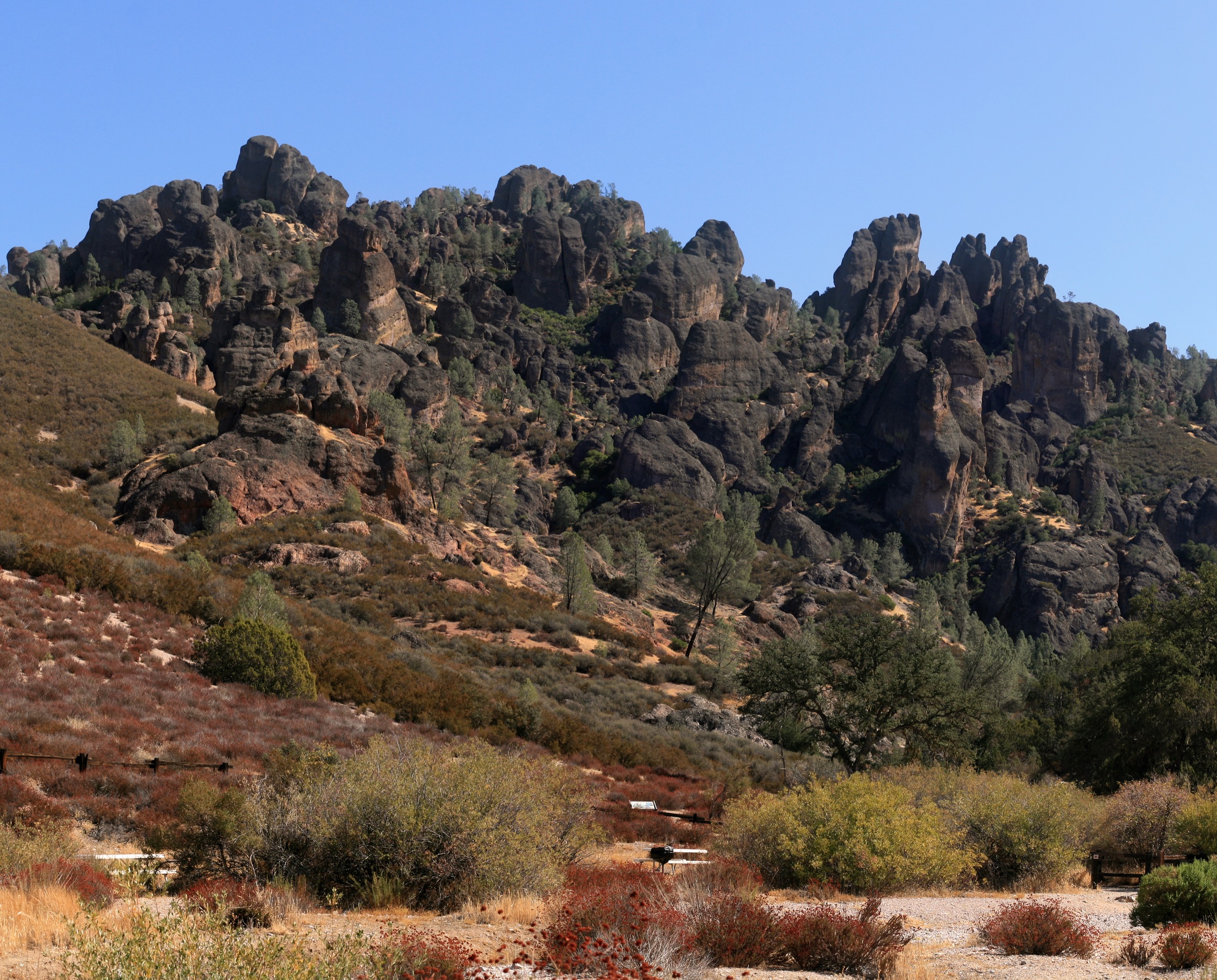
From the Bear Gulch Day Use Area the route climbs the Condor Gulch Trail north-west, gaining height through chaparral with framed views back across the reservoir. At the Condor Gulch overlook the trail continues to a junction with the High Peaks Trail, which is followed south along the volcanic spine of the park through the “Steep and Narrow” section — a series of steps and handrail-assisted passages carved directly into the tuff by the Civilian Conservation Corps in the 1930s. The route crosses the highest point on the ridge at approximately 792 m before dropping steeply south to the Bear Gulch area, closing the loop past the reservoir and the Bear Gulch Cave (seasonally closed). AllTrails records a 9.7 km loop with roughly 400 m of gain. Variants adding the Rim Trail past the reservoir extend the loop to 11–12 km.
Why it is essential
The High Peaks are the defining landscape of Pinnacles National Park and one of the most distinctive volcanic terrains in California, the eroded remnants of the 23-million-year-old Neenach Volcano displaced roughly 315 km north-west along the San Andreas Fault. The rock-cut steel-railing sections are unlike anything else on this list, and the ridge is one of the most reliable observation posts for reintroduced California condors on the central coast.
Equipment
Sturdy hiking shoes with good traction for the polished rock steps, 2–3 L water (no reliable sources on the loop), sun hat and high-SPF sun protection, wind layer for the ridge, and a headlamp only if extending into Bear Gulch Cave when open. Trekking poles are useful on the descent but hinder the handrail sections.
Hazards and notes
Sun and heat exposure on the ridge are the primary risks; NPS advises against summer afternoon travel and posts heat warnings. The Steep and Narrow section has short vertical drops and fixed handrails but no fall protection — parties with young children or vertigo should choose the Tunnel Trail bypass. Rattlesnakes are active March–October. Drones are prohibited. Dogs are not permitted on any trail inside Pinnacles.
GPX / route file
| Source | URL | Format / access | Reuse status |
|---|---|---|---|
| National Park Service — Trails of Pinnacles | nps.gov | Official trail page and downloadable map PDF | Public-domain federal agency material; no GPX published |
| AllTrails — High Peaks and Bear Gulch Loop | alltrails.com | Source map / downloadable GPX via AllTrails account | AllTrails terms apply; direct GPX not retrieved |
Further reading
- National Park Service — Pinnacles: Trails
- National Park Service — Condors at Pinnacles
- AllTrails — High Peaks and Bear Gulch Loop
2. Balconies Cliffs and Balconies Cave Loop
Snapshot
Itinerary
From the Chaparral Trailhead the Balconies Trail runs north-east along the West Fork Chalone Creek to a signed junction. The loop is normally walked anticlockwise: the Balconies Cliffs Trail climbs onto a rocky bench with direct views of Machete Ridge and the Balconies formation, then drops back to the main trail. The return leg passes through the Balconies Cave, a talus corridor formed by house-sized boulders wedged between the walls of a narrow slot — a headlamp is required, and there is low-scale scrambling over boulders and short drops. NPS lists the full loop at 2.4 miles (3.9 km) with roughly 200 ft (60 m) of elevation change. Reversing the loop through the cave first is also common.
Why it is essential
Balconies Cave is one of only two developed talus caves in the park (the other being Bear Gulch) and the only one on the west side, giving the west entrance its signature short walk. It provides an approachable contrast to the High Peaks ridge, uses a completely different trailhead, and is short enough to combine with the High Peaks Loop on a two-day visit or to swap in when heat or family composition rules out the summit ridge.
Equipment
Hiking shoes with grip, headlamp (mandatory in the cave), sun protection for the exposed cliff section, and 1–1.5 L water. A light jacket is useful in the cave, which is noticeably cool year-round.
Hazards and notes
The cave is closed seasonally to protect a colony of Townsend’s big-eared bats — check the current NPS status before travel. The cave also closes after heavy rain when the passage floods. Low ceilings and uneven boulder floors demand steady balance. Dogs are not permitted. Rattlesnakes are active in the approach corridor March–October.
GPX / route file
| Source | URL | Format / access | Reuse status |
|---|---|---|---|
| National Park Service — Balconies Cliffs to Balconies Cave | nps.gov | Official trail description | Public-domain federal agency material; no GPX published |
| AllTrails — Balconies Cave Trail | alltrails.com | Source map / downloadable GPX via AllTrails account | AllTrails terms apply; direct GPX not retrieved |
Further reading
- National Park Service — Balconies Cliffs to Balconies Cave
- National Park Service — Cave Status
- AllTrails — Balconies Cave Trail
3. Fremont Peak summit
Snapshot
Itinerary
From the upper parking area the trail follows a short, mostly gravel and dirt path south-west across grassland and blue-oak savanna. Most of the elevation to Fremont Peak is absorbed by the paved park road, leaving roughly 300 ft (90 m) of vertical for the walking portion. The final approach to the summit is a rocky scramble up a jumbled granite and marble outcrop; hands are needed for the last few metres. From the top the view spans Monterey Bay to the west, the Salinas Valley below, the Santa Lucia crest across the valley, the Diablo Range to the east and — on a clear day — the Sierra Nevada. The Valley View Loop returning by the eastern slope adds a modest addition to the direct out-and-back.
Why it is essential
Fremont Peak is the highest and northernmost signature summit of the Gabilan Range, and the site of John C. Frémont’s 1846 stand against Mexican authorities — the flag-raising that helped precipitate the Bear Flag Revolt. It is by far the shortest route in this catalogue and the only true panorama summit of the northern inland Coast Ranges reachable in under two hours on foot.
Equipment
Standard walking shoes, sun protection, 1 L water, warm layer in winter (the summit is noticeably windier and cooler than the trailhead). Grip is more important than sole stiffness for the summit scramble.
Hazards and notes
The final scramble has low but real fall exposure over broken rock; take care with children and dogs (dogs are permitted on leash on the trail, but not on the summit block scrambling). Poison oak is present on the shaded lower slopes. The road up from San Juan Bautista is narrow, steep and prone to closure in fog and after storms.
GPX / route file
| Source | URL | Format / access | Reuse status |
|---|---|---|---|
| California State Parks — Fremont Peak State Park | parks.ca.gov | Official park page and downloadable brochure PDF | State agency material; no GPX published |
| AllTrails — Fremont Peak and Valley View Loop | alltrails.com | Source map / downloadable GPX via AllTrails account | AllTrails terms apply; direct GPX not retrieved |
Further reading
4. Manzana Creek to Manzana Narrows
Snapshot
Itinerary
The Manzana Trail (Forest Service #30W13) begins at Nira Campground at the end of Sunset Valley Road and follows the north bank of Manzana Creek upstream into the San Rafael Wilderness, California’s first Congressionally designated wilderness (1968). The trail crosses the creek repeatedly — commonly cited crossing counts run from a dozen to more than twenty depending on flow, alignment and post-fire deadfall detours — and passes Potrero, Coldwater and Lost Valley trail camps before entering a shaded sandstone gorge in the upper canyon. Manzana Narrows Camp, roughly 11 km from Nira, sits at the base of the narrows where deep pools and short chockstone barriers block casual progress. AllTrails and the Hike Los Padres project both list the full out-and-back at roughly 22–23 km with 400–500 m of cumulative gain.
Shorter day-hike turnarounds — Lost Valley Camp (approximately 1.8 km one-way), Potrero Camp or Fish Creek Camp — remain viable when time or water flow rules out the full narrows.
Why it is essential
The Manzana corridor is the classic day-hike introduction to the San Rafael Wilderness — a shaded, creek-driven canyon walk that samples the sandstone and chaparral character of the interior Los Padres without committing to a multi-day traverse toward Hurricane Deck or the Sisquoc. It is also the only route in this selection that sits inside a Congressionally designated wilderness area.
Equipment
Waterproof-friendly footwear or wading sandals for the crossings, 3 L water plus filter or chemical treatment (the creek itself is the water source), sun and heat protection, long trousers for chaparral scratch, a paper Los Padres map, and a headlamp for a shorter-than-expected day. Tick check on return is standard.
Hazards and notes
Access is the primary concern: Sunset Valley Road / FS 7N02 and the Happy Canyon approach have been repeatedly closed by Los Padres National Forest for fire and storm damage — confirm current status with the Santa Lucia Ranger District before driving. Post-Zaca and post-Rey fire vegetation regrowth has changed trail alignments in places. Ticks are heavy in spring; rattlesnakes are active March–October. The full narrows day is genuinely long and shade-thin above Lost Valley — start early. Wilderness fire restrictions and campfire permits apply beyond the trailhead.
GPX / route file
| Source | URL | Format / access | Reuse status |
|---|---|---|---|
| USDA Forest Service — Manzana Trail 30W13 | fs.usda.gov | Official trail page | Public-domain federal agency material; no GPX published |
| AllTrails — Manzana Trail Loop: Nira to Schoolhouse | alltrails.com | Source map / downloadable GPX via AllTrails account | AllTrails terms apply; direct GPX not retrieved |
| Hike Los Padres — Manzana Trail West | hikelospadres.com | Route description and mileage log | Site terms apply; reference only |
Further reading
- USDA Forest Service — Manzana Trail 30W13
- USDA Forest Service — Nira Campground
- Hike Los Padres — San Rafael Wilderness
- AllTrails — Manzana Trail Loop
5. Caliente Mountain via Caliente Ridge
Snapshot
Itinerary
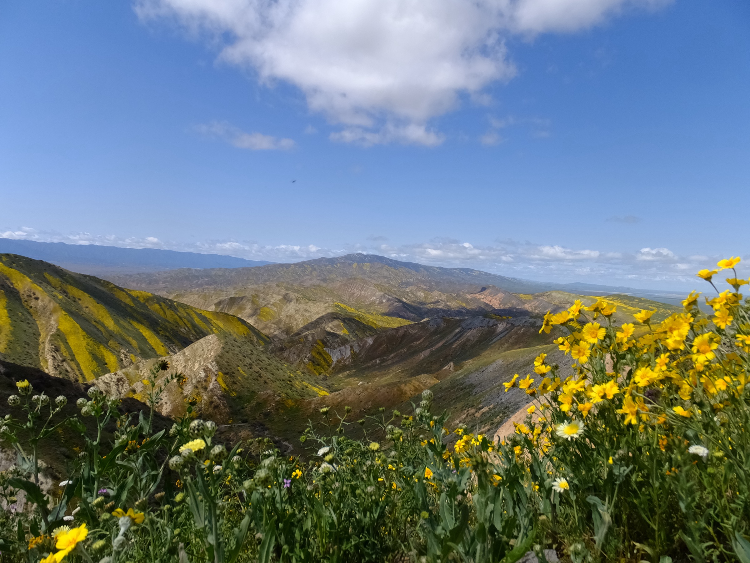
From the Selby trailhead a rough double-track climbs south-west onto the crest of the Caliente Range and then follows the open ridge for its full length toward Caliente Mountain, the highest point in San Luis Obispo County at 1,556 m. The Bureau of Land Management manages the route as the Caliente Mountain Ridge Trail; the AllTrails track logs 16.9 mi (27.0 km) round-trip with 735 m of gain, essentially without a switchback. The ridge holds views north over Soda Lake and the Carrizo Plain to the Temblor Range and the San Andreas Fault, and south over the Cuyama Valley to the Sierra Madre and San Rafael Mountains. The summit itself is unmarked apart from the collapsed timbers of a World War II aircraft observation post. Shorter turnarounds at the wilderness study area boundary (roughly 14 km round-trip) or an unnamed gated tower point (approximately 10.6 km round-trip) are the standard alternatives.
Why it is essential
Caliente Mountain is the highest and most remote summit in this catalogue, and the signature long-day walk of Carrizo Plain National Monument. It combines the largest single-day remnant of the interior Coast Range wildflower landscape with a genuinely wilderness-feel ridge — no water, no shade, no infrastructure — inside a nationally protected monument.
Equipment
Full desert day-hike kit: 4 L water minimum for the summit round-trip (no water on the ridge), sun hat and long sleeves, high-SPF sun protection, wind shell (the ridge is exposed), navigation backup, and sturdy trail shoes. Trekking poles help on the return. Charge devices before leaving the visitor centre — there is no cellular coverage on the ridge.
Hazards and notes
Heat and dehydration are the headline hazards. Californian condors are recovering across the Southern Coast Ranges and Carrizo Plain — do not disturb any bird found on or near the trail. Burrowing owl and pronghorn habitat protections apply on approach roads and adjacent grassland; stay on designated tracks. Road access from Soda Lake Road becomes impassable to standard cars after heavy winter rain; BLM regularly posts temporary closures. The Painted Rock cultural site nearby has separate access rules and seasonal closure. Rattlesnakes are active February–October.
GPX / route file
| Source | URL | Format / access | Reuse status |
|---|---|---|---|
| Bureau of Land Management — Carrizo Plain National Monument | blm.gov | Official monument page and map PDFs | Public-domain federal agency material; no GPX published |
| AllTrails — Caliente Mountain Ridge Trail | alltrails.com | Source map / downloadable GPX via AllTrails account | AllTrails terms apply; direct GPX not retrieved |
| CalWild — Caliente Mountain Ridge Trail | calwild.org | Advocacy trail description | Site terms apply; reference only |
Further reading
- Bureau of Land Management — Carrizo Plain National Monument
- CalWild — Caliente Mountain Ridge Trail
- AllTrails — Caliente Mountain Ridge Trail
Further reading
| Source | URL |
|---|---|
| National Park Service — Pinnacles National Park | nps.gov |
| National Park Service — Pinnacles Cave Status | nps.gov |
| California State Parks — Fremont Peak State Park | parks.ca.gov |
| California State Parks — Henry W. Coe State Park | parks.ca.gov |
| USDA Forest Service — Los Padres National Forest | fs.usda.gov |
| USDA Forest Service — San Rafael Wilderness | fs.usda.gov |
| Bureau of Land Management — Carrizo Plain National Monument | blm.gov |
| Wikimedia Commons — Category: Pinnacles National Park | commons.wikimedia.org |
| Wikimedia Commons — Category: Carrizo Plain National Monument | commons.wikimedia.org |
| Wikipedia — California Coast Ranges | en.wikipedia.org |