Regional overview
The Wet Tropics of Queensland World Heritage Area runs 450 km along the northeast Australian coast between Cooktown and Townsville, protecting one of the oldest continuously forested landscapes on Earth. The Great Dividing Range rises steeply from the Coral Sea to a fringe of coastal-plain ridges and mid-elevation escarpments — the Daintree ranges to the north, Barron Gorge and the Lamb Range behind Cairns, the Bellenden Ker Range further south, and finally the Seaview and Paluma Ranges at the southern end. These coastal mountains carry the wettest rainforest on the continent — annual rainfall exceeds 8,000 mm on Bellenden Ker — and support an extraordinary concentration of relictual Gondwanan plant families that are found nowhere else in Australia. The area is inscribed on the World Heritage List for its outstanding natural values and is co-managed by Queensland Parks and Wildlife Service (QPWS) with the Wet Tropics Management Authority and Traditional Owner groups.
The Traditional Owners of the coastal Wet Tropics number more than twenty language groups. The Eastern Kuku Yalanji hold Country through the Daintree and Mossman Gorge; the Djabugay hold the Kuranda and Barron Gorge corridor (Buda-dji is the ancestral being who shaped the river); the Mamu, Ma:Mu, Ngadjon-Jii and Yidinji groups share the ranges behind Innisfail and the Bellenden Ker escarpment; the Warrgamay and neighbouring nine Girringun groups hold the Cardwell and Wallaman country; and the Nywaigi hold the coastal plain around Ingham where the Paluma Range meets the sea. Ngadjon-Jii oral history preserves detailed memory of Holocene volcanism on the plateau, and Kuku Yalanji, Djabugay and Nywaigi place-names are used consistently on modern QPWS interpretation.
The reliable walking season is May to October: cool mornings, low humidity and firm tread. November to April brings the tropical wet, cyclone risk, road washouts, high leech and tick loads and dangerous flash flooding in the escarpment gorges. Marine stingers (box jellyfish and Irukandji) make open-beach swimming inadvisable November to May. Estuarine (saltwater) crocodiles are present in every coastal river below the escarpment, including the lower Mossman and lower Barron; only signposted freshwater pools should be considered for swimming. The principal walking gateways are Cairns for the Daintree, Kuranda and Bellenden Ker approaches; Ingham for Wallaman Falls; and Townsville for the Paluma Range. There is no scheduled public transport to any of the trailheads listed below — a hire vehicle or organised tour is required.
Selection rationale
The five walks are chosen to cover the length and ecological range of the coastal Wet Tropics without duplicating the Atherton Tablelands catalogue (Lake Eacham, Mount Hypipamee, Millaa Millaa, Nandroya and Mount Bartle Frere are covered separately). Mossman Gorge and Mount Sorrow together represent the Daintree — a signature short rainforest circuit and the only serious summit day-hike in the coastal Daintree. The Douglas Track in Barron Gorge covers the historic Djabugay corridor between Kuranda and Kamerunga and gives the article a genuine ridge and river-terrace route. The Djyinda walk at Wallaman Falls includes Australia’s tallest single-drop waterfall and is the definitive Girringun escarpment descent. Jourama Falls anchors the southern end of the guide in the Paluma Range. Between the five, the article covers rainforest circuit, ridge summit, gorge traverse, waterfall descent and cascade walk — the coastal Wet Tropics’ five signature walking experiences.
Summary table
| # | Hike | Country | Route type | Distance | Gain | Max elevation | Difficulty |
|---|---|---|---|---|---|---|---|
| 1 | Mossman Gorge Rainforest Circuit | Australia | Loop | ~2.4 km | ~130 m | ~175 m | Grade 3 (QPWS) |
| 2 | Mount Sorrow Ridge Trail | Australia | Out-and-back | ~7.0 km | ~680 m | ~680 m | Grade 4 (QPWS) |
| 3 | Douglas Track and Din Din / Barron Falls | Australia | Point-to-point or out-and-back | ~10–12 km | ~350 m | ~400 m | Grade 4 (QPWS) |
| 4 | Djyinda Walk to Wallaman Falls base | Australia | Out-and-back | ~3.2 km | ~270 m | ~570 m | Grade 4 (QPWS) |
| 5 | Jourama Falls Lookout Walk | Australia | Out-and-back | ~3.0 km | ~110 m | ~130 m | Grade 3 (QPWS) |
1. Mossman Gorge Rainforest Circuit
Snapshot
Itinerary
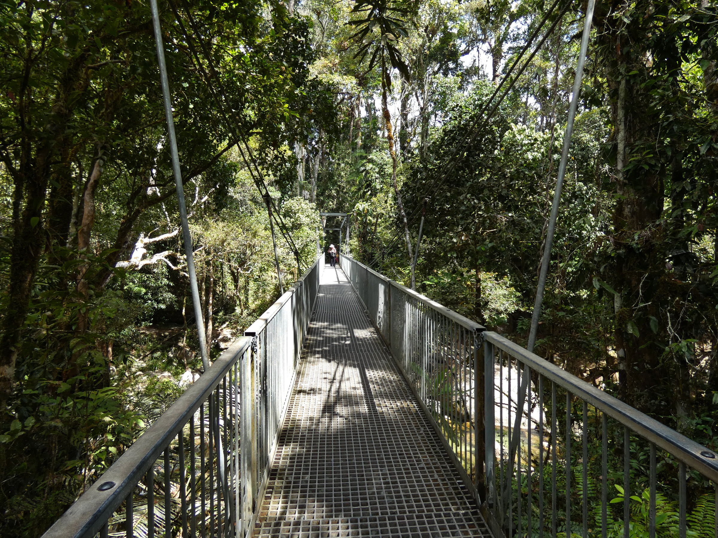
The Mossman Gorge Centre operates a compulsory shuttle bus from the visitor centre to the Rex Creek trailhead, 2 km up-valley. From the trailhead the Rainforest Circuit crosses the Rex Creek suspension footbridge — a photogenic steel-cable span above a boulder-strewn rainforest creek — and enters mature lowland complex mesophyll vine forest with strangler figs, buttress-rooted trees and heavy epiphyte load. The circuit climbs a short rise onto a ridge terrace above the Mossman River, following a formed track with steps and interpretive signage on Kuku Yalanji plant use and rainforest ecology. Signposted spurs descend to viewpoints over Rex Creek and Wurrmbu Creek before the circuit rejoins the shuttle turnaround. Swimming is permitted from the fenced signed pool below the suspension bridge in the dry season only.
Why it is essential
Mossman Gorge is the most accessible signature rainforest walk in the coastal Wet Tropics and the gateway to Eastern Kuku Yalanji Country. The Rex Creek suspension bridge is one of the most-photographed images of the Daintree, and the circuit gives a compact ecological survey of lowland mesophyll rainforest that sets up every other walk in this article.
Equipment
- Trail runners or light walking shoes
- Swimwear and quick-dry towel (dry season only)
- Insect repellent
- Rain shell
- 1 L water
- Small pack — the shuttle-return format keeps kit light
Hazards and notes
- Estuarine crocodiles inhabit the lower Mossman River; swim only from the signed pool inside the gorge.
- Flash flooding on Rex and Wurrmbu Creeks after heavy rain — the suspension bridge and lower pools can become unsafe within an hour.
- Boardwalks and basalt boulders are slippery when wet.
- Cassowaries occasionally cross the track; give right of way and do not approach.
- Leeches heavy November to April.
- Rex Creek suspension bridge and Rainforest Circuit have been subject to QPWS closures for engineering works — verify status via park alerts before travel.
GPX / route file
| Source | URL | Format | Notes |
|---|---|---|---|
| QPWS — Rainforest Circuit Track, Mossman Gorge | parks.qld.gov.au | Web page | Official route source; Mossman Gorge map PDF |
| QPWS — Park alerts | parks.qld.gov.au | Web page | Check current bridge / circuit status |
Sources
- QPWS Daintree National Park — Rainforest Circuit Track
- Wikimedia Commons — Mossman Gorge suspension bridge
- Wikipedia — Eastern Kuku Yalanji
2. Mount Sorrow Ridge Trail
Snapshot
Itinerary
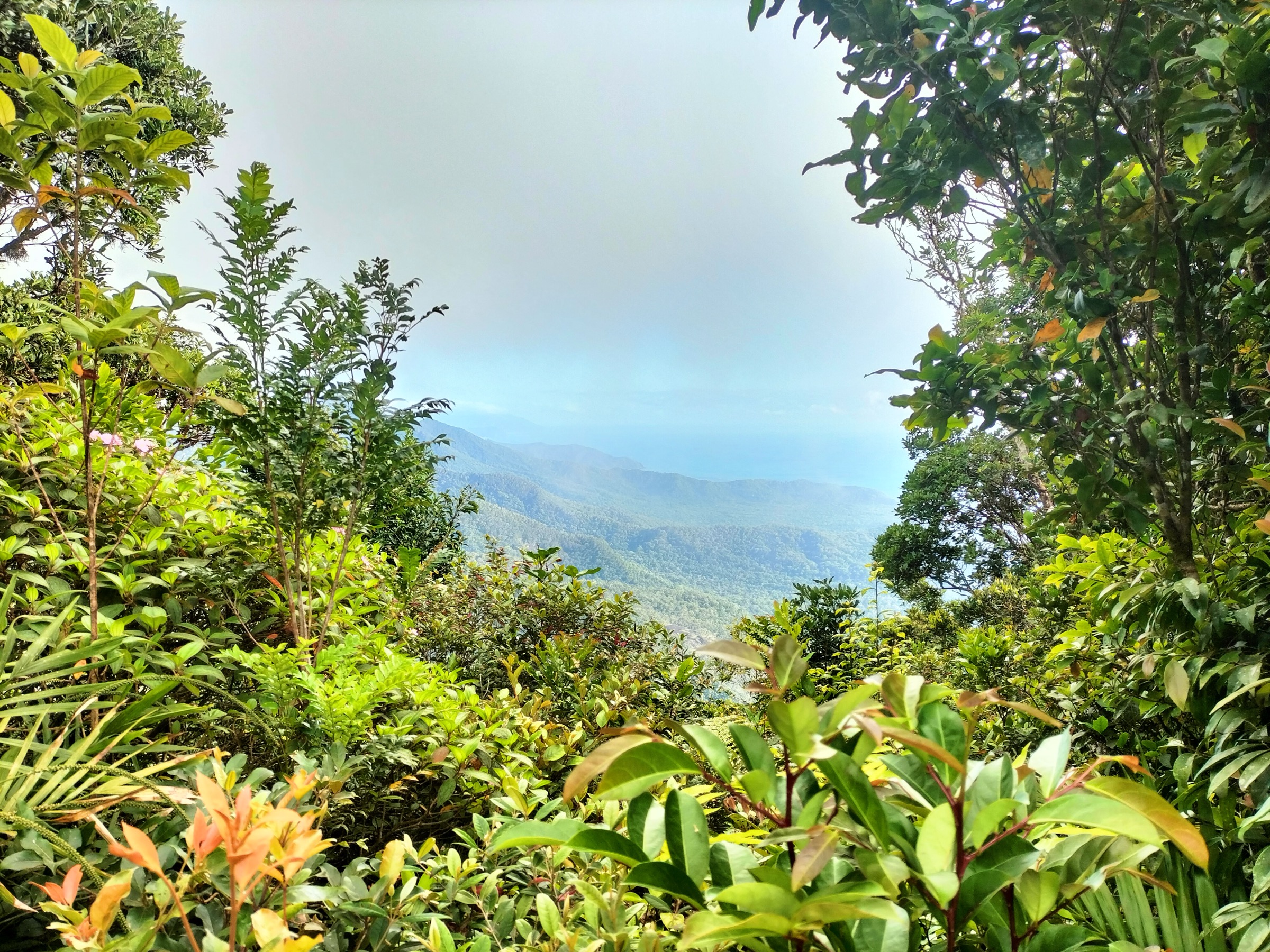
The Mount Sorrow trailhead is a signposted forestry gate on the western side of Cape Tribulation Road, 150 m north of the Kulki day-use area. Walkers must sign the trailhead register and are required to be off the ridge by 4 pm. The route enters lowland complex mesophyll vine forest and climbs steeply on a rooted, muddy tread with occasional fixed ropes at the steepest sections. The gradient eases briefly on a mid-slope terrace at approximately 400 m before resuming a hard climb through progressively drier ridge forest with piccabeen palms and cutting grass. The ridge lookout at approximately 680 m is a small clearing on a rock ledge with panoramic views (weather permitting) over Kulki, Myall Beach, Snapper Island and the mouth of the Daintree River. Return is on the same line — descent is knee-punishing and typically slower than the ascent because the tread is slippery on the fixed-rope sections.
Why it is essential
Mount Sorrow is the only serious summit day-hike in the coastal Daintree and the definitive strenuous route north of the Cairns range. It puts a fit party on top of the coastal escarpment above the world’s most iconic rainforest-meets-reef view and gives the article a genuine mountain contrast to the boardwalk-based Daintree tourism experience.
Equipment
- Sturdy boots with good grip (muddy tread and fixed ropes)
- Trekking poles strongly recommended
- 2.5–3 L water — no reliable source on the ridge
- Long sleeves and long pants (stinging tree, cutting grass, leeches)
- Gaiters
- Headtorch with spare batteries — the 4 pm off-ridge rule means late starts are risky
- Personal Locator Beacon (PLB) or satellite messenger
- Rain shell
- First-aid kit including snake-bite bandage
Hazards and notes
- Grade 4 (QPWS class this as a “remote” walk); QPWS requires trailhead register sign-in and requires walkers to be off the ridge by 4 pm.
- Stinging tree (Dendrocnide moroides) grows across the track — do not brush broad-leaved shrubs.
- Fixed-rope sections are slippery when wet; abrasive on hands.
- Cassowaries at trailhead; give right of way.
- No phone signal on the ridge.
- Cape Tribulation Road access closed periodically after cyclones — verify status via park alerts before travel.
- Estuarine crocodiles inhabit the lower Cooper Creek and lower Daintree River — no swimming from access beaches without local advice.
GPX / route file
| Source | URL | Format | Notes |
|---|---|---|---|
| QPWS — Mount Sorrow ridge trail | parks.qld.gov.au | Web page | Official route source |
| QPWS — Park alerts | parks.qld.gov.au | Web page | Check road and track status |
Sources
- QPWS Daintree National Park — Mount Sorrow ridge trail
- Wikimedia Commons — Mount Sorrow
- Wikipedia — Cape Tribulation
3. Douglas Track and Din Din / Barron Falls
Snapshot
Itinerary
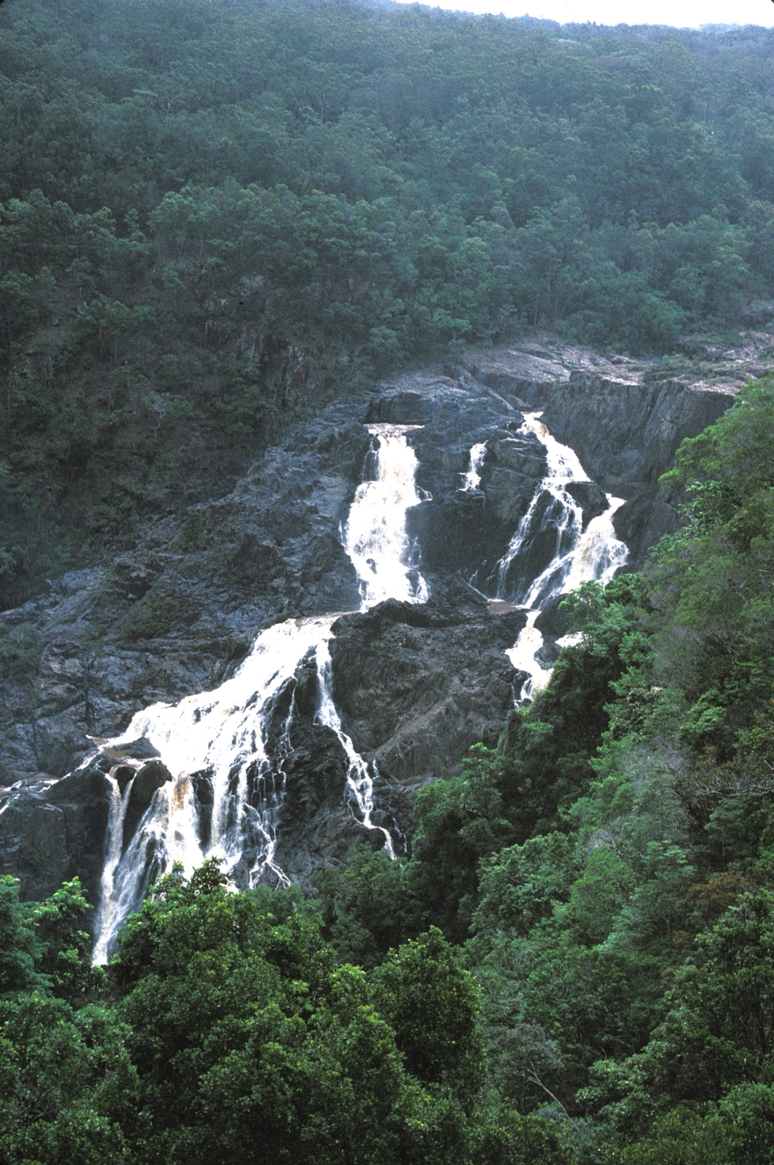
The Douglas Track is the historic 19th-century goldfields packhorse route between Cairns and the Herberton tin fields via Kuranda. The upper trailhead at Speewah sits on the ridge above Kuranda; the lower trailhead at Kamerunga sits on the coastal plain at the mouth of Barron Gorge. From the Speewah trailhead the route drops through open eucalypt forest and rainforest transition on a formed but steep track, passing McDonald Track junction and the Wrights Lookout viewpoint before continuing down to Glacier Rock — a granite slab lookout above the gorge with views to Barron Falls. Below Glacier Rock the track continues down through progressively lower and drier forest to Kamerunga on the coastal plain. A separate short walk (1.2 km, Grade 1) from the Din Din / Barron Falls car park at Kuranda gives the classic tiered-cascade viewpoint above the falls; this can be combined with the Douglas Track using the Kuranda Scenic Railway or Skyrail for the return leg.
Why it is essential
The Douglas Track is the definitive Djabugay-country walk on the escarpment behind Cairns and the historic route between the coast and the tablelands. The Barron Falls lookout add-on gives the walk the region’s most-photographed waterfall view. Together the two form the article’s classic gorge and ridge combination.
Equipment
- Sturdy walking shoes with grip
- Trekking poles for the steep descent
- 2 L water
- Rain shell
- Insect repellent
- Sun protection (open forest sections)
- First-aid kit
- Coins / cards for Kuranda Scenic Railway or Skyrail if using them for return
Hazards and notes
- Steep drops off the Glacier Rock and Barron Falls lookout edges — keep to fenced viewing platforms.
- Tread is slippery when wet, especially on the granite slab sections.
- Leech and tick burden through the wet season.
- Occasional washouts on the Douglas Track after cyclones — verify status via park alerts.
- Estuarine crocodiles in the lower Barron River — no swimming below the gorge.
- Falls flow greatly reduced August to November when the Tinaroo hydro scheme diverts most of the Barron River.
GPX / route file
| Source | URL | Format | Notes |
|---|---|---|---|
| QPWS — Douglas Track from Kamerunga to Speewah | parks.qld.gov.au | Web page | Official route source |
| QPWS — Din Din / Barron Falls lookout track | parks.qld.gov.au | Web page | Official route source for the short add-on |
Sources
- QPWS Barron Gorge National Park — Douglas Track
- QPWS Barron Gorge National Park — Din Din / Barron Falls lookout
- Wikimedia Commons — Barron Falls National Park
- Wikipedia — Djabugay
4. Djyinda Walk to Wallaman Falls base
Snapshot
Itinerary
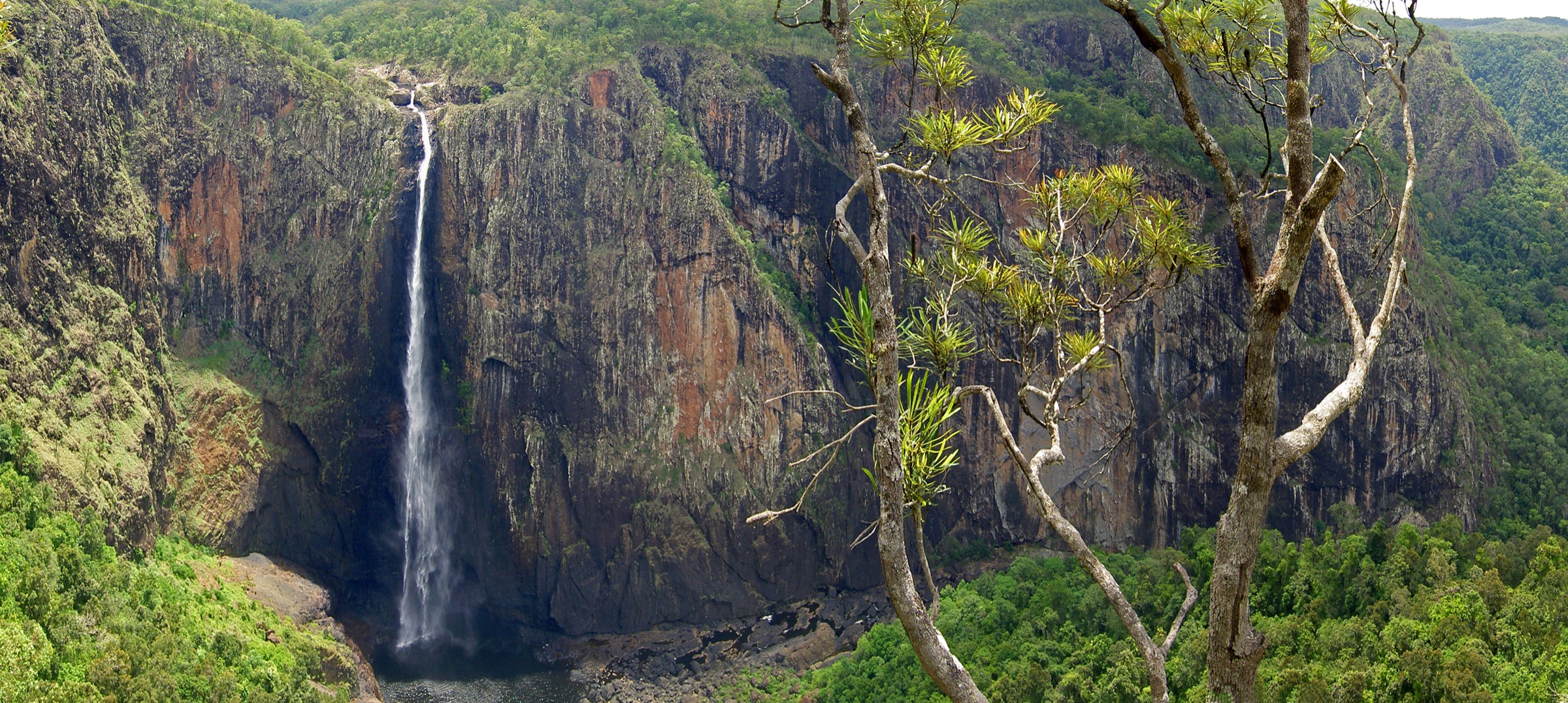
The Wallaman Falls lookout car park sits on the rim of Stony Creek gorge, with a fenced viewing platform giving the classic full-height view of the fall — a single free-drop plunge of 268 m, the tallest permanent single-drop waterfall in Australia. The Djyinda track leaves the eastern end of the car park and descends steeply on a well-formed switchbacked path through the wet sclerophyll to rainforest transition typical of the Seaview escarpment. The track crosses a small tributary before reaching a signed viewpoint above the plunge pool, then continues on rougher tread through the persistent mist zone at the base of the fall to the plunge pool itself, where the ambient noise and windblown spray give a strong sense of the fall’s scale. Return is on the same line — the ascent is the hard part of the day and takes at least half again as long as the descent.
Why it is essential
Wallaman Falls is Australia’s tallest single-drop waterfall and the definitive scenic set-piece of the southern Wet Tropics. The Djyinda walk is the only foot access from the lookout to the plunge pool and puts walkers inside the mist zone of the fall — a physical understanding of scale that the lookout view cannot supply.
Equipment
- Sturdy walking shoes with good grip
- Rain shell (persistent spray near the base)
- Dry-bag for camera and valuables
- 1.5 L water
- Insect repellent
- Trekking poles for the ascent
- First-aid kit
Hazards and notes
- Steep, slippery return climb — pace conservatively.
- Falling rocks and tree limbs from the escarpment above the plunge pool; do not linger directly under overhanging cliffs.
- Persistent mist zone soaks clothes and gear within minutes.
- Leech burden through the wet season; tick load year-round.
- Snakes in leaf litter — the walk is on the drier side of the wet-tropics range.
- Wallaman Falls camping area was closed for redevelopment from late 2025 into 2026; the lookout and Djyinda day walk itself remain open — verify status via park alerts before travel.
- Wet Tropics Great Walk sections that connect Wallaman to Paluma and Blencoe were scheduled for closure through 2026 for maintenance; the Djyinda day walk is unaffected.
GPX / route file
| Source | URL | Format | Notes |
|---|---|---|---|
| QPWS — Djyinda walk, Wallaman Falls | parks.qld.gov.au | Web page | Official route source |
| QPWS — Park alerts | parks.qld.gov.au | Web page | Check current alert status |
Sources
- QPWS Girringun National Park — Djyinda walk
- Wikimedia Commons — Wallaman Falls panorama
- Wikipedia — Wallaman Falls
5. Jourama Falls Lookout Walk
Snapshot
Itinerary
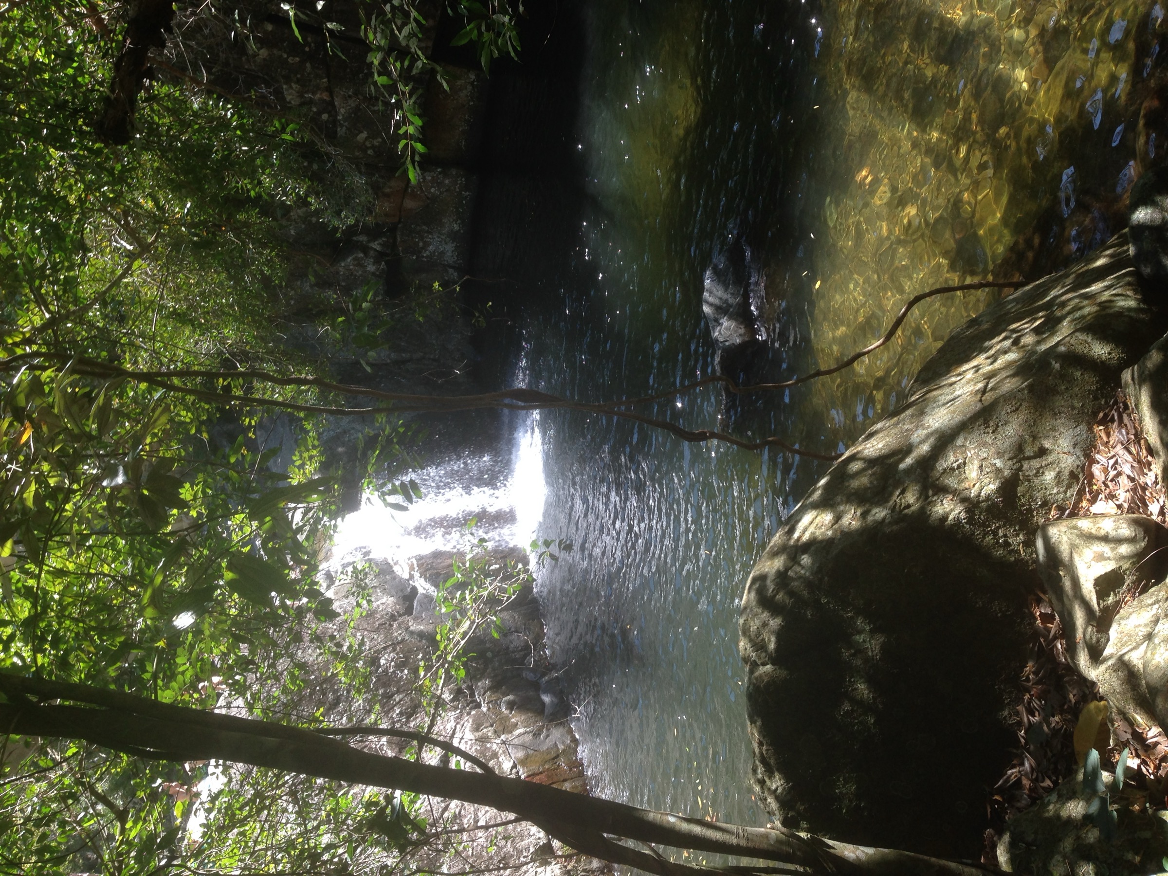
The Jourama Falls day-use area sits at the base of the Paluma Range in an open eucalypt clearing on Waterview Creek. The lookout walk leaves the car park along a formed path, crosses Waterview Creek on a rock-hop that becomes a wade after rain, and climbs through the transitional open forest and rainforest edge on a series of formed steps. The path passes a first lookout with a filtered view of the lower cascade before continuing up to a second, higher lookout that gives the classic angled view of Jourama Falls — a multi-tier cascade over pink granite boulders with clear rainforest pools on the intermediate benches. The site is known for mahogany glider habitat in the surrounding open forest and is culturally significant to the Nywaigi as Munan Gumburu, “misty mountain”. Return is on the same line.
Why it is essential
Jourama Falls anchors the southern end of the Wet Tropics guide. It gives the article a Paluma Range walk with a distinctly different character to the northern rainforest tracks — pink granite geology, open eucalypt fringe, mahogany glider habitat — and it is compact enough to combine with Wallaman Falls into a two-fall day on the drive between Ingham and Townsville.
Equipment
- Sturdy walking shoes with grip
- Rain shell
- Sun protection (open forest sections)
- 1.5 L water
- Insect repellent
- Swimwear and quick-dry towel if the lower pools are safe
Hazards and notes
- Rock-hop creek crossing can become dangerous or impassable after rain — turn back if the water is above knee height or discoloured.
- Slippery granite steps in wet weather.
- Snakes in leaf litter — the open-forest sections are hot in mid-morning.
- Estuarine crocodile sightings in the lower Waterview Creek are rare but not unknown; do not swim below the falls.
- Access road unsealed on the final section and floods in the wet.
- Paluma Range planned burns typically occur June to October — verify status via park alerts before travel.
GPX / route file
| Source | URL | Format | Notes |
|---|---|---|---|
| QPWS — Jourama Falls lookout walk | parks.qld.gov.au | Web page | Official route source |
| QPWS — Park alerts | parks.qld.gov.au | Web page | Check road and burn schedule |
Sources
- QPWS Paluma Range National Park — Jourama Falls lookout walk
- Wikimedia Commons — Jourama Falls
- Wikipedia — Paluma Range National Park
Region-level sources
| Source | URL |
|---|---|
| QPWS Daintree National Park | parks.qld.gov.au |
| QPWS Barron Gorge National Park | parks.qld.gov.au |
| QPWS Girringun National Park (Wallaman) | parks.qld.gov.au |
| QPWS Paluma Range National Park | parks.qld.gov.au |
| QPWS park alerts | parks.qld.gov.au |
| Wet Tropics Management Authority | wettropics.gov.au |
| Wikipedia — Wet Tropics of Queensland | en.wikipedia.org |
| Wikipedia — Daintree National Park | en.wikipedia.org |
| Wikipedia — Wallaman Falls | en.wikipedia.org |
Further reading
Nearby Great Dividing Range guides on Storm
- ACT, Namadgi and the Brindabella Ranges
- Atherton Tablelands / Cairns Highlands
- Barrington Tops
- Blue Mountains
- Wikipedia — Kuku Yalanji
- Wikipedia — Djabugay
- Wikipedia — Nywaigi
Missing data / follow-up work
- QPWS does not publish direct GPX or KML downloads for any of the walks listed above. All route files are official web-page or PDF sources.
- Precise trailhead coordinates for Mossman Gorge, Kulki, Speewah, Kamerunga, Wallaman and Jourama are shown only on QPWS short-walk PDF maps; extract before publishing a machine-readable route database.
- Rex Creek suspension bridge and the Mossman Gorge Rainforest Circuit have been subject to closures for engineering works — confirm current status via park alerts before travel.
- Cape Tribulation Road access is periodically closed after cyclones; the Bloomfield Track north of Cape Tribulation is 4WD-only and unrelated to the Mount Sorrow trailhead.
- Wallaman Falls camping area redevelopment and Wet Tropics Great Walk maintenance closures through 2026 do not affect the Djyinda day walk itself, but the wider trail network is disrupted.
- Barron Falls flow is greatly reduced August to November due to the Tinaroo hydro diversion; the walk is worth doing in this window for the geology but the fall itself is a trickle.