Regional overview
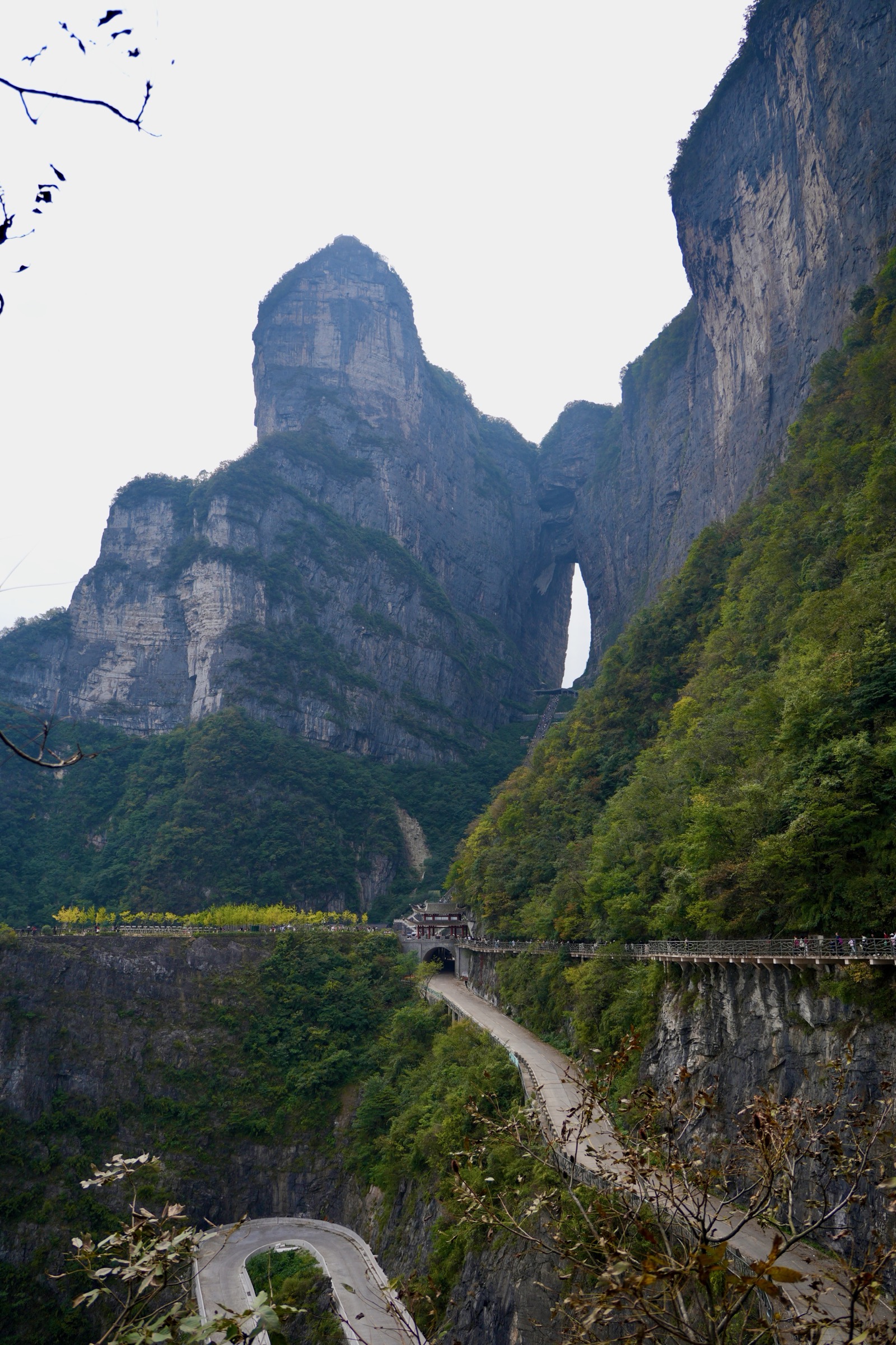
Tianmen Mountain (天门山, “Heavenly Gate Mountain”) rises 1,518.6 m directly above Zhangjiajie city in the western Hunan section of the Wuling Mountains, the sandstone-and-limestone range that defines the boundary between the Yangtze plain and the dissected karst uplands of Guizhou and Chongqing. Geologically Tianmen is a remnant Triassic-to-Permian carbonate massif capped by a quartzite cuesta, isolated from the surrounding Wuling sandstone-pillar country by deep limestone gorges; structurally it belongs to the Yangtze block south margin and shares fold-and-thrust geometry with the wider Wuling range, but its dominant rock type — soluble carbonates rather than the orthoquartzites of the neighbouring Zhangjiajie / Wulingyuan sandstone-pillar landscape — gives it a karst summit plateau, a perforating natural arch and a system of through-caves that the Wulingyuan UNESCO core, 30 km north, does not possess. The mountain’s defining feature, Tianmen Cave (天门洞, “Heaven’s Gate”), is a 131.5 m high, 57 m wide and roughly 60 m deep collapse-arch through the south face of the summit ridge — the highest naturally formed mountain arch in the world by recorded vertical clearance — created when, according to the Records of the Yongding Garrison, a section of the south wall collapsed catastrophically in 263 CE during the Three Kingdoms period and opened the cave-window that has framed the south horizon ever since.
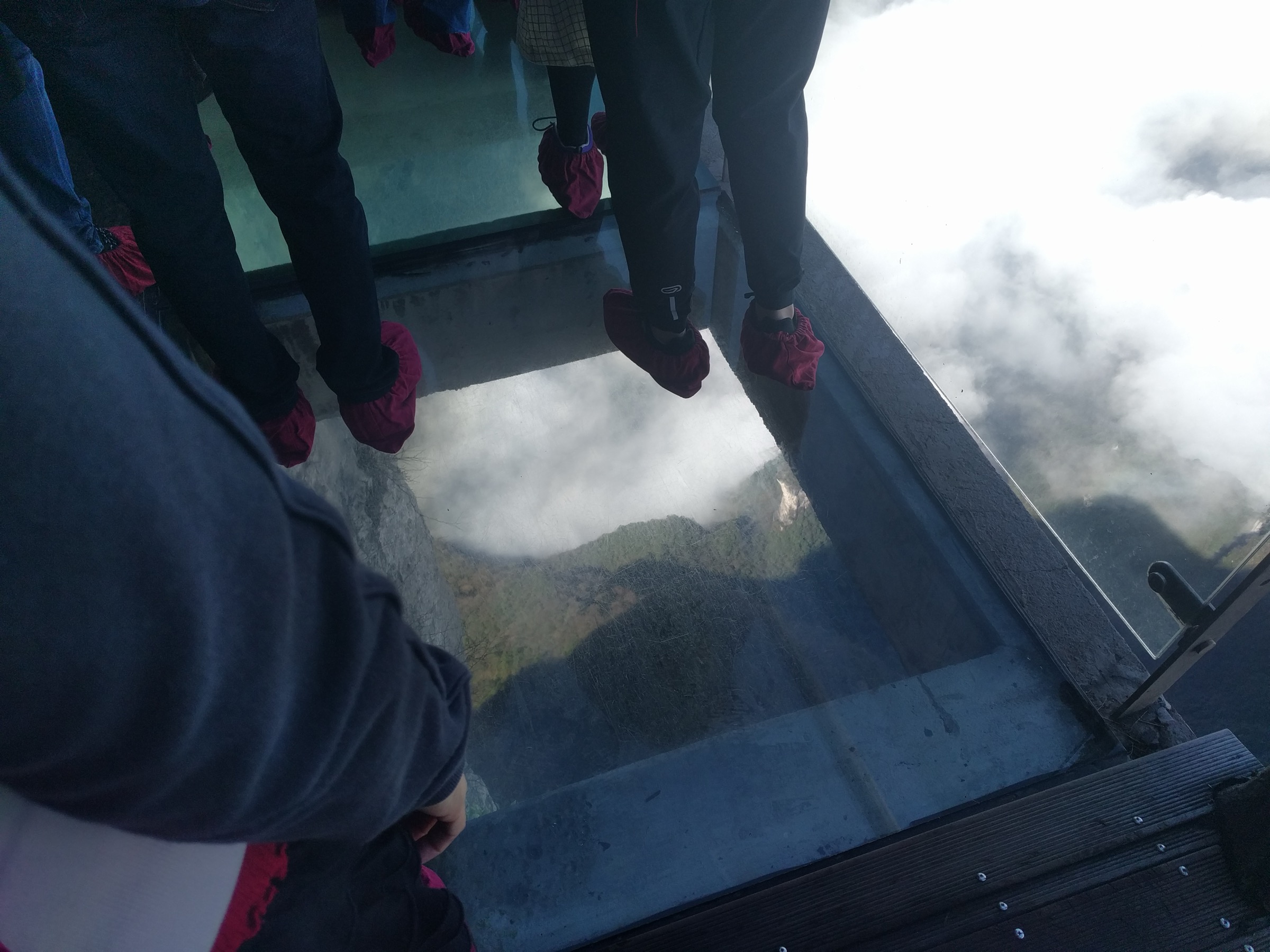
Tianmen Mountain National Forest Park (天门山国家森林公园) was declared in 1992 from the existing scenic-area boundary, raised to AAAAA (Class 5A) status by the China National Tourism Administration, and developed in the early 2000s into one of the most intensively engineered mountain visitor sites in China. The Tianmen Mountain Cableway, opened 30 September 2005 and built by Pomagalski of Voreppe, France, is one of the longest single-cable passenger cableways in the world at 7,455 m horizontal length and 1,279 m vertical rise; it runs almost continuously from the lower station at Zhangjiajie railway plaza to the summit platform in roughly 28 minutes. The road approach below the cliffs — Tongtian Avenue (通天大道, “Avenue Toward Heaven”), opened in 2006 — climbs from 200 m to 1,300 m in 11 km across 99 numbered hairpins, a feature later made internationally familiar by the annual Red Bull street-climb events. Above the cave, a 999-step stone staircase — the “Sky Ladder” — climbs through the arch directly to the lower summit platform; from there a network of cliff-edge balcony paths, glass walkways and forest tracks loops the upper plateau and links to the Tianmen Temple (天门寺) at around 1,400 m and the Yunmeng Xianding (云梦仙顶, “Cloud-Dream Immortal Summit”) viewing area at the 1,518.6 m high point. The cliff-path network totals approximately 7.5 km of cantilever wooden boards and inset stone steps; three named glass-floor sections (Coiling Dragon Cliff, 2016; East-Line Glass Walkway, 2011; and the West-Line glass platform) project beyond the rock face.
Walking on Tianmen is engineered scenic-area walking rather than wilderness hiking. A normal visit combines the cableway, paid park shuttle, escalator system, cliff paths and stair sections under one ticket; private vehicles cannot reach the upper trail-heads. The currently published combined ticket runs around 278 RMB and is routed by visitor-control letters: Line A starts with the cableway up and descends by escalator + shuttle, Line B does the reverse, and Line C uses a one-way express cableway during peak crowd-control mode — the lettered routing is decided each morning by the park authority and changes the practical sequence of the five walks below. Subtropical western-Hunan weather, not altitude, is the operational constraint: July–August convective storms can suspend cableway operation and close the glass walkways for hours at a time, summer crowding regularly produces multi-hour queues on the 999-step stair and the East-Line glass walkway, and winter ice on the upper plateau can close the cliff paths between mid-December and early February. The cleanest walking windows are mid-March to early June and mid-September to mid-November; avoid the 1 May and 1 October Golden Weeks unless queue tolerance is high.
Access is straightforward by rail and air. Zhangjiajie West HSR station (opened 2021) connects to Changsha in around 1 h 30, Wuhan in 4 h and Guangzhou in 6 h; the older Zhangjiajie station holds the lower cableway terminal directly above its forecourt. Zhangjiajie Hehua International Airport is 5 km south of the city. The wider Wuling range — including the sandstone-pillar landscape of Wulingyuan / Zhangjiajie National Forest Park 35 km north, and the Furong-Dehang karst country to the south-west — is the natural multi-day pairing for a Tianmen day; the two landscapes are 1–1.5 hours apart by road and answer different parts of the Wuling story.
Selection rationale
The five walks below cover the practical hiking character of Tianmen Mountain without pretending it is a backcountry range. Because the summit network is compact and the cableway / shuttle / escalator system funnels everyone through the same gates, the entries are best read as the five essential walking circuits and spurs that together make up a complete Tianmen Mountain day — not as five independent day-hikes. The full assisted circuit is the first entry for walkers who want to do everything in one go; the West Line and East Line are the two paired cliff-path components of that circuit and stand alone as half-day options; the 999-step Sky Ladder + Tianmen Cave is the iconic short objective; and the Tianmen Temple to Yunmeng Xianding spur is the cultural and high-point conclusion. A Tianmen day that does all five comes to roughly 14–16 km on foot inside a 4–6 hour managed-park visit.
The much larger Wulingyuan / Zhangjiajie sandstone-pillar landscape 35 km north — which sits in a different protected property and a fundamentally different geology — is deliberately not covered here; it deserves its own catalogue. Travellers with two days in Zhangjiajie should treat Tianmen Mountain as the south day and Wulingyuan as the north day; the two parks are not substitutes for each other.
No official park GPX is published for any of the five Tianmen routes. The most reliable third-party reference for the full circuit is the AllTrails Tianmen Mountain page (4.7 km mapped loop, 327 m gain, 1,413 m maximum elevation), which traces the standard cableway-up / escalator-down visitor pattern; OSM coverage of the cliff paths and stair sections is partial and the trail names follow Chinese-language signage rather than English park literature. Visitor-line routing (Line A / B / C) is decided each morning by the park authority and changes which end of the cliff network walkers start from.
Summary table
| # | Hike | Country | Route type | Distance | Gain | Max elevation | Difficulty |
|---|---|---|---|---|---|---|---|
| 1 | Tianmen Mountain Classic Full Circuit | China | Lift- and shuttle-assisted loop | 4.7 km mapped walking | 327 m | 1,413 m mapped (1,519 m with summit spur) | Moderate–hard |
| 2 | West Line: Guigu Plank Road and Western Cliffside Path | China | Point-to-point cliff balcony | ~2.8 km | ~80 m | ~1,430 m | Moderate |
| 3 | East Line: Eastern Cliffside Path and Glass Walkway | China | Point-to-point linked cliff path | ~3.7 km | ~100 m | ~1,430 m | Moderate |
| 4 | 999-Step Sky Ladder and Tianmen Cave | China | Out-and-back stair climb | ~0.3 km one-way | ~150 m | ~1,300 m at cave platform | Moderate–hard |
| 5 | Tianmen Temple to Yunmeng Xianding Summit Spur | China | Out-and-back / lift-assisted spur | ~1–2 km on foot | ~100 m | 1,518.6 m | Easy–moderate |
1. Tianmen Mountain Classic Full Circuit
Snapshot
Itinerary
The full Tianmen circuit is the day that ties the cableway, the 99-hairpin shuttle road, the 999-step Sky Ladder, the East and West cliff-path lines, the summit glass walkways, Tianmen Temple and the Yunmeng summit area into a single sequence. The exact sequence depends on the day’s visitor-line letter posted at the lower cableway gate. Under Line A the ascent uses the 7,455 m cableway from Zhangjiajie railway plaza, climbing in 28 minutes through 1,279 m of vertical to the cliff-edge upper station; from there the path follows the East-Line cliff balcony (clockwise around the summit plateau), crosses the upper escalator system and the Tianmen Temple area, picks up the West-Line cliff balcony and returns to the cableway upper station — total walking distance about 4.7 km. The descent then takes the seven-stage upper escalator down through the mountain’s interior to the Tianmen Cave platform, the 999-step stair down to the cave square, and the 99-hairpin shuttle bus back to the city. Line B reverses the sequence — shuttle up, escalator up through the mountain, 999-step descent and cableway down — and Line C uses the express cableway during peak crowd-control mode and skips some sections.
The walking part of the day is concentrated on the upper plateau between the cableway upper station and the temple area. The cliff paths total approximately 7.5 km of cantilever wooden boards and inset stone steps; the three named glass-floor sections (Coiling Dragon Cliff on the East Line, the East-Line Glass Walkway, and the West-Line glass platform) project beyond the rock face and may close in wind or rain. The Yunmeng Xianding spur to the 1,518.6 m high point is optional but short, and is the only walking section that reaches the published mountain summit elevation; the AllTrails mapped loop tops out at 1,413 m and does not include it.
Why it is essential
The full circuit is the only walking day that ties Tianmen’s six signature elements into one sequence: the 7,455 m cableway approach, the 1,300 m Tianmen Cave, the 999-step Sky Ladder, the East-Line and West-Line cliff balconies with their glass walkways, and the Tianmen Temple and Yunmeng summit. For walkers with only one day in Zhangjiajie, the Tianmen circuit is the higher-output option than splitting it into separate visits.
Equipment
- Grippy trail shoes; stone stairs and cantilever boards are slick when wet
- Light rain shell; western-Hunan summer storms are sudden
- Sun protection on the exposed summit paths
- Water (1.5–2 L) and snacks; refill points exist near Tianmen Temple but not on the cliff sections
- Disposable shoe covers (sold at the entrance) for the glass-floor sections, if required on the day
Hazards and notes
The cliff balconies and glass walkways are the dominant hazard combination — wet boards, exposed drops, vertigo and crowding all at once. Cableway operation is suspended in lightning and high wind; check the operations board at the lower station before committing. The 999-step Sky Ladder can run one-way uphill under peak crowd control; check the day’s signed direction. The Coiling Dragon Cliff glass walkway opened in 2016 and is the most queued single feature on the mountain — a Sunday morning in May can produce a 90-minute hold at peak; a weekday outside the Golden Weeks is the cleanest equivalent. Drones are not permitted inside the park without authorisation.
GPX / KML links
| Source | URL | Format | Notes |
|---|---|---|---|
| AllTrails — Tianmen Mountain | alltrails.com | Route page | AllTrails terms; reference only |
| OpenStreetMap — Tianmen Mountain | openstreetmap.org | OSM | ODbL 1.0; partial coverage |
| No official park GPX | — | — | Not located |
Sources
2. West Line: Guigu Plank Road and Western Cliffside Path
Snapshot
Itinerary
The West Line is the cliff-balcony walk that traces the south-west wall of the Tianmen summit ridge between the cableway upper station and the Tianmen Temple area. The route follows the Guigu Plank Road (鬼谷栈道, “Ghost Valley Plank Road”) — named for the Warring States strategist Guiguzi, who tradition associates with the cliff — a cantilever wooden walkway pinned into the vertical limestone face, with a continuous handrail on the outer edge and inset stone-step sections where the cliff geometry allows. The walkway runs roughly horizontal at about 1,400 m for most of its length, with broad valley views west across the Wuling foothills toward the Zhangjiajie sandstone country. Two-thirds of the way along, a short ramp drops onto the West-Line glass platform — a square section of glass-floored cantilever projecting beyond the cliff at the most exposed point on the path. From the glass platform the route continues along the balcony, crosses a low saddle and arrives at the Tianmen Temple area or the West-Line junction signpost on the summit circuit.
Why it is essential
The West Line is the classic Tianmen cliff-path walk — the longest single stretch of cantilever balcony on the mountain, with the cleanest expression of the engineering that defines Tianmen’s modern visitor identity. Where the East Line balances cliff walking against glass-floor crossings, the West Line is mostly continuous boardwalk with a single glass platform, and the rhythm of walking is the closest Tianmen gets to a sustained traverse rather than a sequence of stops.
Equipment
- Trail shoes with strong grip; the cantilever boards are slick when wet
- Light layer for cloud / wind exposure on the cliff
- Sun protection
- Disposable shoe covers if required on the glass platform
- Water; no refill points on the balcony itself
Hazards and notes
The Guigu walkway is closed in lightning, high wind and dense fog; check the operations board at the cableway upper station. Wet boards after summer rain are the recurrent slip hazard. The West-Line glass platform may run one-way under peak-hour direction control, and the queue can stretch back along the balcony when the East-Line glass walkway is closed and visitors are diverted. Photography drones are not permitted over the cliff.
GPX / KML links
| Source | URL | Format | Notes |
|---|---|---|---|
| China Highlights — Tianmen Mountain west line | chinahighlights.com | Route description | Reference only |
| Wikimedia Commons — Western Cliffside Path | commons.wikimedia.org | Media category | Image pool only |
| OpenStreetMap — Tianmen summit network | openstreetmap.org | OSM | ODbL 1.0; partial coverage |
| No official park GPX | — | — | Not located |
Sources
- China Highlights — Tianmen Mountain
- TravelChinaGuide — Tianmen Mountain
- Wikipedia — Tianmen Mountain
3. East Line: Eastern Cliffside Path and Glass Walkway
Snapshot
Itinerary
The East Line is the longer of the two cliff-balcony walks and the natural companion to the West Line on a full Tianmen circuit. From the cableway upper station the route follows the Coiling Dragon Cliff (盘龙崖) walkway clockwise around the north-east face of the summit ridge — a cantilever boardwalk pinned to the vertical limestone face at about 1,430 m, with views east across the deep Pansi valley toward the Wulingyuan sandstone country in the distance. The East-Line glass walkway, opened in 2011 and the first of Tianmen’s three glass-floor sections, projects beyond the cliff at the most exposed point on the route; the Coiling Dragon Cliff glass walkway, opened in 2016, is a separate longer glass-floor stretch further along the same path. Beyond the glass sections the route rejoins solid stone-paved cliff-edge path through pine and Phyllostachys bamboo, drops to a saddle and arrives at the Tianmen Temple area. Most visitor-line routings push walkers around the East Line clockwise so that the heaviest glass-walkway traffic moves in one direction only; the published 3.7 km is the cliff-balcony walking length, not the full plateau circuit.
Why it is essential
The East Line carries the most-photographed Tianmen feature outside the cave itself — the Coiling Dragon Cliff glass walkway — and gives the mountain a fuller circuit when paired with the West Line rather than a single out-and-back stop. The two lines walk different cliff aspects, different cliff geometries (longer continuous boardwalk on the west, more glass-floor sequencing on the east) and different views; doing both is the standard way to walk Tianmen’s summit network.
Equipment
- Trail shoes with strong grip
- Light layer; cloud and wind exposure increase on the north-east face
- Sun protection
- Disposable shoe covers (sold at the entrance) if required on glass sections
- Water; refill near Tianmen Temple, not on the balconies
Hazards and notes
The two glass-floor sections close in lightning, high wind or icy conditions and may run with mandatory shoe covers under peak operation. Coiling Dragon Cliff is the most-queued single feature on the mountain — see the operations note under hike 1. Wet boards after summer rain, vertigo and crowding are the dominant hazard combination. Drones are not permitted over the cliff.
GPX / KML links
| Source | URL | Format | Notes |
|---|---|---|---|
| China Highlights — Tianmen Mountain east line | chinahighlights.com | Route description | Reference only |
| Wikimedia Commons — Eastern Cliffside Path | commons.wikimedia.org | Media category | Image pool only |
| OpenStreetMap — Tianmen summit network | openstreetmap.org | OSM | ODbL 1.0; partial coverage |
| No official park GPX | — | — | Not located |
Sources
- China Highlights — Tianmen Mountain
- TravelChinaGuide — Tianmen Mountain
- Wikipedia — Tianmen Mountain
4. 999-Step Sky Ladder and Tianmen Cave
Snapshot
Itinerary
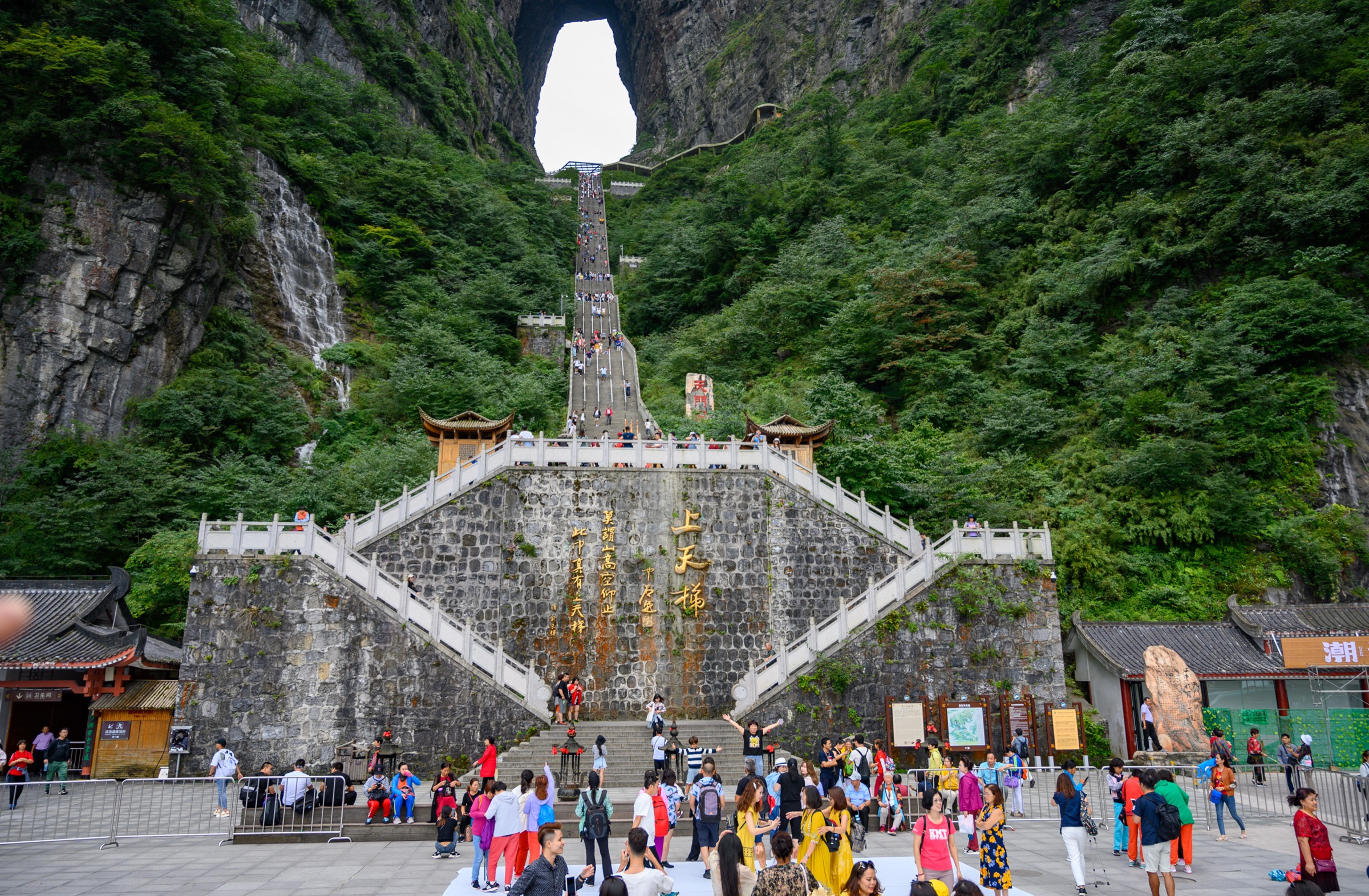
The 999-step stair is Tianmen’s signature short objective: a near-straight stone stairway climbing directly through the south face of the summit ridge to Tianmen Cave, the 131.5 m collapse-arch that gives the mountain its name. The walk begins at Tianmen Cave Square at the top of the 11 km, 99-hairpin Tongtian Avenue, where the park shuttle drops at around 1,150 m. From the square a paved approach path crosses the small water-channel at the foot of the cliff and arrives at the base of the staircase. The 999 risers are arranged in eight flights with short landing terraces between them — Chinese tradition reads the number 9 as the highest single-digit yang number, and 999 as a triple emphasis on heaven; the cave at the top is read as the gate between earth and sky. The lower flights are steepest; the gradient eases near the top. The cave platform stands roughly 1,300 m above sea level and opens directly into the natural arch, with the south horizon visible through the 57 m wide, 131.5 m high opening above. From the cave platform, the seven-stage upper escalator climbs into the mountain’s interior to the summit network; walkers may either continue up the escalator or descend the stair back to the square.
Why it is essential
This is the iconic Tianmen objective: short, steep, immediately recognisable, and the only walking section in China that climbs directly through the world’s tallest naturally formed mountain arch. The combination of the stair count, the cave geometry and the Tongtian Avenue approach below makes the 999-step Sky Ladder the single most photographed feature on the mountain and the canonical Tianmen image.
Equipment
- Grippy trail shoes; the stone risers are smooth and slick in rain
- Light layer; the cave platform is shaded and cooler than the square
- Sun protection on the lower flights
- Water; one small kiosk at the square, none on the stair
- Use the handrails on the descent — the stair is steeper than it looks
Hazards and notes
Wet stone, crowding, heat and vertigo combine to make this much harder than the 300 m distance suggests; the steps may close on safety grounds in lightning or icy conditions. The stair can run one-way uphill under peak crowd control; check the day’s signed direction before committing to a return on the same steps. The escalator behind the cave is the standard alternative descent and is included in the combined ticket. Tongtian Avenue is the road approach only — pedestrian access on the road itself is not permitted.
GPX / KML links
| Source | URL | Format | Notes |
|---|---|---|---|
| TravelChinaGuide — Tianmen Mountain | travelchinaguide.com | Route description | Reference only |
| Wikimedia Commons — 999 steps to Heaven’s Gate | commons.wikimedia.org | Media category | Image pool only |
| OpenStreetMap — Tianmen Cave | openstreetmap.org | OSM | ODbL 1.0 |
| No official park GPX | — | — | Not located |
Sources
5. Tianmen Temple to Yunmeng Xianding summit spur
Snapshot
Itinerary
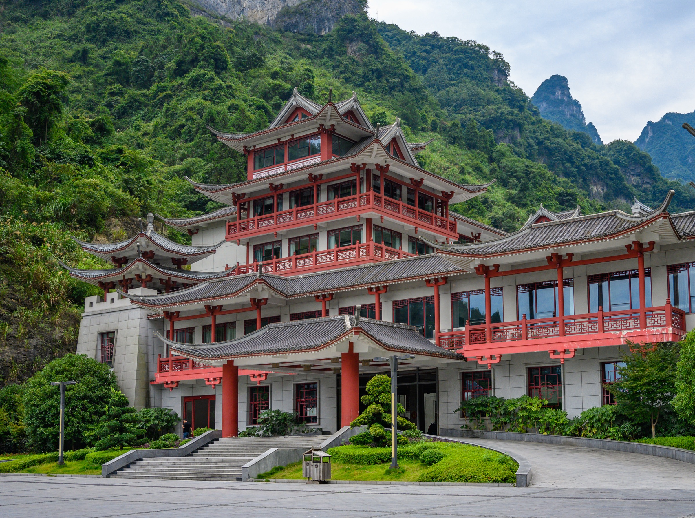
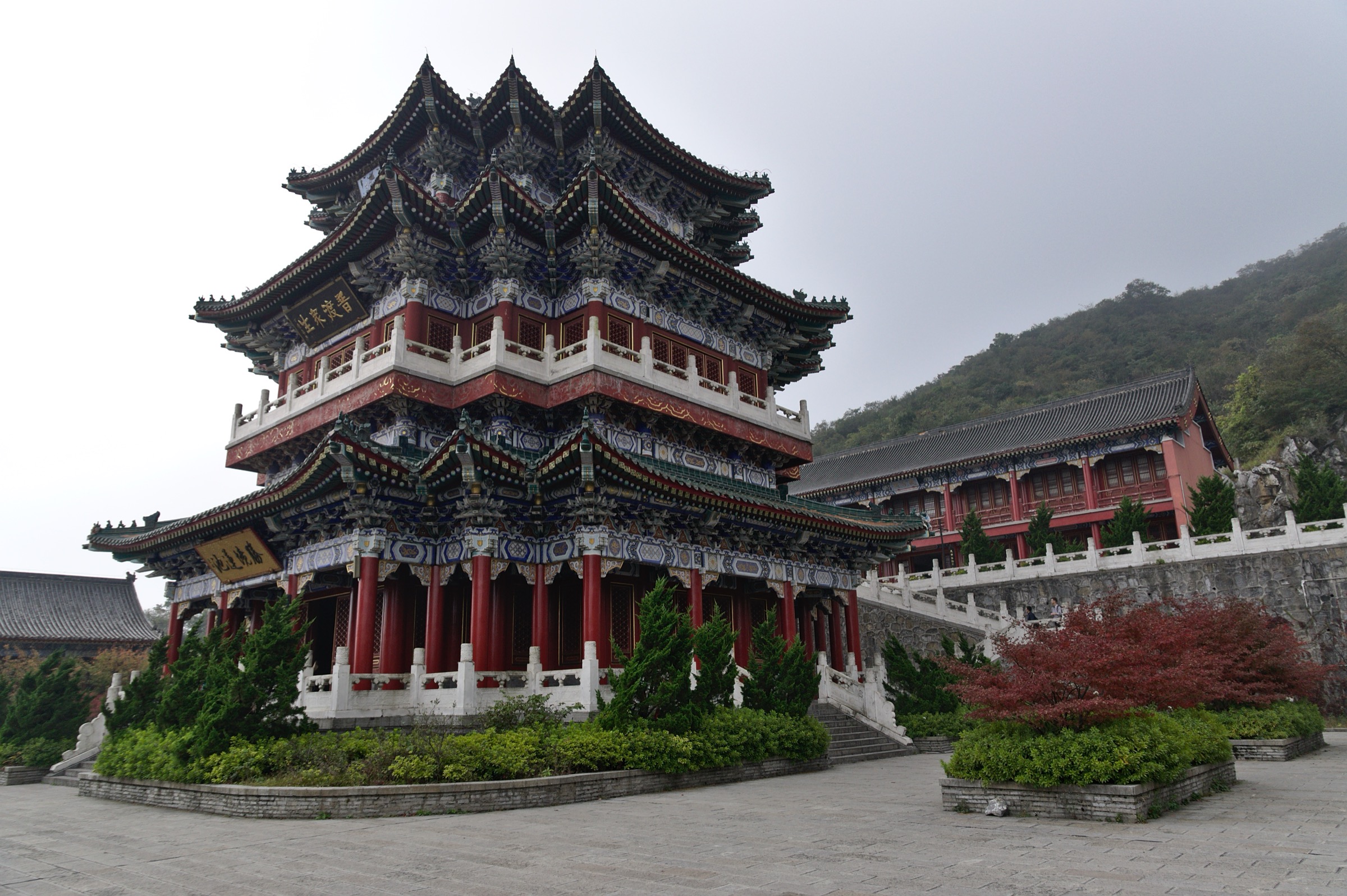
The summit spur leaves the East-Line / West-Line junction at the Tianmen Temple complex on the summit plateau at around 1,400 m. The temple itself is a 21st-century reconstruction of the Ming-era Yuntai Temple, sited on the foundations of a Tang-era hermitage and rebuilt during the 2005–2008 park development phase; the buildings are arranged in a small four-courtyard sequence on a south-facing terrace, with a working monastic community and a public hall accessible without further ticket. From the temple a paved path climbs north through a Pinus taiwanensis and Phyllostachys bamboo belt to the Yunmeng Xianding viewing platform at 1,518.6 m — the published mountain high point — with a 360-degree panorama across the Wuling foothills, the deep Pansi valley to the east, and the Tongtian Avenue switchbacks visible directly below. A Forest Sightseeing Cable Car (森林观光缆车) parallels the foot path between the temple and the summit and is included in the combined ticket; walkers may use the cable car one way and the path the other for a short loop. The return drops back to the temple and rejoins the East-Line / West-Line summit circuit. Distance, gain and time figures are estimates — the park authority does not publish authoritative trail statistics for this spur.
Why it is essential
This spur adds the cultural centre of Tianmen Mountain and the published high point at 1,518.6 m, rounding out the day beyond the cave, the cliff balconies and the glass walkways. None of the other four hikes reach the summit elevation, and Tianmen Temple is the only working religious site on the mountain — the cultural counterweight to the engineered cliff network elsewhere on the day.
Equipment
- Walking shoes; paths are paved or stepped throughout
- Light layer and rain shell — the summit is the most exposed point on the mountain
- Sun protection on the open ridge
- Water; refill at the temple
- Light hat / gloves in shoulder season — the summit can sit several degrees below the cableway upper station
Hazards and notes
The summit and its sightseeing cable car close in lightning, high wind and dense fog; the spur is the most weather-sensitive walk on the mountain. Yunmeng Xianding views can be entirely cloud-blocked even when the lower summit network is clear — a high pressure morning is the cleanest equivalent. The temple area is photographically restricted in the inner halls; observe local signage. Distance, gain and time figures above are estimates; the park authority does not publish authoritative statistics for this spur.
GPX / KML links
| Source | URL | Format | Notes |
|---|---|---|---|
| TravelChinaGuide — Tianmen Mountain | travelchinaguide.com | Route description | Feature and access facts only |
| Wikimedia Commons — Tianmen Mountain | commons.wikimedia.org | Media category | Image pool only |
| OpenStreetMap — Tianmen summit | openstreetmap.org | OSM | ODbL 1.0; partial coverage |
| No official park GPX | — | — | Not located |
Sources
- TravelChinaGuide — Tianmen Mountain
- China Highlights — Tianmen Mountain
- Wikipedia — Tianmen Mountain
Missing data / follow-up work
- Visitor-line routing (Line A / B / C) is decided by the park authority each morning and changes which end of the cliff network walkers start from; confirm the current letter at the lower cableway gate before committing to a sequence.
- West Line and East Line elevation gain / loss figures here are estimates synthesised from cliff-path contour profiles; the park authority does not publish authoritative trail statistics and these should be replaced with surveyed values when available.
- Tianmen Temple to Yunmeng Xianding spur lacks an authoritative published distance, gain and time; figures here are estimates and should be replaced with surveyed values when available.
- Commons categories for the Western and Eastern Cliffside Paths contain candidate images but no file-level licence and attribution were fully verified for those specific sections in this pass; replace with surveyed photographs when available.
- The Tianmen combined ticket, shuttle and cable-car pricing changes seasonally; re-check at the lower cableway gate or on the official park site within a month of travel.
- A clean walking-only GPX for the full circuit that separates the cableway, escalator and shuttle legs from the walking distance is still missing; the AllTrails trace remains the best third-party reference.
Further reading
| Source | URL |
|---|---|
| TravelChinaGuide — Tianmen Mountain | travelchinaguide.com |
| China Highlights — Tianmen Mountain | chinahighlights.com |
| AllTrails — Tianmen Mountain | alltrails.com |
| Wikipedia — Tianmen Mountain | en.wikipedia.org |
| Wikipedia — Tianmen Mountain Cableway | en.wikipedia.org |
| Wikimedia Commons — Category:Tianmen Mountain | commons.wikimedia.org |
| Wikimedia Commons — Western Cliffside Path | commons.wikimedia.org |
| Wikimedia Commons — Eastern Cliffside Path | commons.wikimedia.org |
| OpenStreetMap — Tianmen Mountain area | openstreetmap.org |